Ashdown, Arkansas | |
|---|---|
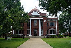 Little River County Courthouse | |
 Location of Ashdown in Little River County, Arkansas. | |
 Ashdown Location in Arkansas  Ashdown Location in the United States | |
| Coordinates: 33°40′26″N94°07′18″W / 33.67389°N 94.12167°W | |
| Country | United States |
| State | Arkansas |
| County | Little River |
| Incorporated | June 11, 1892 |
| Area | |
• Total | 7.17 sq mi (18.56 km2) |
| • Land | 7.14 sq mi (18.49 km2) |
| • Water | 0.031 sq mi (0.08 km2) |
| Elevation | 328 ft (100 m) |
| Population (2020) | |
• Total | 4,261 |
• Estimate (2024) | 4,088 |
| • Density | 597.0/sq mi (230.51/km2) |
| Time zone | UTC−06:00 (Central (CST)) |
| • Summer (DST) | UTC−05:00 (CDT) |
| ZIP Code | 71822 |
| Area code | 870 |
| FIPS code | 05-02380 |
| GNIS feature ID | 2403118 [2] |
| Website | ashdownarkansas |
Ashdown (formerly Turkey Flats and Keller) is a city in Little River County, Arkansas, United States. The community was incorporated in 1892 and has been the county seat since 1906. [3] Located within the Arkansas Timberlands between the Little River and the Red River, Ashdown's economy and development have historically been tied to the timber industry. Timber is still a major industry here.
Contents
- History
- Geography
- Climate
- Demographics
- 2020 census
- 2020 census 2
- Arts and culture
- Annual cultural events
- Tourism
- Politics
- Education
- Media
- Notable people
- See also
- References
- External links
Ashdown's population at the 2020 census was 4,261, [4] a slight from the 2010 census. The city's well-preserved history and proximity to outdoor recreation, such as Millwood State Park, draws tourists. [5]


