Mount Ida, Arkansas

Last updated

Mount Ida, Arkansas
Montgomery County Courthouse 003.jpg
Montgomery County Courthouse in downtown Mount Ida
Motto: 
"Quartz Crystal Capital of the World" [1]
Montgomery County Arkansas Incorporated and Unincorporated areas Mount Ida Highlighted 0547690.svg
Location in Montgomery County, Arkansas
Coordinates: 34°33′03″N93°37′51″W / 34.55083°N 93.63083°W / 34.55083; -93.63083 [2]
Country United States
State Arkansas
County Montgomery
Incorporated (city)May 30, 1890 [3]
Area
[4]
  Total1.60 sq mi (4.14 km2)
  Land1.57 sq mi (4.06 km2)
  Water0.03 sq mi (0.08 km2)
Elevation
[2]
643 ft (196 m)
Population
 (2020) [5]
  Total996
  Density634.80/sq mi (245.06/km2)
Time zone UTC-6 (Central (CST))
  Summer (DST) UTC-5 (CDT)
ZIP code
71957
Area code 870
FIPS code 05-47690
GNIS feature ID0077718

Mount Ida is a city in and county seat of Montgomery County, Arkansas, United States. Founded in 1842, the city saw a silver boom in the 1880s bring early prosperity and economic development to the area. Today, the economy is largely ranching, poultry farming, silviculture, and tourism around Lake Ouachita. It is known as the quartz crystal capital of the U.S. and is known worldwide for its quartz deposits. [1] The population was 996 as of the 2020 census. [5]

Contents

History

Mount Ida was incorporated on May 30, 1890. [3]

Episode 133, entitled "What's in my Pocket?", of the popular podcast Small Town Murder, hosted by James Pietragallo and Jimmie Whisman, featured Mount Ida on August 22, 2019.

Geography

Arkansas quartz crystals WLA hmns Quartz Arkansas.jpg
Arkansas quartz crystals

Mount Ida is located in central Montgomery County on the south bank of the South Fork of the Ouachita River. US Route 270 and Arkansas Highway 27 pass through the town. [6] US 270 leads east 36 miles (58 km) to Hot Springs and northwest 86 miles (138 km) to Heavener, Oklahoma, while AR 27 leads northeast 46 miles (74 km) to Danville and southwest 9 miles (14 km) to Norman. Mount Ida, the mountain, is about 5 miles (8 km) southwest of the town along Route 27. [6]

According to the United States Census Bureau, the city of Mount Ida has a total area of 1.60 square miles (4.14 km2), of which 0.03 square miles (0.08 km2), or 1.94%, are water. [4]

Climate

The climate in this area is characterized by hot, humid summers and generally mild to cool winters. According to the Köppen Climate Classification system, Mount Ida has a humid subtropical climate, abbreviated "Cfa" on climate maps. [7]

Climate data for Mount Ida, Arkansas (1991–2020 normals, extremes 1883–present)
MonthJanFebMarAprMayJunJulAugSepOctNovDecYear
Record high °F (°C)87
(31)
86
(30)
91
(33)
93
(34)
97
(36)
108
(42)
110
(43)
116
(47)
107
(42)
100
(38)
89
(32)
83
(28)
116
(47)
Mean daily maximum °F (°C)53.0
(11.7)
56.9
(13.8)
65.4
(18.6)
73.6
(23.1)
80.5
(26.9)
88.4
(31.3)
92.9
(33.8)
92.7
(33.7)
86.3
(30.2)
75.3
(24.1)
63.5
(17.5)
55.0
(12.8)
73.6
(23.1)
Daily mean °F (°C)41.8
(5.4)
45.5
(7.5)
53.3
(11.8)
61.5
(16.4)
69.4
(20.8)
77.2
(25.1)
81.0
(27.2)
80.4
(26.9)
73.4
(23.0)
62.2
(16.8)
51.5
(10.8)
43.6
(6.4)
61.7
(16.5)
Mean daily minimum °F (°C)30.7
(−0.7)
34.0
(1.1)
41.2
(5.1)
49.3
(9.6)
58.3
(14.6)
66.1
(18.9)
69.2
(20.7)
68.2
(20.1)
60.5
(15.8)
49.1
(9.5)
39.6
(4.2)
32.2
(0.1)
49.9
(9.9)
Record low °F (°C)−15
(−26)
−21
(−29)
4
(−16)
20
(−7)
30
(−1)
41
(5)
47
(8)
43
(6)
31
(−1)
20
(−7)
6
(−14)
−6
(−21)
−21
(−29)
Average precipitation inches (mm)3.81
(97)
4.04
(103)
5.01
(127)
6.17
(157)
5.44
(138)
4.77
(121)
4.20
(107)
3.66
(93)
4.14
(105)
4.44
(113)
5.25
(133)
4.82
(122)
55.75
(1,416)
Average precipitation days (≥ 0.01 in)8.69.910.99.912.09.810.28.37.69.39.19.4115.0
Source: NOAA [8] [9]

Demographics

Historical population
CensusPop.Note
1920 298
1930 51271.8%
1940 490−4.3%
1950 56615.5%
1960 564−0.4%
1970 81945.2%
1980 1,02324.9%
1990 775−24.2%
2000 98126.6%
2010 1,0769.7%
2020 996−7.4%
U.S. Decennial Census [10]

2020 census

Mount Ida racial composition [11]
RaceNumberPercentage
White (non-Hispanic)86987.25%
Black or African American (non-Hispanic)40.4%
Native American 161.61%
Asian 10.1%
Pacific Islander 30.3%
Other/Mixed 555.52%
Hispanic or Latino 484.82%

As of the 2020 United States census, there were 996 people, 428 households, and 273 families residing in the city.

2000 census

As of the census [12] of 2000, there were 981 people, 412 households, and 257 families residing in the city. The population density was 598.5 inhabitants per square mile (231.1/km2). There were 471 housing units at an average density of 287.4 per square mile (111.0/km2). The racial makeup of the city was 96.53% White, 0.10% Black or African American, 1.94% Native American, 0.31% Asian, 0.10% from other races, and 1.02% from two or more races. 0.51% of the population were Hispanic or Latino of any race.

There were 412 households, out of which 22.1% had children under the age of 18 living with them, 46.8% were married couples living together, 11.9% had a female householder with no husband present, and 37.6% were non-families. 35.4% of all households were made up of individuals, and 23.3% had someone living alone who was 65 years of age or older. The average household size was 2.15 and the average family size was 2.74.

In the city, the population was spread out, with 19.2% under the age of 18, 6.6% from 18 to 24, 18.3% from 25 to 44, 21.7% from 45 to 64, and 34.1% who were 65 years of age or older. The median age was 50 years. For every 100 females, there were 78.0 males. For every 100 females age 18 and over, there were 72.0 males.

The median income for a household in the city was $21,438, and the median income for a family was $30,714. Males had a median income of $25,875 versus $20,179 for females. The per capita income for the city was $13,532. About 18.9% of families and 23.4% of the population were below the poverty line, including 29.2% of those under age 18 and 16.0% of those age 65 or over.

Parks and recreation

Lake Ouachita north of Mount Ida, Arkansas Lake Ouachita north of Mount Ida, Arkansas.jpg
Lake Ouachita north of Mount Ida, Arkansas

The Ouachita National Forest is located in Montgomery County, and is close to Mount Ida. It is the South's oldest and largest national forest, [1] and offers scenic areas like Little Missouri Falls, and hiking and backpacking trails. [13] Lake Ouachita, one of the largest lakes in the region, is partially situated within Montgomery County.

Notable people

Related Research Articles

<span class="mw-page-title-main">Montgomery County, Arkansas</span> County in Arkansas, United States

Montgomery County is a county in the U.S. state of Arkansas. As of the 2020 census, the population was 8,484. The county seat is Mount Ida. Montgomery County is Arkansas's 45th county, formed on December 9, 1842, and named after Richard Montgomery, an American Revolutionary War general.

<span class="mw-page-title-main">Scott County, Arkansas</span> County in Arkansas, United States

Scott County is a county located in the U.S. state of Arkansas. As of the 2020 census, the population was 9,836. The county seat is Waldron. Scott County is Arkansas' 28th county, formed on November 5, 1833, and named for Andrew Scott, a justice of the Supreme Court of the Arkansas Territory. It is an alcohol-prohibited or dry county.

<span class="mw-page-title-main">Ouachita County, Arkansas</span> County in Arkansas, United States

Ouachita County is a county located in the south central part of the U.S. state of Arkansas. As of the 2020 census, the population was 22,650.

<span class="mw-page-title-main">Calera, Alabama</span> City in Alabama, United States

Calera is a city in Shelby and Chilton counties in the U.S. state of Alabama. It is the location of the Shelby County Airport.

<span class="mw-page-title-main">Beaver, Arkansas</span> Town in Arkansas, United States

Beaver is a town in Carroll County, Arkansas, United States. As of the 2020 census it had a population of 67. The community is located on the White River at the western limits of Table Rock Lake deep in the Ozark Mountains. Located north of Eureka Springs, the small town has been featured in movies for its picturesque scenery. The town is known for the Beaver Bridge, a two-panel suspension bridge over the White River listed on the National Register of Historic Places.

<span class="mw-page-title-main">Dermott, Arkansas</span> City in Arkansas, United States

Dermott is a city in Chicot County, Arkansas, United States. The population was 2,316 at the 2010 census. Dermott was incorporated in 1890.

<span class="mw-page-title-main">Arkadelphia, Arkansas</span> City in Arkansas, United States

Arkadelphia is a city in Clark County, Arkansas, United States. As of the 2020 census, the population was 10,380. The city is the county seat of Clark County. It is situated at the foothills of the Ouachita Mountains. Two universities, Henderson State University and Ouachita Baptist University, are located here. Arkadelphia was incorporated in 1857.

<span class="mw-page-title-main">Bono, Arkansas</span> Bono in Arkansas, United States

Bono is a city in Craighead County, Arkansas, United States. The population was 2,131 at the 2010 census, up from 1,512 in 2000. It is included in the Jonesboro, Arkansas Metropolitan Statistical Area. Bono's most prominent landmarks are the Bono Bridge and the Bono Cemetery.

<span class="mw-page-title-main">Mountain Pine, Arkansas</span> City in Arkansas, United States

Mountain Pine is a city in Garland County, Arkansas, United States. It is part of the Hot Springs Metropolitan Statistical Area. The population was 770 at the 2010 United States Census. It is located immediately southeast of Lake Ouachita below the Blakely Mountain Dam. The city consists of five defined neighborhoods, Pinewood (north), South Mountain Pine, a business district, Cozy Acres (southwest) and Mountain View/Timberland area.

<span class="mw-page-title-main">Donaldson, Arkansas</span> Town in Arkansas, United States

Donaldson is a town in Hot Spring County, Arkansas, United States. The population was 301 at the 2010 census.

<span class="mw-page-title-main">Batesville, Arkansas</span> City in Arkansas, United States

Batesville is the county seat and largest city of Independence County, Arkansas, United States, 80 miles (183 km) northeast of Little Rock, the state capital. According to the 2010 Census, the population of the city was 10,268. The city serves as a regional manufacturing and distribution hub for the Ozark Mountain region and Northeast Arkansas.

<span class="mw-page-title-main">Walnut Ridge, Arkansas</span> City in Arkansas, United States

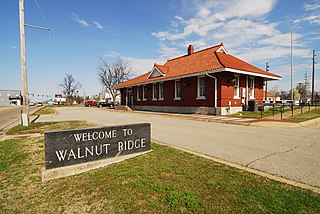
Walnut Ridge is a city in and the county seat of Lawrence County, Arkansas, United States. The population was 5,098 at the United States Census's 2019 estimate. Walnut Ridge lies immediately north of Hoxie. The two towns form a contiguous urban area with approximately 8,000 residents. Williams Baptist University is in College City, a formerly separate community that merged into Walnut Ridge in 2017.

<span class="mw-page-title-main">Manila, Arkansas</span> City in Arkansas, United States

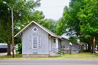
Manila is a city in Mississippi County, Arkansas, United States. The population was 3,682 at the 2020 census, up from 3,342 in 2010. It was the hometown of World War I sniper Herman Davis.

<span class="mw-page-title-main">Black Springs, Arkansas</span> Town in Arkansas, United States

Black Springs is a town in Montgomery County, Arkansas, United States. The population was 96 at the 2020 census.

<span class="mw-page-title-main">Norman, Arkansas</span> Town in Arkansas, United States

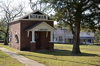
Norman is a town in Montgomery County, Arkansas, United States. It was known as Womble until 1925. The population was 303 at the 2020 census, down from 378 in 2010.

<span class="mw-page-title-main">Oden, Arkansas</span> Town in Arkansas, United States

Oden is a town in Montgomery County, Arkansas, United States. As of the 2020 census, its population was 180, down from 232 in 2010.

<span class="mw-page-title-main">Glenwood, Arkansas</span> City in Arkansas, United States

Glenwood is a city in Pike and Montgomery counties in Arkansas, United States. As of the 2020 census, its population was 2,068. The community is located along the Caddo River in the Ouachita Mountains.

<span class="mw-page-title-main">Mena, Arkansas</span> City in Arkansas, United States

Mena is a city in Polk County, Arkansas, United States. It is also the county seat of Polk County. The population was 5,558 as of the 2020 census. Mena is included in the Ark-La-Tex socio-economic region. Surrounded by the Ouachita National Forest, Mena is a gateway to some of the most visited tourist attractions in Arkansas.

<span class="mw-page-title-main">Benton, Arkansas</span> City in Arkansas, United States

Benton is a city in and the county seat of Saline County, Arkansas, United States and a suburb of Little Rock. It was established in 1837. At the 2020 census, the city had a population of 35,014, making it the 12th most populous city in Arkansas. It is part of the Little Rock–North Little Rock–Conway Metropolitan Statistical Area. The city of Benton, first settled in 1833 and named after Missouri Senator Thomas Hart Benton, was formally chartered in 1836 when Arkansas became a state.

<span class="mw-page-title-main">Loudon, Tennessee</span> City in Tennessee, United States

Loudon is a city in and the county seat of Loudon County, Tennessee, United States. Its population was 6,001 at the 2020 census. It is included in the Knoxville, Tennessee Metropolitan Statistical Area. The city is located in East Tennessee, southwest of Knoxville, on the Tennessee River. Fort Loudoun, the colonial era fort for which the city was named, is located several miles to the south in Monroe County.

References

  1. 1 2 3 "Mount Ida Chamber of Commerce". Mount Ida Chamber of Commerce. Retrieved September 12, 2012.
  2. 1 2 U.S. Geological Survey Geographic Names Information System: Mount Ida, Arkansas
  3. 1 2 "Mount Ida, Arkansas". City-Data.com. Retrieved September 12, 2012.
  4. 1 2 "2021 U.S. Gazetteer Files: Arkansas". United States Census Bureau. Retrieved June 23, 2022.
  5. 1 2 "P1. Race – Mount Ida city, Arkansas: 2020 DEC Redistricting Data (PL 94-171)". U.S. Census Bureau. Retrieved June 23, 2022.
  6. 1 2 Mount Ida, Arkansas, 7.5 Minute Topographic Quadrangle, USGS, 1986
  7. "Mount Ida, Arkansas Köppen Climate Classification (Weatherbase)". Weatherbase. Retrieved November 7, 2023.
  8. "NowData – NOAA Online Weather Data". National Oceanic and Atmospheric Administration. Retrieved June 20, 2021.
  9. "Station: Mount Ida ASOS, AR". U.S. Climate Normals 2020: U.S. Monthly Climate Normals (1991-2020). National Oceanic and Atmospheric Administration. Retrieved June 20, 2021.
  10. "Census of Population and Housing". Census.gov. Retrieved June 4, 2015.
  11. "Explore Census Data". data.census.gov. Retrieved December 31, 2021.
  12. "U.S. Census website". United States Census Bureau . Retrieved January 31, 2008.
  13. "Mount Ida". The Official Site of Arkansas Department of Parks & Tourism. Retrieved September 12, 2012.
  14. Mark Davis' Texas Bass Fishing Bio page
  15. Reichler, Joseph L., ed. (1979) [1969]. The Baseball Encyclopedia (4th ed.). New York: Macmillan Publishing. ISBN   0-02-578970-8.
  16. "Congressional Record, January 4, 1965" (PDF). govinfo.gov. U.S. Government Publishing Office. Retrieved December 24, 2021.