Star City, Arkansas

Last updated

Star City, Arkansas
Star City Clock Tower 001.jpg
Clock tower on the town square
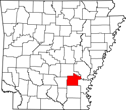
Lincoln County Arkansas Incorporated and Unincorporated areas Star City Highlighted 0566440.svg
Location of Star City in Lincoln County, Arkansas.
Coordinates: 33°56′27″N91°50′33″W / 33.94083°N 91.84250°W / 33.94083; -91.84250
Country United States
State Arkansas
County Lincoln
Area
[1]
  Total4.80 sq mi (12.43 km2)
  Land4.80 sq mi (12.43 km2)
  Water0.00 sq mi (0.00 km2)
Elevation
272 ft (83 m)
Population
 (2020)
  Total2,173
  Density452.99/sq mi (174.89/km2)
Time zone UTC-6 (Central (CST))
  Summer (DST) UTC-5 (CDT)
ZIP code
71667
Area code 870
FIPS code 05-66440
GNIS feature ID0078447

Star City is a city in, and the county seat of, Lincoln County, Arkansas, United States. [2] Incorporated in 1876, the city is located between the Arkansas Delta and Arkansas Timberlands. With an economy historically based on agriculture, today Star City has developed a diverse economy based on both industry and agriculture. [3] As of the 2010 census, the population was 2,274. [4] Star City is located within the Pine Bluff metropolitan area.

Contents

Geography

Star City is located at 33°56′27″N91°50′33″W / 33.94083°N 91.84250°W / 33.94083; -91.84250 (33.940947, -91.842575). [5]

According to the United States Census Bureau, the city has a total area of 4.2 square miles (11 km2), all land.

The city is located between Monticello and Pine Bluff. [6]

Demographics

Historical population
CensusPop.Note
1890 204
1900 25123.0%
1910 39657.8%
1920 61655.6%
1930 93251.3%
1940 1,09017.0%
1950 1,29618.9%
1960 1,57321.4%
1970 2,03229.2%
1980 2,0661.7%
1990 2,1383.5%
2000 2,47115.6%
2010 2,274−8.0%
2020 2,173−4.4%
U.S. Decennial Census [7]

2020 census

Star City racial composition [8]
RaceNumberPercentage
White (non-Hispanic)1,56171.84%
Black or African American (non-Hispanic)40218.5%
Native American 60.28%
Asian 80.37%
Pacific Islander 10.05%
Other/Mixed 1205.52%
Hispanic or Latino 753.45%

As of the 2020 United States census, there were 2,173 people, 686 households, and 450 families residing in the city.

2000 census

As of the census [9] of 2000, there were 2,471 people, 875 households, and 603 families residing in the city. The population density was 587.5 inhabitants per square mile (226.8/km2). There were 972 housing units at an average density of 231.1 per square mile (89.2/km2). The racial makeup of the city was 76.93% White, 21.08% Black or African American, 0.61% Native American, 0.04% from other races, and 0.77% from two or more races. 1.21% of the population were Hispanic or Latino of any race.

There were 875 households, out of which 37.4% had children under the age of 18 living with them, 46.5% were married couples living together, 18.6% had a female householder with no husband present, and 31.0% were non-families. 28.8% of all households were made up of individuals, and 15.8% had someone living alone who was 65 years of age or older. The average household size was 2.52 and the average family size was 3.10.

In the city, the population was spread out, with 27.0% under the age of 18, 7.9% from 18 to 24, 24.8% from 25 to 44, 17.5% from 45 to 64, and 22.9% who were 65 years of age or older. The median age was 38 years. For every 100 females, there were 75.4 males. For every 100 females age 18 and over, there were 69.8 males.

The median income for a household in the city was $32,197, and the median income for a family was $40,156. Males had a median income of $34,107 versus $19,630 for females. The per capita income for the city was $13,998. About 15.9% of families and 18.2% of the population were below the poverty line, including 27.0% of those under age 18 and 11.8% of those age 65 or over.

Arts and culture

Star City was the setting for the 1992 police thriller film One False Move , starring actors Bill Paxton and Billy Bob Thornton, and written by Thornton. However, only limited filming was done there with the bulk of the movie shot in Cotton Plant, Arkansas. [10]

Annual cultural events

Star City used to be the home of the annual STARDAZE festival. The festival used to draw people from all over southeastern Arkansas.

Education

Star City High School Star City High School.jpg
Star City High School

The Star City School District operates public schools: [6] Jimmy Brown Elementary School, Star City Middle School, and Star City High School.

The Southeast Arkansas Public Library operates the Star City Branch Library. [11]

Infrastructure

Transportation

Roads

Highway 11 near the US 425 intersection in Star City Highway 11 in Star City, AR.jpg
Highway 11 near the US 425 intersection in Star City

Star City is located at the intersection of US Highway 425 (US 425) and Highway 11 (AR 11). US 425 is a major north-south highway in southeast Arkansas and connects the city to Pine Bluff to the north and Monticello to the south. AR 11 provides access to Gould and US 65 to the east and US 63 to the west.

AR 530 currently terminates near Star City. This route is a two-lane freeway segment of a future extension of Interstate 530 (I-530) south to Monticello. In Monticello, the planned extension will connect to future Interstate 69, a proposed road connecting Port Huron, Michigan, and Rosenberg, Texas.

Related Research Articles

<span class="mw-page-title-main">Lincoln County, Arkansas</span> County in Arkansas, United States

Lincoln County is located between the Arkansas Timberlands and Arkansas Delta in the U.S. state of Arkansas. It is also within the Pine Bluff metro area, and on the outer edge of the Central Arkansas region. The county is named for President Abraham Lincoln. Created as Arkansas's 65th county on March 28, 1871, Lincoln County has three incorporated cities, including Star City, the county seat and most populous city. The county contains 46 unincorporated communities and ghost towns, Cane Creek State Park at the confluence of Cane Creek and Bayou Bartholomew, and nine listings on the National Register of Historic Places to preserve the history and culture of the county.

<span class="mw-page-title-main">Jefferson County, Arkansas</span> County in Arkansas, United States

Jefferson County, Arkansas is a county located in the U.S. state of Arkansas in the area known as the Arkansas Delta that extends west of the Mississippi River. Jefferson County consists of five cities, two towns, and 20 townships. The county is bisected by the Arkansas River, which was critical to its development and long the chief transportation byway. In 2020, Jefferson County's population was estimated at 67,260. Its county seat and largest city is Pine Bluff. Jefferson County is included in the Pine Bluff metropolitan statistical area. The county seat and the most populous city is Pine Bluff.

<span class="mw-page-title-main">Fulton County, Arkansas</span> County in Arkansas, United States

Fulton County is a county located in the U.S. state of Arkansas. As of the 2020 census, the population was 12,075. The county seat is Salem. Fulton County was formed on December 21, 1842, and named for William Fulton, the last governor of the Arkansas Territory. It is an alcohol prohibition or dry county.

<span class="mw-page-title-main">Drew County, Arkansas</span> County in Arkansas, United States

Drew County is a county located in the southeast region of the U.S. state of Arkansas. As of the 2020 census, the population was 17,350. The county seat and largest city is Monticello. Drew County was formed on November 26, 1846, and named for Thomas Drew, the third governor of Arkansas.

<span class="mw-page-title-main">Cleveland County, Arkansas</span> County in Arkansas, United States

Cleveland County is a county located in the U.S. state of Arkansas. Its population was 7,550 at the 2020 U.S. census. The county seat and largest city is Rison.

<span class="mw-page-title-main">Humphrey, Arkansas</span> City in Arkansas, United States

Humphrey is a city in Arkansas and Jefferson counties in the U.S. state of Arkansas. Its population was 557 at the 2010 census. It is included in the Pine Bluff Metropolitan Statistical Area.

<span class="mw-page-title-main">Norfork, Arkansas</span> City in Arkansas, United States

Norfork is a city in Baxter County, Arkansas, United States. The population was 550 at the 2010 census.

<span class="mw-page-title-main">St. Francis, Arkansas</span> City in Arkansas, United States

St. Francis is a city in northeastern Clay County, Arkansas, United States, along the St. Francis River. The population was 250 at the 2010 census.

<span class="mw-page-title-main">Dumas, Arkansas</span> City in Arkansas, United States

Dumas is a city in Desha County, Arkansas, United States. The population was 4,706 at the 2010 census.

<span class="mw-page-title-main">Tillar, Arkansas</span> Town in Arkansas, United States

Tillar is a town in Desha and Drew counties in the U.S. state of Arkansas. The population was 225 at the 2010 census. The area west of it was known as Tillar Station. Frank Tillar Memorial Methodist Episcopal Church, South is listed on the National Register of Historic Places.

<span class="mw-page-title-main">Monticello, Arkansas</span> City in Arkansas, United States

Monticello is a college town in, and the county seat of, Drew County, Arkansas. As of the 2010 census it had a population of 9,467. Founded in 1849 in the Arkansas Timberlands near the Arkansas Delta region, the city has long been a commercial, cultural and educational hub for southeast Arkansas. With a historically agriculture- and silviculture-based economy, it has diversified to include growth from the medical sector and the University of Arkansas at Monticello.

<span class="mw-page-title-main">Wilmar, Arkansas</span> City in Arkansas, United States

Wilmar is a city in Drew County, Arkansas, United States. The population was 511 at the 2010 census, down from 571 in 2000.

<span class="mw-page-title-main">Sherrill, Arkansas</span> Town in Arkansas, United States

Sherrill is a town in Plum Bayou Township, Jefferson County, Arkansas, United States. Its population was 84 at the 2010 U.S. census. It is included in the Pine Bluff, Arkansas Metropolitan Statistical Area.

<span class="mw-page-title-main">Wabbaseka, Arkansas</span> Town in Arkansas, United States

Wabbaseka is a town in Dunnington Township, Jefferson County, Arkansas, United States. Its population was 255 at the 2010 U.S. census. It is included in the Pine Bluff, Arkansas Metropolitan Statistical Area.

<span class="mw-page-title-main">White Hall, Arkansas</span> City in Arkansas, United States

White Hall is a city in Washington Township, located in Jefferson County, Arkansas, United States. With a population of 5,526 in the 2010 census, it is included in the Pine Bluff Metropolitan Statistical Area and the greater Little Rock-North Little Rock-Pine Bluff Combined Statistical Area. White Hall is home to the Pine Bluff Arsenal.

<span class="mw-page-title-main">Smithville, Arkansas</span> Town in Arkansas, United States

Smithville is a town in Lawrence County, Arkansas, United States. The population was 78 at the 2010 census.

<span class="mw-page-title-main">Grady, Arkansas</span> City in Arkansas, United States

Grady is a city in Lincoln County, Arkansas, United States. The population was 305 at the 2020 census, down from 449 at the 2010 census. It is included in the Pine Bluff, Arkansas Metropolitan Statistical Area.

<span class="mw-page-title-main">Morrison Bluff, Arkansas</span> Town in Arkansas, United States

Morrison Bluff is a town in Logan County, Arkansas, United States. The population was 64 at the 2010 census and an estimated 81 in 2017.

<span class="mw-page-title-main">DeValls Bluff, Arkansas</span> City in Arkansas, United States

DeValls Bluff is a city in and the county seat of the southern district of Prairie County, Arkansas, United States. The population was 619 at the 2010 census.

<span class="mw-page-title-main">Monticello, Maine</span> Town in the state of Maine, United States

Monticello is a town in Aroostook County, Maine, United States on the northern branch of the Meduxnekeag River. The population was 737 at the 2020 census. Originally known as Wellington Township, it was settled in 1830 by General Joel Wellington, who owned it, and incorporated in 1846. Some of the earlier migrant workers of Monticello were called the “Amerisee”—a currently disbanded tribe whose members consisted of tribal people from all five Wabanaki Maine tribes, who traveled together as migrant seasonal workers. Many of them had settled in the Monticello and other Aroostook County areas. The word “Amerisee” comes from the Mi’kmaq word “Amase’jijg” which means “some distance” or “quite far” in reference to the distance they traveled for work, which often included all areas of Canada and Aroostook County Maine. The Matthew(s) family shows up in the 1900 Census for Monticello Maine. They had intended to form a sixth tribe—one that accepted members from all five tribes who were originally one tribe, but due to colonization, it had been split up into the five groups known today. The Amerisee wished to reunite the five tribes. The attempt ultimately failed and the Amerisee tribal members, were reabsorbed into their tribes of origin. John Matthew, who is listed on the 1900 Census in Monticello Maine along with his family, writes that he is “Amerisee” however under “Tribe of Father of this Indian” and “Tribe of Mother of this Indian” he says they were both “mi’kmaw” which is the Mi’kmaq word for “Mi’kmaq”. His children were listed as Frank, Lizzie and Annie (Anastasia) Matthew. His parents were Frank and Bertha Matthew(s). He was also a basket maker. According to his death record, he was born in “Restigouche Ind.” territory, which is a testament to how far they would travel to reach farmland in places such as Monticello. John Matthew and other families like his, make up an interesting Native American element to Monticello’s migrant seasonal and farm work history. International shortwave broadcast station WBCQ is located here.

References

  1. "2020 U.S. Gazetteer Files". United States Census Bureau. Retrieved October 29, 2021.
  2. "Find a County". National Association of Counties. Retrieved June 7, 2011.
  3. DeArmond-Huskey, Rebecca. "Star City (Lincoln County)". The Encyclopedia of Arkansas History & Culture. The Butler Center for Arkansas Studies at Central Arkansas Library System . Retrieved July 5, 2014.
  4. "State & County QuickFacts". United States Census Bureau. Archived from the original on August 6, 2011. Retrieved May 19, 2014.
  5. "US Gazetteer files: 2010, 2000, and 1990". United States Census Bureau. February 12, 2011. Retrieved April 23, 2011.
  6. 1 2 "District Homepage Archived 2011-03-16 at the Wayback Machine ." Star City School District. Retrieved on March 6, 2011. "206 Cleveland Street, Arkansas"[ sic ]
  7. "Census of Population and Housing". Census.gov. Retrieved June 4, 2015.
  8. "Explore Census Data". data.census.gov. Retrieved December 30, 2021.
  9. "U.S. Census website". United States Census Bureau . Retrieved January 31, 2008.
  10. "BestFreeCams.club - Only the Best Free Live Cams".
  11. "Home". Southeast Arkansas Public Library. Retrieved May 18, 2023. - Check the hours and locations tab: "200 E. Wiley Star City, AR 71667"