Arkansas City, Arkansas

Last updated

Arkansas City, Arkansas
Town of Arkansas City
Arkansas City Commercial Historic District 001.jpg
Desha County Arkansas Incorporated and Unincorporated areas Arkansas City Highlighted 0501990.svg
Location in Desha County and Arkansas
Usa edcp relief location map.png
Red pog.svg
Arkansas City
Location in the United States
Coordinates: 33°36′32″N91°12′13″W / 33.60889°N 91.20361°W / 33.60889; -91.20361
Country Flag of the United States.svg  United States
State Flag of Arkansas.svg  Arkansas
County Desha
Township Franklin
Incorporated September 12, 1873
(150 years ago)
 (1873-09-12)
Government
  Type Mayor–Council
   Mayor Carolyn Blissett (I)
   Council Town Council
Area
[1]
  Total0.49 sq mi (1.28 km2)
  Land0.49 sq mi (1.28 km2)
  Water0.00 sq mi (0.00 km2)
Elevation
135 ft (41 m)
Population
 (2020)
  Total376
  Density764.23/sq mi (294.89/km2)
Time zone UTC-6 (Central (CST))
  Summer (DST) UTC-5 (CDT)
ZIP code
71630
Area code 870
FIPS code 05-01990
GNIS feature ID0076190

Arkansas City is a town in Desha County, Arkansas, United States. The population was 376 at the 2010 census. [2] The town is the county seat of Desha County. [3] Arkansas City Commercial District, located at Desoto Avenue and Sprague Street, is listed on the National Register of Historic Places.

Contents

History

Arkansas City, since 1879 the county seat of Desha County, was incorporated by the Chicot County Court on September 12, 1873, being then, and for some years later, in Chicot County. From 1879, it grew into a thriving riverport for the next forty years. It had a natural harbor for steamboats and two railways, as well as fourteen saloons and three sawmills. An opera house was moved to Arkansas City in 1891. The building was also used as an unofficial "town hall"; at other times it became a ballroom, and citizens danced to music of groups from Memphis, Tennessee.

Until the flood of 1927, Arkansas City was an important commercial and cultural center and one of the most important ports on the Mississippi River. The flood devastated the settlement. More than 2,000 people had to be rescued. As a result, the riverport closed and made the railroads unnecessary. [4]

Geography

According to the United States Census Bureau, the town has a total area of 0.5 square miles (1.3 km2), all land. It sits entirely in the Delta Lowlands sub-region of the Arkansas Delta.

Demographics

2020 census

Arkansas City racial composition [5]
RaceNum.Perc.
White (non-Hispanic)19351.33%
Black or African American (non-Hispanic)16243.09%
Native American 10.27%
Other/Mixed 133.46%
Hispanic or Latino 71.86%

As of the 2020 United States census, there were 376 people, 174 households, and 140 families residing in the city.

2000 census

As of the census [6] of 2000, there were 589 people, 231 households, and 161 families residing in the town. The population density was 1,232.2 inhabitants per square mile (475.8/km2). There were 279 housing units at an average density of 583.7 per square mile (225.4/km2). The racial makeup of the town was 55.01% White, 43.80% Black or African American, and 1.19% from two or more races. 3.23% of the population were Hispanic or Latino of any race.

There were 231 households, out of which 32.9% had children under the age of 18 living with them, 45.0% were married couples living together, 17.7% had a female householder with no husband present, and 30.3% were non-families. 27.3% of all households were made up of individuals, and 11.7% had someone living alone who was 65 years of age or older. The average household size was 2.55 and the average family size was 3.05.

In the town, the population was spread out, with 28.4% under the age of 18, 7.8% from 18 to 24, 26.0% from 25 to 44, 25.0% from 45 to 64, and 12.9% who were 65 years of age or older. The median age was 36 years. For every 100 females, there were 82.4 males. For every 100 females age 18 and over, there were 79.6 males.

The median income for a household in the town was $22,014, and the median income for a family was $27,500. Males had a median income of $36,250 versus $17,188 for females. The per capita income for the town was $14,523. About 25.3% of families and 31.8% of the population were below the poverty line, including 41.6% of those under age 18 and 37.6% of those age 65 or over.

1880-2020 census

Historical population
CensusPop.Note
1880 503
1900 1,091
1910 1,48536.1%
1920 1,482−0.2%
1930 1,432−3.4%
1940 1,4461.0%
1950 1,018−29.6%
1960 783−23.1%
1970 615−21.5%
1980 6688.6%
1990 523−21.7%
2000 58912.6%
2010 366−37.9%
2020 3762.7%
U.S. Decennial Census [7]

Education

Arkansas City High School (pre-1983 building) Arkansas City High School 003.jpg
Arkansas City High School (pre-1983 building)

Arkansas City is served by the McGehee School District. [8]

Previously the Arkansas City School District served Arkansas City. The district had two schools, Arkansas City Elementary School and Arkansas City High School. [9] In 2004 the Arkansas Legislature approved a law that forced school districts with fewer than 350 students apiece to consolidate with other districts. [10] [11] On July 1, 2004, the Arkansas City district merged into the McGehee district. [12] After the acquisition, the McGehee district continued to operate the Arkansas City campus as a K-6 school. [13] By October 2005 the district no longer operated the Arkansas City facility. [14]

Notable people

Related Research Articles

<span class="mw-page-title-main">Washington County, Mississippi</span> County in Mississippi, United States

Washington County is a county located in the U.S. state of Mississippi. As of the 2020 census, the population was 44,922. Its county seat is Greenville. The county is named in honor of the first president of the United States, George Washington. It is located to the Arkansas border.

<span class="mw-page-title-main">Bolivar County, Mississippi</span> County in Mississippi, United States

Bolivar County is a county located on the western border of the U.S. state of Mississippi. As of the 2020 census, the population was 30,985. Its county seats are Rosedale and Cleveland. The county is named in honor of Simón Bolívar, early 19th-century leader of the liberation of several South American territories from Spain.

<span class="mw-page-title-main">Phillips County, Arkansas</span> County in Arkansas, United States

Phillips County is a county located in the eastern part of the U.S. state of Arkansas, in what is known as the Arkansas Delta along the Mississippi River. As of the 2020 census, the population was 16,568. The county seat is Helena–West Helena.

<span class="mw-page-title-main">Drew County, Arkansas</span> County in Arkansas, United States

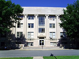
Drew County is a county located in the southeast region of the U.S. state of Arkansas. As of the 2020 census, the population was 17,350. The county seat and largest city is Monticello. Drew County was formed on November 26, 1846, and named for Thomas Drew, the third governor of Arkansas.

<span class="mw-page-title-main">Desha County, Arkansas</span> County in Arkansas, United States

Desha County is a county located in the southeast part of the U.S. state of Arkansas, with its eastern border the Mississippi River. At the 2020 census, the population was 11,395. The county seat is Arkansas City.

<span class="mw-page-title-main">Chicot County, Arkansas</span> County in Arkansas, United States

Chicot County is a county located in the southeastern corner of the U.S. state of Arkansas. As of the 2020 census, the population was 10,208. The county seat is Lake Village. Chicot County is Arkansas's 10th county, formed on October 25, 1823, and named after Point Chicot on the Mississippi River. It is part of the Arkansas Delta, lowlands along the river that have been historically important as an area for large-scale cotton cultivation.

<span class="mw-page-title-main">Dermott, Arkansas</span> City in Arkansas, United States

Dermott is a city in Chicot County, Arkansas, United States. The population was 2,316 at the 2010 census. Dermott was incorporated in 1890.

<span class="mw-page-title-main">Eudora, Arkansas</span> City in Arkansas, United States

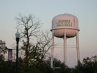
Eudora is a city in Chicot County, Arkansas, United States. The population was 2,269 at the 2010 census, down from 2,819 in 2000.

<span class="mw-page-title-main">Lake Village, Arkansas</span> City in Arkansas, United States

Lake Village is a city in and the county seat of Chicot County, Arkansas, United States. The population was 2,575 at the 2010 census. It is located in the Arkansas Delta. Lake Village is named for its location on Lake Chicot, an oxbow lake formed by the Mississippi River.

<span class="mw-page-title-main">McNeil, Arkansas</span> Town in Arkansas, United States

McNeil is a town in Columbia County, Arkansas, United States. The population was 516 at the 2010 census, down from 662 in 2000. The community was named after William B. McNeil, founder of the College Hill Academy.

<span class="mw-page-title-main">Dumas, Arkansas</span> City in Arkansas, United States

Dumas is a city in Desha County, Arkansas, United States. The population was 4,706 at the 2010 census.

<span class="mw-page-title-main">McGehee, Arkansas</span> City in Arkansas, United States

McGeheemə-GHEE is a city in Desha County, Arkansas, United States. The population was 4,219 at the 2010 census.

<span class="mw-page-title-main">Tillar, Arkansas</span> Town in Arkansas, United States

Tillar is a town in Desha and Drew counties in the U.S. state of Arkansas. The population was 225 at the 2010 census. The area west of it was known as Tillar Station. Frank Tillar Memorial Methodist Episcopal Church, South is listed on the National Register of Historic Places.

<span class="mw-page-title-main">Watson, Arkansas</span> City in Arkansas, United States

Watson is a city in Desha County, Arkansas, United States. The population was 211 at the 2010 census.

<span class="mw-page-title-main">Lewisville, Arkansas</span> City in Arkansas, United States

Lewisville is a city in Lafayette County, Arkansas, United States. The population was 1,280 at the 2010 census. It is the county seat of Lafayette County.

<span class="mw-page-title-main">Tyronza, Arkansas</span> City in Arkansas, United States

Tyronza is a city in Poinsett County, Arkansas, United States. The population was 716 at the 2020 census. It is included in the Jonesboro, Arkansas Metropolitan Statistical Area and is in the Arkansas Delta.

<span class="mw-page-title-main">Colt, Arkansas</span> Town in Arkansas, United States

Colt is a town and an unincorporated area in St. Francis County, Arkansas, United States. The population was 378 at the 2010 census, an increase from 368 in 2000.

<span class="mw-page-title-main">Rohwer, Arkansas</span> Unincorporated community in Arkansas, United States

Rohwer, Arkansas is an unincorporated community in Desha County, Arkansas, United States. The community is located on Arkansas Highway 1.

McGehee School District is a public school district headquartered in McGehee, Arkansas. The school district encompasses 499.14 square miles (1,292.8 km2) of land, in Drew and Desha counties.

The Delta Special School District was a school district of Rohwer, unincorporated Desha County, Arkansas, USA. Its territory is now in the McGehee School District. It also included Watson.

References

  1. "2020 U.S. Gazetteer Files". United States Census Bureau. Retrieved October 29, 2021.
  2. "Race, Hispanic or Latino, Age, and Housing Occupancy: 2010 Census Redistricting Data (Public Law 94-171) Summary File (QT-PL), Arkansas City city, Arkansas". United States Census Bureau . Retrieved August 15, 2011.
  3. "Find a County". National Association of Counties. Archived from the original on May 31, 2011. Retrieved June 7, 2011.
  4. CALS Encyclopedia of Arkansas | Arkansas City (Desha County)
  5. "Explore Census Data". data.census.gov. Retrieved December 12, 2021.
  6. "U.S. Census website". United States Census Bureau . Retrieved January 31, 2008.
  7. "Census of Population and Housing". Census.gov. Retrieved June 4, 2015.
  8. "2020 CENSUS - SCHOOL DISTRICT REFERENCE MAP: Desha County, AR" (PDF). U.S. Census Bureau . Retrieved March 11, 2023. - Text list - 2010 map
  9. "2002-2003 Arkansas Education Directory." Arkansas Department of Education. 54. Retrieved on March 6, 2011.
  10. "Dumas inherits Gould district’s deficit Archived July 7, 2011, at the Wayback Machine ." Arkansas News. May 11, 2005. Retrieved on March 7, 2011.
  11. "The MHS Alumni Café Archived September 15, 2011, at the Wayback Machine ." McGehee School District. Retrieved on July 27, 2011. "FYI... The Delta Special (Desha Central) and Arkansas City School Districts Consolidated with the McGehee School District as a result of a state mandate in 2004-2005."
  12. "Consolidation/Annexations of LEA's (1983-2010) Archived 2010-09-24 at the Wayback Machine ." Arkansas Department of Education. Retrieved on March 6, 2011.
  13. "Campuses." McGehee School District. August 28, 2004. Retrieved on July 28, 2011.
  14. "Campuses." McGehee School District. October 18, 2005. Retrieved on July 28, 2011.