Woodruff County is located in the Arkansas Delta in the U.S. state of Arkansas. The county is named for William E. Woodruff, founder of the state's first newspaper, the Arkansas Gazette. Created as Arkansas's 54th county in 1862, Woodruff County is home to one incorporated town and four incorporated cities, including Augusta, the county seat. The county is also the site of numerous unincorporated communities and ghost towns. Occupying only 587 square miles (152,000 ha), Woodruff County is the 13th smallest county in Arkansas. As of the 2020 Census, the county's population was 6,269. Based on population, the county is the second-smallest county of the 75 in Arkansas. Located in the Arkansas Delta, the county is largely flat with fertile soils. Historically covered in forest, bayous and swamps, the area was cleared for agriculture by early settlers. It is drained by the Cache River and the White River. Along the Cache River, the Cache River National Wildlife Refuge (NWR) runs north–south across the county, preserving bottomland forest, sloughs and wildlife habitat.
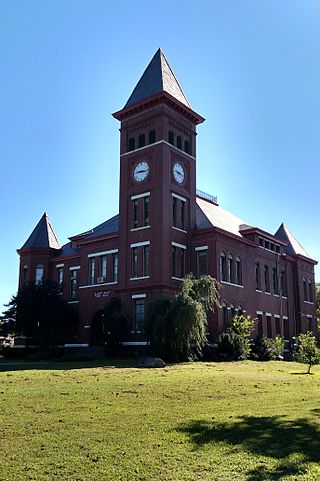
Stone County is located in the Ozark Mountains in the U.S. state of Arkansas. The county is named for rugged, rocky area terrain of the Ozarks. Created as Arkansas's 74th county on April 21, 1873, Stone County has two incorporated cities: Mountain View, the county seat and most populous city, and Fifty-Six. The county is also the site of numerous unincorporated communities and ghost towns.

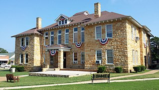
Randolph County is located between the Ozark Mountains and Arkansas Delta in the U.S. state of Arkansas. The county is named for John Randolph, a U.S. senator from Virginia influential in obtaining congressional approval of the Louisiana Purchase, which includes today's Randolph County. Created as Arkansas's 32nd county on October 29, 1835, Randolph County has two incorporated cities, including Pocahontas, the county seat and most populous city. The county is also the site of numerous unincorporated communities and ghost towns.
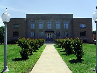
Lincoln County is located between the Arkansas Timberlands and Arkansas Delta in the U.S. state of Arkansas. It is also within the Pine Bluff metro area, and on the outer edge of the Central Arkansas region. The county is named for President Abraham Lincoln. Created as Arkansas's 65th county on March 28, 1871, Lincoln County has three incorporated cities, including Star City, the county seat and most populous city. The county contains 46 unincorporated communities and ghost towns, Cane Creek State Park at the confluence of Cane Creek and Bayou Bartholomew, and nine listings on the National Register of Historic Places to preserve the history and culture of the county.

Desha County is a county located in the southeast part of the U.S. state of Arkansas, with its eastern border the Mississippi River. At the 2020 census, the population was 11,395. The county seat is Arkansas City.

Ashley County is a rural South Arkansas county with a culture, economy, and history based on timber and agriculture. Created as Arkansas's 52nd county on November 30, 1848, Ashley County has seven incorporated municipalities, including Hamburg, the county seat and Crossett, the most populous city. The county is also the site of numerous unincorporated communities and ghost towns. The county is named for Chester Ashley, a prominent lawyer in the Arkansas Territory and U.S. senator from the state from 1844 to 1848.

Greenbrier is a city in Faulkner County, Arkansas, United States. It is part of the Central Arkansas region. The population was 5,707 at the 2020 census, up from 4,706 at the 2010 census.

U.S. Route 412 is an east–west United States highway, first commissioned in 1982. U.S. 412 overlaps expressway-grade Cimarron Turnpike from Tulsa west to Interstate 35 and the Cherokee Turnpike from 5 miles (8.0 km) east of Chouteau, Oklahoma, to 8 miles (13 km) west of the Arkansas state line. It runs the entire length of the Oklahoma Panhandle and traverses the Missouri Bootheel. Despite its numbering it is not associated with U.S. Route 12.

U.S. Route 71 or U.S. Highway 71 is a major north–south United States highway that extends for over 1500 miles (2500 km) in the central United States. This original 1926 route has remained largely unchanged by encroaching Interstate highways. Currently, the highway's northern terminus is in International Falls, Minnesota at the Canada–US border, at the southern end of the Fort Frances-International Falls International Bridge to Fort Frances, Ontario. U.S. Route 53 also ends here. On the other side of the bridge, Trans-Canada Highway is an east–west route while Ontario Highway 71 is a north–south route. US 71's southern terminus is between Port Barre and Krotz Springs, Louisiana at an intersection with U.S. Route 190. For the entirety south of Kansas City, Missouri, US 71 runs parallel and concurrent with the existing and future Interstate 49. North of Kansas City, US 71 runs halfway between Interstate 29 and Interstate 35, which they split in the city at an interchange with Interstate 70.

State Route 4 (SR 4) is a 62.27-mile-long (100.21 km) state highway, serving the southwestern region of the U.S. state of Washington. The highway, also known as Ocean Beach Highway, travels east along the Columbia River from U.S. Route 101 (US 101) at Johnston's Landing through Pacific, Wahkiakum and Cowlitz counties to an interchange with Interstate 5 (I-5) in Kelso. SR 4 is designated as part of the Lewis and Clark Trail Scenic Byway, a state scenic byway, as well as part of the National Highway System.

Highway 16 is an east–west state highway in Arkansas. The route begins in Siloam Springs at US Highway 412 (US 412) and Highway 59 and runs east through Fayetteville and the Ozark National Forest to US Highway 67 Business (US 67B) in Searcy. Highway 16 was created during the 1926 Arkansas state highway numbering, and today serves as a narrow, winding, 2-lane road except for overlaps of 10 miles (16 km) through Fayetteville. Much of the highway winds through the Ozarks, including the Ozark National Forest, where a portion of the highway is designated as an Arkansas Scenic Byway. The route has two spur routes in Northwest Arkansas; in Fayetteville and Siloam Springs.
Carrolls is an unincorporated community in Cowlitz County, Washington, south of the city of Kelso. Carrolls is located south on Old Pacific Highway from exit 36 of Interstate 5. The Carrolls community is part of the Kelso School District, a K-12 school district of nearly 5,000 students.
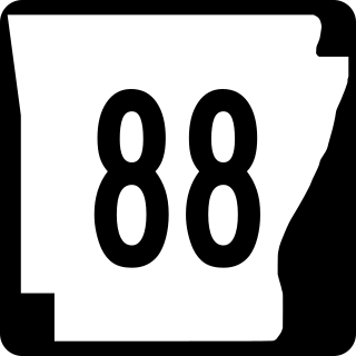
Highway 88 is a designation for five state highways in Arkansas. All routes are maintained by the Arkansas Department of Transportation (ArDOT).

The Arkansas Scenic Byways Program is a list of highways, mainly state highways, that have been designated by the Arkansas Department of Transportation (ArDOT) as scenic highways. The Arkansas General Assembly designates routes for scenic byway status upon successful nomination. For a highway to be declared scenic, a group interested in preserving the scenic, cultural, recreational, and historic qualities of the route must be created. Mayors of all communities along the route and county judges from each affected county must be included in the organization. Scenic highways are marked with a circular shield in addition to regular route markers.

State Route 432 (SR 432) is a 10.32-mile-long (16.61 km) state highway in the U.S. state of Washington, serving the cities of Longview and Kelso in Cowlitz County. The highway travels east along the Columbia River from an intersection with SR 4 in West Longview through the Port of Longview and the termini of SR 433 and SR 411 in Longview. SR 432 crosses the Cowlitz River on a divided highway and ends at an interchange with Interstate 5 (I-5) in Kelso. SR 432 was established during the 1964 highway renumbering as SR 832, replacing a branch of Primary State Highway 12 (PSH 12) that had been routed through Longview and Kelso since 1937. SR 432 was established in 1968 and originally routed on Nichols Boulevard within Longview and was re-aligned onto its current route in 1991 after the opening of Industrial Way.

State Route 411 (SR 411) is a 13.48-mile (21.69 km) state highway located in Cowlitz County in the U.S. state of Washington, serving Longview, Kelso, West Side Highway and Castle Rock. The roadway, which parallels the Cowlitz River and Interstate 5 (I-5), begins at an interchange with SR 432 in Longview and travels north past a spur route, under SR 4 and across the Cowlitz River to become concurrent with I-5 Business and end at an interchange with I-5, I-5 Business and SR 504 in Castle Rock. The road first appeared on a map in 1951 and originally signed as Secondary State Highway 12H (SSH 12H) in 1957, SR 411 was established in 1964 and ran from Kelso to Vader. In 1991, the highway was extended south to SR 432 in Longview, the former route becoming SR 411 Spur, and was shortened to I-5 / I-5 Business / SR 504 in Castle Rock.

Highway 138 is an east–west state highway in south Arkansas. The route runs 37.05 miles (59.63 km) from US Route 278 north to Arkansas Highway 1 in Kelso.
Southcrest is a community in southeastern Houston, Texas. It is bordered by the 610 Loop, Martin Luther King Boulevard, Bellfort Boulevard, and Mykawa Road.

Kelso is an unincorporated community in Lincoln County, Tennessee, United States. Kelso is located along U.S. Route 64 6 miles (9.7 km) east-southeast of Fayetteville. Kelso has a post office with ZIP code 37348. The community is home to the original Benjamin Prichard's distillery.
Rose Valley is an unincorporated community in Cowlitz County, Washington, southeast of the city of Kelso. Rose Valley is located south on Old Pacific Highway from exit 36 of Interstate 5, then east on Rose Valley Road. The Rose Valley community is part of the Kelso School District, a K-12 school district of nearly 5,000 students.

