
Desha County is a county located in the southeast part of the U.S. state of Arkansas, with its eastern border the Mississippi River. At the 2020 census, the population was 11,395. The county seat is Arkansas City.

Benton County is a county within the Northwest Arkansas region with a culture, economy, and history that have transitioned from rural and agricultural to suburban and white collar since the growth of Walmart, which is headquartered in Benton County. Created as Arkansas's 35th county on September 30, 1836, Benton County contains thirteen incorporated municipalities, including Bentonville, the county seat, and Rogers, the most populous city. The county was named after Thomas Hart Benton, a U.S. Senator from Missouri influential in Arkansas statehood.
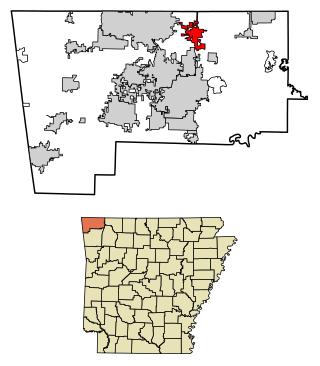
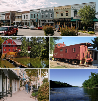
Pea Ridge is a city in Benton County, Arkansas, United States. The name Pea Ridge is derived from a combination of the physical location of the original settlement of the town, across the crest of an Ozark Mountains ridge, and for the hog peanuts or turkey peas that had been originally cultivated by Native American tribes centuries before European settlement, which later helped to provide basic subsistence once those pioneer settlers arrived.
Rogers is a city in Benton County, Arkansas, United States. Located in the Ozarks, it is part of the Northwest Arkansas region, one of the fastest growing metro areas in the country. Rogers was the location of the first Walmart store, whose corporate headquarters is located in neighboring Bentonville. Daisy Outdoor Products, known for its air rifles, has both its headquarters and its Airgun Museum in Rogers.
Pea Ridge is the name of several places in the United States of America that include:
DeWitt School District No. 1 is a school district based in the town of DeWitt, Arkansas, United States. The DeWitt School District is geographically the state's largest school district with 872.29 square miles (2,259.2 km2) of land and 46.18 square miles (119.6 km2) of water, encompassing portions of Arkansas and Jefferson, and Desha counties.

Highway 72 is a designation for two east–west state highways in Benton County, Arkansas. A western route of 26.32 miles (42.36 km) runs east from Highway 43 at Maysville to U.S. Route 71B (US 71B) in Bentonville. A second route of 12.67 miles (20.39 km) begins at Interstate 49/US Route 71 (I-49/US 71) in Bentonville and runs northeast to US 62 near Avoca. The route is one of the original Arkansas state highways.

Highway 265 is a designation for three state highways in Northwest Arkansas. The southern segment of 19.70 miles (31.70 km) runs from Highway 170 near Strickler north to I-49/US 71/Highway 112 in south Fayetteville. A second segment begins in east Fayetteville at Highway 16 and runs north through Springdale to Highway 94 in Rogers. Further north, a third segment of 3.324 miles (5.349 km) runs from Highway 94 in Pea Ridge north to the Missouri state line. The highways are maintained by the Arkansas Department of Transportation (ARDOT).
Highway 980 is a state highway designation for all state maintained airport roads in Arkansas.

U.S. Route 62 is a U.S. highway running from El Paso, Texas northeast to Niagara Falls, New York. In the U.S. state of Arkansas, the route runs 329.9 miles from the Oklahoma border near Summers east to the Missouri border in St. Francis, serving the northern portion of the state. The route passes through several cities and towns, including Fayetteville, Springdale, Bentonville, Harrison, Mountain Home, Pocahontas, and also Piggott. US 62 runs concurrent with several highways in Arkansas including Interstate 49 and U.S. Route 71 between Fayetteville and Bentonville, U.S. Route 412 through much of the state, U.S. Route 65 in the Harrison area, and with U.S. Route 63 and U.S. Route 67 in northeast Arkansas.

Highway 351 is a designation for two state highways in Northeast Arkansas. One route 0.92 miles (1.48 km) in Jonesboro begins at the Interstate 555/US Highway 63 (I-555/US 63) frontage road and runs north to Highway 18 as Industrial Drive. A second route of 13.87 miles (22.32 km) begins at Airport Road and runs north to Highway 358. Between Jonesboro and the northern terminus, the route is designated as part of the Crowley's Ridge Parkway, a National Scenic Byway, and two Civil War trails under the Arkansas Heritage Trails System. Both routes are maintained by the Arkansas State Highway and Transportation Department (AHTD).

Rohwer, Arkansas is an unincorporated community in Desha County, Arkansas, United States. The community is located on Arkansas Highway 1.
Kelso is an unincorporated community in Desha County, Arkansas, United States. The community is located at the intersection of Arkansas Highway 1 and Arkansas Highway 138.
Back Gate, Arkansas is an unincorporated community in Desha County, Arkansas, United States. The community is located at the junction of U.S. Route 165 and Arkansas Highway 1.
The Times of Northeast Benton County is a weekly newspaper with a 1,300–1,400 circulation located in Pea Ridge, Arkansas, located in the northeast corner of Benton County. In addition to the city of Pea Ridge, the newspaper covers the communities of Little Flock to the south, Avoca and Brightwater to the southeast, Garfield, Lost Bridge and Gateway to the east, and historically — though intermittently in recent years — Jacket and Mountain to the north in Missouri. Annette Beard, a resident of the area for more than 30 years, is the current managing editor of the newspaper.

Arkansas Highway 35 is a northwest–southeast state highway in southeast Arkansas. The route runs 115.83 miles (186.41 km) from Dewey near the Mississippi River northwest to Arkansas Highway 5 in Benton.
Desha is an unincorporated community and census-designated place (CDP) in Independence County, Arkansas, United States. It was first listed as a CDP in the 2020 census with a population of 715.
DeWitt High School is a comprehensive public high school located in De Witt, Arkansas, United States. The school provides secondary education for students in grades 9 through 12. DeWitt is one of two public high schools in Arkansas County, Arkansas and the sole high school administered by the DeWitt School District.
Pea Ridge High School is a comprehensive public high school located in the fringe town of Pea Ridge, Arkansas, United States. The school provides secondary education for students in grades kindergarten through 12. It is one of nine public high schools in Benton County, Arkansas and the sole high school administered by the Pea Ridge School District.

Arkansas Highway 44 is the designation for a state highway in the U.S. state of Arkansas. The highway is located in Far Eastern Arkansas and is split into two sections, both of which run close to the Mississippi, St. Francis and L'Anguille rivers. The first and longest section begins at the unincorporated community of Snow Lake in far northern Desha County and ends at AR 20 in Helena-West Helena. The second section begins at County Road 239 (CR 239) in Lee County, in the St. Francis National Forest, and ends at AR 1B in Marianna. AR 44 is part of the Great River Road and Crowley's Ridge Parkway.

