
Desha County is a county located in the southeast part of the U.S. state of Arkansas, with its eastern border the Mississippi River. At the 2020 census, the population was 11,395. The county seat is Arkansas City.

Arkansas City is a town in Desha County, Arkansas, United States. The population was 376 at the 2010 census. The town is the county seat of Desha County. Arkansas City Commercial District, located at Desoto Avenue and Sprague Street, is listed on the National Register of Historic Places.

Dumas is a city in Desha County, Arkansas, United States. The population was 4,706 at the 2010 census.

Tillar is a town in Desha and Drew counties in the U.S. state of Arkansas. The population was 225 at the 2010 census. The area west of it was known as Tillar Station. Frank Tillar Memorial Methodist Episcopal Church, South is listed on the National Register of Historic Places.

Watson is a city in Desha County, Arkansas, United States. The population was 211 at the 2010 census.
DeWitt School District No. 1 is a school district based in the town of DeWitt, Arkansas, United States. The DeWitt School District is geographically the state's largest school district with 872.29 square miles (2,259.2 km2) of land and 46.18 square miles (119.6 km2) of water, encompassing portions of Arkansas and Jefferson, and Desha counties.

The Jerome War Relocation Center was a Japanese American internment camp located in southeastern Arkansas, near the town of Jerome in the Arkansas Delta. Open from October 6, 1942, until June 30, 1944, it was the last American concentration camp to open and the first to close. At one point it held as many as 8,497 detainees. After closing, it was converted into a holding camp for German prisoners of war. Today, few remains of the camp are visible, as the wooden buildings were taken down. The smokestack from the hospital incinerator still stands.

The Rohwer War Relocation Center was a World War II Japanese American concentration camp located in rural southeastern Arkansas, in Desha County. It was in operation from September 18, 1942, until November 30, 1945, and held as many as 8,475 Japanese Americans forcibly evacuated from California. Among the inmates, the notation "朗和" was sometimes applied. The Rohwer War Relocation Center Cemetery is located here, and was declared a National Historic Landmark in 1992.

Highway 1 is a north–south state highway in east Arkansas. The route of 159.88 miles (257.30 km) runs from US Route 278 (US 278) in McGehee north to Supplemental Route BB at the Missouri state line. One of the original 1926 state highways, Highway 1 has remained very close to its original routing. The highway contains an overlap of approximately 50 miles (80 km) with U.S. Route 49.

Highway 4 is a designation for two state highways in Arkansas. The western segment of 2.99 miles (4.81 km) runs from SH-4 at the Oklahoma state line and terminates in Cove. An eastern segment of 22.49 miles (36.19 km) begins at U.S. Route 278 (US 278) in McGehee and heads east to Arkansas City then north to Highway 1 before terminating. The two routes were formerly connected until a portion of approximately 230 miles (370 km) was redesignated US 278 in 1998. The eastern segment is part of the Great River Road.
The Elaine School District #30 was a school district headquartered in Elaine, Arkansas. Its territory is now within the Marvell-Elaine School District.
Dumas Public Schools is a school district headquartered in Dumas, Arkansas. It serves territory in Desha and Lincoln counties, including Dumas, Gould, Mitchellville, and Winchester. It also serves Arkansas Department of Corrections prison property.
Paron is an unincorporated community in Saline County, Arkansas, United States. Paron is located along Arkansas Highway 9, 17.5 miles (28.2 km) northwest of Benton. Paron has a post office with ZIP code 72122.
McGehee School District is a public school district headquartered in McGehee, Arkansas. The school district encompasses 499.14 square miles (1,292.8 km2) of land, in Drew and Desha counties.
The Arkansas City School District was a school district of Arkansas City, Arkansas. Its territory is now in the McGehee School District.
The Delta Special School District was a school district of Rohwer, unincorporated Desha County, Arkansas, USA. Its territory is now in the McGehee School District. It also included Watson.

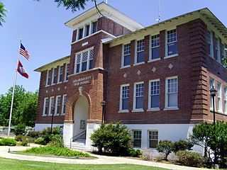
The Arkansas City High School was a comprehensive public high school serving students between 1910 and 2004 in Arkansas City, Arkansas, United States. Since 2005, the original 1910 building, which is listed on the National Register of Historic Places, has served as an annex of the neighboring Desha County Courthouse. It was a part of the Arkansas City School District.
The Japanese American Internment Museum, also known as the WWII Japanese American Internment Museum and the Jerome-Rohwer Interpretive Museum & Visitor Center, is a history museum in McGehee, Arkansas. The museum features exhibits regarding the area history of Japanese American internment in the 1940s when more than 17,000 Japanese Americans were housed at nearby Rohwer War Relocation Center and Jerome War Relocation Center during World War II. Exhibits include a film, oral histories, photographs, personal artifacts and some art made by internees, as well as changing art exhibitions. The museum also has started a library that lends books to people about the Japanese American experience.
Halley is an unincorporated community and census-designated place (CDP) in Desha County, Arkansas, United States. It was first listed as a CDP in the 2020 census with a population of 44.
Desha-Drew School District was a school district in Desha County and Drew County in Arkansas, with the administration in Desha County.


