Millwood State Park

Last updated
Millwood State Park
Arkansas state park
Country United States
State Arkansas
Regions South Arkansas
County Little River
City Ashdown
Coordinates 33°40′39″N93°59′14″W / 33.67750°N 93.98722°W / 33.67750; -93.98722 Coordinates: 33°40′39″N93°59′14″W / 33.67750°N 93.98722°W / 33.67750; -93.98722
Opened April 1, 1976
Management Arkansas Department of Parks and Tourism
Website: Millwood Lake State Park

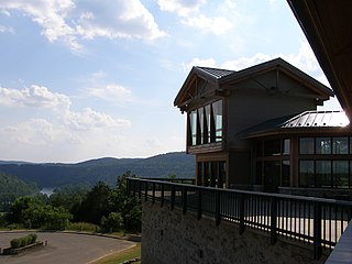
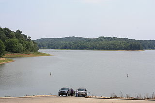
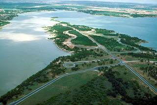
Millwood State Park is located just outside Ashdown, Arkansas, in Little River County in southwest Arkansas. Known for its excellent fishing and wildlife habitats, [1] [2] the park was established about a decade after the U.S. Army Corps of Engineers built 29,500-acre Millwood Lake north of Texarkana in Miller County. Held in place by a 3.3-mile-long earthen dam (the longest of its type in Arkansas), the lake’s trademark timber stands have made it a bass-fishing haven by providing cover vegetation and a food source that keep the fish in shallow, more accessible water.

Ashdown, Arkansas City in Arkansas, United States

Ashdown is a city in Little River County, Arkansas, United States. The community was incorporated in 1892 and has been the county seat since 1906. Located within the Arkansas Timberlands between the Little River and the Red River, Ashdown's economy and development have historically been tied to the timber industry, a trend that continues to this day. Ashdown's population at the 2010 census was 4,723, a slight decrease from the 2000 census. The city's well-preserved history and proximity to outdoor recreation such as Millwood State Park draws tourists to the area. Although not within the Texarkana metropolitan area, the city's proximity to Texarkana impacts many areas of life in Ashdown.

Little River County, Arkansas County in the United States

Little River County is a county located on the southwest border of the U.S. state of Arkansas, bordering a corner with Texas and Oklahoma. As of the 2010 census, the population was 13,171. The county seat is Ashdown.

Arkansas State of the United States of America

Arkansas is a state in the southern region of the United States, home to over 3 million people as of 2018. Its name is of Siouan derivation from the language of the Osage denoting their related kin, the Quapaw Indians. The state's diverse geography ranges from the mountainous regions of the Ozark and the Ouachita Mountains, which make up the U.S. Interior Highlands, to the densely forested land in the south known as the Arkansas Timberlands, to the eastern lowlands along the Mississippi River and the Arkansas Delta.

The lake was built in 1966 on the Little River, some sixteen miles above its confluence with the Red River. In addition to the Little River, the Cossatot and Saline rivers also contribute to the lake.

Red River of the South major tributary of the Mississippi and Atchafalaya rivers in the southern United States

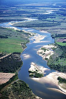
The Red River, or sometimes the Red River of the South, is a major river in the southern United States of America. It was named for the red-bed country of its watershed. It is one of several rivers with that name. Although it was once a tributary of the Mississippi River, the Red River is now a tributary of the Atchafalaya River, a distributary of the Mississippi that flows separately into the Gulf of Mexico. It is connected to the Mississippi River by the Old River Control Structure.

Cossatot River river in the United States of America

The Cossatot River is an 89-mile-long (143 km) river in Howard, Polk and Sevier counties in the U.S. state of Arkansas.

Among several recreational areas the Corps of Engineers established on the lake’s shoreline was Cypress Slough, at the southwestern end of Millwood Dam. On April 1, 1976, the Corps signed a lease agreement with the State Parks Division of the Arkansas Department of Parks and Tourism, and Cypress Slough became Millwood State Park. The site was chosen because of the important role the various lakes in the Little Red River basin play in controlling flooding on the Red River below Lake Texoma.

Lake Texoma reservoir on the border of the U.S. states of Texas and Oklahoma

Lake Texoma is one of the largest reservoirs in the United States, the 12th largest US Army Corps of Engineers' (USACE) lake, and the largest in USACE Tulsa District. Lake Texoma is formed by Denison Dam on the Red River in Bryan County, Oklahoma, and Grayson County, Texas, about 726 miles (1,168 km) upstream from the mouth of the river. It is located at the confluence of the Red and Washita Rivers. The project was completed in 1944. The damsite is about 5 miles (8.0 km) northwest of Denison, Texas, and 15 miles (24 km) southwest of Durant, Oklahoma. Lake Texoma is the most developed and most popular lake within the USACE Tulsa District, attracting around 6 million visitors a year. Oklahoma has more of the lake within its boundaries than Texas.

Due to the Corps of Engineers’ involvement, a combination of state and federal funds was used to expand the park’s facilities. Additional funding over the years has greatly improved the park. The lake and park take the name “Millwood” from a frontier river landing in the area, which was in use between 1845 and 1875.

The park offers camping, picnic sites, a pavilion, a marina, boat rentals, and hiking and bike trails. The park hosts several recreational events and interpretive activities, including fishing events, bird watching, lake tours, and family festivities.

Related Research Articles

Bull Shoals Lake

Bull Shoals Lake is an artificial lake or reservoir in the Ozark Mountains of northern Arkansas and southern Missouri. It has hundreds of miles of lake arms and coves, and common activities include boating, water sports, swimming, and fishing. Nineteen developed parks around the shoreline provide campgrounds, boat launches, swim areas, and marinas.

Beaver Lake (Arkansas) lake in Arkansas, United States

Beaver Lake is a man-made reservoir in the Ozark Mountains of Northwest Arkansas and is formed by a dam across the White River. Beaver Lake has some 487 miles (784 km) of shoreline. With towering limestone bluffs, natural caves, and a wide variety of trees and flowering shrubs, it is a popular tourist destination. Beaver Lake is the source of drinking water in Northwest Arkansas, which is managed, treated and sold by Beaver Water District.

Bull Shoals-White River State Park

Bull Shoals-White River State Park is a 732-acre (296 ha) Arkansas state park in Baxter and Marion Counties, Arkansas in the United States. Containing one of the nation's best trout-fishing streams, the park entered the system in 1955 after the United States Army Corps of Engineers built Bull Shoals Dam on the White River. The park runs along the shoreline of Bull Shoals Lake and the White River above and below the dam, and contains picnic areas, a marina, boat rentals, interpretive programs, and a visitors' center with gift shop.

Patoka Lake

Patoka Lake is the second-largest reservoir in the U.S. state of Indiana and is spread across Dubois, Crawford, and Orange counties in southern Indiana.

Dale Hollow Reservoir

The Dale Hollow Reservoir is a reservoir situated on the Kentucky/Tennessee border. The lake is formed by the damming of the Obey River, 7.3 miles (12 km) above its juncture with the Cumberland River at river mile 380. Portions of the lake also cover the Wolf River. Dale Hollow is one of four major flood control reservoirs for the Cumberland; the others being J. Percy Priest Dam, Wolf Creek Dam, and Center Hill Dam. It is also the site of Dale Hollow Lake State Park on the north (Kentucky) side.

Greers Ferry Lake

Greers Ferry Lake is the reservoir formed by Greers Ferry Dam, a United States Army Corps of Engineers dam in Northern Arkansas. It is located about 60 miles (100 km) north of Little Rock.

Walnut River (Kansas) river in the United States of America

The Walnut River is a tributary of the Arkansas River, 154 miles (248 km) long, in the Flint Hills region of Kansas in the United States. Via the Arkansas, it is part of the Mississippi River watershed.

Missouri National Recreational River protected area

The Missouri National Recreational River is a National Recreational River located on the border between Nebraska and South Dakota. The designation was first applied in 1978 to a 59-mile section of the Missouri River between Gavins Point Dam and Ponca State Park. In 1991, an additional 39-mile section between Fort Randall Dam and Niobrara, Nebraska, was added to the designation. These two stretches of the Missouri River are the only parts of the river between Montana and the mouth of the Missouri that remain undammed or unchannelized. The last 20 miles of the Niobrara River and 6 miles of Verdigre Creek were also added in 1991.

Millwood Lake is a reservoir in southwestern Arkansas, United States. It is located 9 miles (14 km) from Ashdown. The lake is formed from the damming of the point where the Little River and the Saline River meet.

Saline River (Little River tributary)

The Saline River is an 80-mile-long (130 km) tributary of the Little River in southwestern Arkansas in the United States. Via the Little and Red rivers, it is part of the watershed of the Mississippi River.

Lake Dardanelle lake of the United States of America

Lake Dardanelle is a major reservoir on the Arkansas River in Arkansas, USA. and is an integral part of the McClellan-Kerr Arkansas River Navigation System (MKARNS), which allows barge transportation from the Mississippi River to the Tulsa Port of Catoosa in northeastern Oklahoma. MKARNS went into service along its full length in 1971.

Sardis Lake (Mississippi) lake in the United States of America

Sardis Lake is a 98,520-acre (398.7 km2) reservoir on the Little Tallahatchie River in Lafayette, Panola, and Marshall counties, Mississippi. Sardis Lake is impounded by Sardis Dam, located nine miles (14 km) southeast of the town of Sardis. It is approximately an hour drive from Memphis, Tennessee. The dam is 15,300 feet (4,700 m) long, has an average height of 97 feet (30 m), and a maximum height of 117 feet (36 m).

Perry Lake (Kansas) lake in Kansas, United States

Perry Lake is a US Army Corps of Engineers operated reservoir in northeast Kansas. Its primary purposes are flood control, water reserve for nearby areas and regional recreation. The lake is approximately 11,150 acres (45 km²) in size, with over 160 miles of shoreline. Perry Lake's full multi-purpose pool elevation is 891.5 feet above sea level. Perry Lake is located about 40 miles west of Kansas City, just northwest of Lawrence, Kansas. Its close proximity to Kansas City, Lawrence, and the state capitol, Topeka, make it a very popular destination, with the nickname "Paradise on the Plains".

Proctor Lake U.S. Army Corps of Engineers reservoir along the Leon River located in Comanche County in the U.S. state of Texas

Proctor Lake is a U.S. Army Corps of Engineers reservoir along the Leon River located in Comanche County in the U.S. state of Texas. Around 3 miles (5 km) west of Proctor, Texas, USA. Proctor Lake Dam and the reservoir are managed by the Fort Worth District of the U.S. Army Corps of Engineers. The reservoir was officially impounded in 1963, and serves to provide flood control and drinking water for the communities downstream. Proctor Lake is a popular recreational destination.

Kerr Lake

Kerr Lake /kɑr/ is a reservoir along the border of the U.S. states of North Carolina and Virginia. It is impounded by the John H. Kerr Dam, constructed between 1947 and 1952 to produce hydroelectricity and to provide flood control. Kerr Lake is owned by the US Army Corps of Engineers, and is the largest reservoir in Virginia. It is located in parts of Vance, Granville, and Warren counties in North Carolina, and Mecklenburg, Charlotte, and Halifax counties in Virginia. At its maximum capacity, it is one of the largest reservoirs in the Southeastern United States, covering approximately 50,000 acres (200 km2) and bordered by over 850 miles (1,370 km) of shoreline. The lake is named for Congressman John H. Kerr of North Carolina, who supported the original creation of the lake.

Lake Red Rock (Des Moines River)

Lake Red Rock, also referred to as Red Rock Reservoir is a reservoir formed by Red Rock Dam on the Des Moines River, about 41 miles southeast of the city of Des Moines, Iowa, U.S.. The dam was completed in 1969 as a Flood control project by the United States Army Corps of Engineers, creating the largest lake in Iowa. The lake is essentially confined to Marion County. The damface is a few miles west and south of Pella, and similarly, a few miles northeast of Knoxville.

Hugo Lake

Hugo Lake is manmade lake located 7 miles (11 km) east of Hugo, in Choctaw County, Oklahoma, United States. It is formed by Hugo Lake Dam on the Kiamichi River 18 miles (29 km) upstream from the Red River. The dam is visible from U.S. Route 70, which crosses its spillway just west of Sawyer. Lake Hugo features approximately 110 miles (180 km) of shoreline and covers over 13,250 acres (53.6 km2), or 20 square miles (52 km2). Its normal pool elevation is 404.5 feet (123.3 m) above sea level and its normal storage capacity is 157,600 acre feet (194,400,000 m3). At flood stage its elevation is at 437.5 feet (133.4 m) above sea level and it is capable of storing 966,700 acre feet (1.1924×10⁹ m3) of flood waters. The lake's primary functions are to provide flood control, water storage, and recreational opportunities.

Little River (Red River tributary) river in Oklahoma and Arkansas, United States of America

The Little River is a tributary of the Red River, with a total length of 217 miles (349 km), 130 miles (210 km) in southeastern Oklahoma and 87 miles (140 km) in southwestern Arkansas. in southeastern Oklahoma and southwestern Arkansas in the United States. Via the Red, it is part of the watershed of the Mississippi River. Six large reservoirs impound the Little River and its tributaries. The drainage basin of the river totals 4,204 square miles (10,890 km2), 2,204 square miles (5,710 km2) in Oklahoma and 2,036 square miles (5,270 km2) in Arkansas. The Little River and its upper tributaries are popular for recreational canoeing and kayaking.

Pine Creek Lake is a lake in McCurtain County and Pushmataha County, Oklahoma, USA. It is 8 miles (13 km) north of Valliant, Oklahoma. It is located east of Rattan and north of Sobol.

References

  1. http://www.millwoodguideservice.com/ Millwood Lake Guide Service
  2. http://swtimes.com/sections/sports/fishing-again-strong-millwood-lake.html "Fishing again strong at Millwood Lake", Times Record, April 23, 2012