
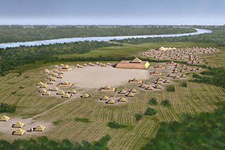
Wickliffe Mounds is a prehistoric, Mississippian culture archaeological site located in Ballard County, Kentucky, just outside the town of Wickliffe, about 3 miles (4.8 km) from the confluence of the Ohio and Mississippi rivers. Archaeological investigations have linked the site with others along the Ohio River in Illinois and Kentucky as part of the Angel Phase of Mississippian culture. Wickliffe Mounds is controlled by the State Parks Service, which operates a museum at the site for interpretation of the ancient community. Listed on the National Register of Historic Places, it is also a Kentucky Archeological Landmark and State Historic Site.

Letchworth Mounds Archaeological State Park is a 188.2 acre Florida State Park that preserves the state's tallest prehistoric, Native American ceremonial earthwork mound, which is 46 feet (14 m) high. It is estimated to have been built 1100 to 1800 years ago. This is one of three major surviving mound complexes in the Florida Panhandle. It is believed to have been built by the Weedon Island Culture, Native Americans who lived in North Florida. The hierarchical society planned and constructed massive earthwork mounds as expression of its religious and political system.
Spiro Mounds is an archaeological site located in present-day eastern Oklahoma that remains from an indigenous Indian culture that was part of the major northern Caddoan Mississippian culture. The 80-acre site is located within a floodplain on the southern side of the Arkansas River. The modern town of Spiro developed approximately seven miles to the south.

The Nodena Site is an archeological site east of Wilson, Arkansas and northeast of Reverie, Tennessee in Mississippi County, Arkansas, United States. Around 1400–1650 CE an aboriginal palisaded village existed in the Nodena area on a meander bend of the Mississippi River. The Nodena site was discovered and first documented by Dr. James K. Hampson, archaeologist and owner of the plantation on which the Nodena site is located. Artifacts from this site are on display in the Hampson Museum State Park in Wilson, Arkansas. The Nodena Site is the type site for the Nodena Phase, believed by many archaeologists to be the province of Pacaha visited by Spanish explorer Hernando de Soto in 1542.

The Eaker Site (3MS105) is an archaeological site on Eaker Air Force Base near Blytheville, Arkansas that was declared a National Historic Landmark in 1996. The site is the largest and most intact Late Mississippian Nodena Phase village site within the Central Mississippi Valley, with archaeological evidence indicating a palisaded village some 50 acres (20 ha) in size, with hundreds of structures. The site's major period of occupation was 1350–1450 CE, although evidence of occupation dates back to 600 CE. The site is also hypothesized to have been occupied by the Quapaw prior to a migration further south, after which they made contact with Europeans in the late 17th century.

The Menard-Hodges Site (3AR4), is an archaeological site in Arkansas County, Arkansas. It includes two large platform mounds as well as several house mounds. It is the type site for the Menard phase, a protohistoric Mississippian culture group.
Parkin Archeological State Park, also known as Parkin Indian Mound, is an archeological site and state park in Parkin, Cross County, Arkansas. Around 1350–1650 CE an aboriginal palisaded village existed at the site, at the confluence of the St. Francis and Tyronza rivers. Artifacts from this site are on display at the site museum. The Parkin Site is the type site for the Parkin phase, an expression of the Mississippian culture from the Late Mississippian period. Many archeologists believe it to be part of the province of Casqui, documented as visited by Spanish explorer Hernando de Soto in 1542. Archeological artifacts from the village of the Parkin people are dated to 1400–1650 CE.

Hampson Archeological Museum State Park is a 5-acre (2.0 ha) Arkansas state park in Mississippi County, Arkansas in the United States. The museum contains a collection of archeological artifacts from the Nodena Site, which is a former Native American village on the Mississippi River between 1400 and 1650. James K. Hampson began excavating the site in the 1920s, a museum was built in 1946 and the Arkansas General Assembly officially accepted the collection of artifacts from the Hampson family on March 30, 1957. The park first opened in 1961 as Hampson Museum State Park and has since been renamed.

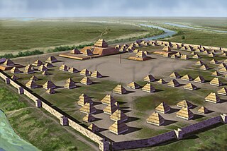
The Kincaid Mounds Historic Site c. 1050–1400 CE, is a Mississippian culture archaeological site located at the southern tip of present-day U.S. state of Illinois, along the Ohio River. Kincaid Mounds has been notable for both its significant role in native North American prehistory and for the central role the site has played in the development of modern archaeological techniques. The site had at least 11 substructure platform mounds, and 8 other monuments.
David G. Anderson is an archaeologist in the department of anthropology at the University of Tennessee, Knoxville, who specializes in Southeastern archaeology. His professional interests include climate change and human response, exploring the development of cultural complexity in Eastern North America, maintaining and improving the nation's Cultural Resource management (CRM) program, teaching and writing about archaeology, and developing technical and popular syntheses of archaeological research. He is the project director of the on-line Paleoindian Database of the Americas (PIDBA). and a Co-Director, with Joshua J. Wells, Eric C, Kansa, and Sarah Whitcher Kansa, of the Digital Index of North American Archaeology (DINAA)

The Baytown culture was a Pre-Columbian Native American culture that existed from 300 to 700 CE in the lower Mississippi River Valley, consisting of sites in eastern Arkansas, western Tennessee, Louisiana, and western Mississippi. The Baytown Site on the White River in Monroe County, Arkansas is the type site for culture. It was a Baytown Period culture during the Late Woodland period. It was contemporaneous with the Coastal Troyville and Troyville cultures of Louisiana and Mississippi and the Fourche Maline culture and was succeeded by the Plum Bayou culture. Where the Baytown peoples built dispersed settlements, the Troyville people instead continued building major earthwork centers.
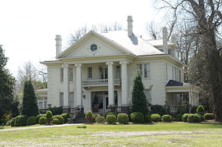
The Dortch Plantation, also known as the William P. Dortch House or the Marlsgate Plantation, is an historic house near Scott, Arkansas. Dortch House is the only plantation home in Arkansas that is fully furnished in the antebellum period style and available for tours and private events.

The Nodena Phase is an archaeological phase in eastern Arkansas and southeastern Missouri of the Late Mississippian culture which dates from about 1400–1650 CE. The Nodena Phase is known from a collection of villages along the Mississippi River between the Missouri Bootheel and Wapanocca Lake. They practiced extensive maize agriculture and artificial cranial deformation and were members of a continent wide trade and religious network known as the Southeastern Ceremonial Complex, which brought chert, whelk shells, and other exotic goods to the area.

Poverty Point State Historic Site/Poverty Point National Monument is a prehistoric earthwork constructed by the Poverty Point culture. The Poverty Point site is located in present-day northeastern Louisiana though evidence of the Poverty Point culture extends throughout much of the Southeastern Woodlands. The culture extended 100 miles (160 km) across the Mississippi Delta and south to the Gulf Coast. The Poverty Point site has been designated as a state historic site, U.S. National Monument, a U.S. National Historic Landmark, and UNESCO World Heritage Site. Located in the Southern United States, the site is 15.5 miles (24.9 km) from the current flow of the Mississippi River, and is situated on the edge of Macon Ridge, near the village of Epps in West Carroll Parish, Louisiana.
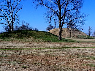
Plum Bayou culture is a Pre-Columbian Native American culture that lived in what is now east-central Arkansas from 650–1050 CE, a time known as the Late Woodland Period. Archaeologists defined the culture based on the Toltec Mounds site and named it for a local waterway.
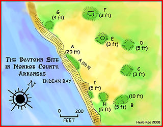
The Baytown Site is a Pre-Columbian Native American archaeological site located on the White River at Indian Bay, in Monroe County, Arkansas. It was first inhabited by peoples of the Baytown culture and later briefly by peoples of the Plum Bayou culture, in a time known as the Late Woodland period. It is considered the type site of the Baytown culture.
The Hayes site is an archaeological site located next to Bayou Meto in Arkansas County, Arkansas. It was inhabited by peoples of the Plum Bayou culture, in a time known as the Late Woodland period.

The Coy Site is an archaeological site located next to Indian-Bakers Bayou in Lonoke County, Arkansas. It was inhabited by peoples of the Plum Bayou culture, in a time known as the Late Woodland period. The site was occupied between 700 and 1000 CE. It was listed on the National Register of Historic Places in 1995.
The Roland Site is an archaeological site located on Dry Lake, an extinct channel of the White River in Arkansas County, Arkansas. It was inhabited intermittently from the beginning of the common era to late prehistoric times, but its most intensive inhabitation was by peoples of the Plum Bayou culture, in a time known as the Late Woodland period.


