The Cheyenne are one of the indigenous people of the Great Plains whose language is of the Algonquian language family. The Cheyenne comprise two Native American tribes, the Só'taeo'o or Só'taétaneo'o and the Tsétsêhéstâhese. These tribes merged in the early 19th century. Today, the Cheyenne people are split into two federally recognized Nations: the Southern Cheyenne, who are enrolled in the Cheyenne and Arapaho Tribes in Oklahoma, and the Northern Cheyenne, who are enrolled in the Northern Cheyenne Tribe of the Northern Cheyenne Indian Reservation in Montana.

Tulsa County is a county located in the U.S. state of Oklahoma. As of the 2010 census, the population was 603,403, making it the second-most populous county in Oklahoma, behind only Oklahoma County. Its county seat and largest city is Tulsa, the second-largest city in the state. Founded at statehood, in 1907, it was named after the previously established city of Tulsa. Before statehood, the area was part of both the Creek Nation and the Cooweescoowee District of Cherokee Nation in Indian Territory.

Rogers County is a county located in the northeastern part of the U.S. state of Oklahoma. As of the 2010 census, the population was 86,905, making it the sixth-largest county in Oklahoma based on population. Its county seat is Claremore. Rogers County is included in the Tulsa, OK Metropolitan Statistical Area.

Latimer County is a county located in the southeastern part of the U.S. state of Oklahoma. Its county seat is Wilburton. As of the 2010 census, the population was 11,154. The county was created at statehood in 1907 and named for James L. Latimer, a delegate from Wilburton to the 1906 state Constitutional Convention. Prior to statehood, it had been for several decades part of Gaines County, Sugar Loaf County, and Wade County in the Choctaw Nation.

Custer County is a county located in the U.S. state of Oklahoma. As of the 2010 census, the population was 27,469. Its county seat is Arapaho. The county was named in honor of General George Armstrong Custer.

Scouting in Arkansas has a long history, from 1913 to the present day, serving thousands of youth in programs that suit the environment in which they live.

Broken Arrow is a city located in the northeastern part of the U.S. state of Oklahoma, primarily in Tulsa County, with a portion in western Wagoner County. It is the largest suburb of Tulsa. According to the 2010 census, Broken Arrow has a population of 98,850 residents and is the fourth-largest city in the state. However, a July 2019 estimate reported that the population of the city is just under 112,000, making it the 280th-largest city in the United States. The city is part of the Tulsa Metropolitan Area, which has a population of 961,561 residents.

The term "Five Civilized Tribes" derives from the colonial and early federal period in the history of the United States. It refers to five Native American nations—the Cherokee, Chickasaw, Choctaw, Creek (Muscogee), and Seminole. These are the first five tribes that European Americans generally considered to be "civilized". Examples of colonial attributes adopted by these five tribes, which led European Americans to label them civilized, include Christianity, centralized governments, literacy in English, market participation, written constitutions, intermarriage with white Americans, and plantation slavery practices. The Five Civilized Tribes tended to maintain stable political relations with the European Americans.

The Ozarks, also known as the Ozark Mountains or Ozark Plateau, is a physiographic region in the U.S. states of Missouri, Arkansas, Oklahoma and the extreme southeastern corner of Kansas. The Ozarks cover a significant portion of northern Arkansas and most of the southern half of Missouri, extending from Interstate 40 in central Arkansas to Interstate 70 in central Missouri.

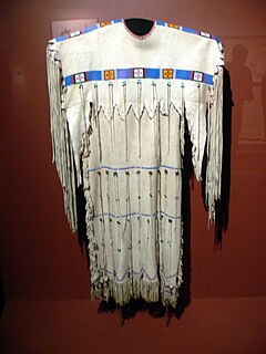
The Caddo Nation is a confederacy of several Southeastern Native American tribes. Their ancestors historically inhabited much of what is now East Texas, Louisiana, and portions of southern Arkansas and Oklahoma. They were descendants of the Caddoan Mississippian culture that constructed huge earthwork mounds at several sites in this territory, beginning about 800 CE. In the early 19th century, Caddo people were forced to a reservation in Texas; they were removed to Indian Territory in 1859.
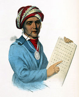
Sequoyah (c.1770–1843), was a Native American polymath of the Cherokee Nation. In 1821 he completed his independent creation of a Cherokee syllabary, making reading and writing in Cherokee possible. His achievement was one of the few times in recorded history that a member of a pre-literate people created an original, effective writing system..

The Cimarron River extends 698 miles (1,123 km) across New Mexico, Oklahoma, Colorado, and Kansas. The headwaters flow from Johnson Mesa west of Folsom in northeastern New Mexico. Much of the river's length lies in Oklahoma, where it either borders or passes through eleven counties. There are no major cities along its route. The river enters the Oklahoma Panhandle near Kenton, Oklahoma, crosses the southeastern corner of Colorado into Kansas, reenters the Oklahoma Panhandle, reenters Kansas, and finally returns to Oklahoma where it joins the Arkansas River at Keystone Reservoir west of Tulsa, Oklahoma, its only impoundment. The Cimarron drains a basin that encompasses about 18,927 square miles (49,020 km2).
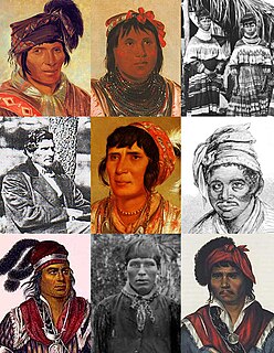
Indigenous peoples of the Southeastern Woodlands, Southeastern cultures, or Southeast Indians are an ethnographic classification for Native Americans who have traditionally inhabited the area now part of the Southeastern United States and the northeastern border of Mexico, that share common cultural traits. This classification is a part of the Eastern Woodlands. The concept of a southeastern cultural region was developed by anthropologists, beginning with Otis Mason and Frank Boas in 1887. The boundaries of the region are defined more by shared cultural traits than by geographic distinctions. Because the cultures gradually instead of abruptly shift into Plains, Prairie, or Northeastern Woodlands cultures, scholars do not always agree on the exact limits of the Southeastern Woodland culture region. Shawnee, Powhatan, Waco, Tawakoni, Tonkawa, Karankawa, Quapaw, and Mosopelea are usually seen as marginally southeastern and their traditional lands represent the borders of the cultural region.

During the American Civil War, most of what is now the U.S. state of Oklahoma was designated as the Indian Territory. It served as an unorganized region that had been set aside specifically for Native American tribes and was occupied mostly by tribes which had been removed from their ancestral lands in the Southeastern United States following the Indian Removal Act of 1830. As part of the Trans-Mississippi Theater, the Indian Territory was the scene of numerous skirmishes and seven officially recognized battles involving both Native American units allied with the Confederate States of America and Native Americans loyal to the United States government, as well as other Union and Confederate troops.
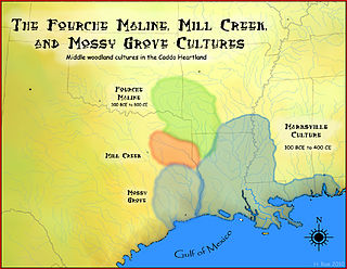
The Fourche Maline culture was a Woodland Period Native American culture that existed from 300 BCE to 800 CE, in what are now defined as southeastern Oklahoma, southwestern Arkansas, northwestern Louisiana, and northeastern Texas. They are considered to be one of the main ancestral groups of the Caddoan Mississippian culture, along with the contemporaneous Mill Creek culture of eastern Texas. This culture was named for the Fourche Maline Creek, a tributary of the Poteau River. Their modern descendants are the Caddo Nation of Oklahoma.
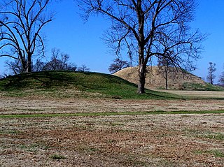
Plum Bayou culture is a Pre-Columbian Native American culture that lived in what is now east-central Arkansas from 650—1050 CE, a time known as the Late Woodland Period. Archaeologists defined the culture based on the Toltec Mounds site and named it for a local waterway.

Franktown Cave is located 25 miles south of Denver, Colorado on the north edge of the Palmer Divide. It is the largest rock shelter documented on the Palmer Divide, which contains artifacts from many prehistoric cultures. Prehistoric hunter-gatherers occupied Franktown Cave intermittently for 8000 years beginning about 6400 B.C. The site held remarkable lithic and ceramic artifacts, but it is better known for its perishable artifacts, including animal hides, wood, fiber and corn. Material goods were produced for their comfort, task-simplification and religious celebration. There is evidence of the site being a campsite or dwelling as recent as AD 1725.

The Trinchera Cave Archeological District (5LA9555) is an archaeological site in Las Animas County, Colorado with artifacts primarily dating from 1000 BC to AD 1749, although there were some Archaic period artifacts found. The site was added to the National Register of Historic Places in 2001 and is located on State Trust Lands.

The following outline is provided as an overview of and topical guide to the prehistoric people of Colorado, which covers the period of when Native Americans lived in Colorado prior to contact with the Domínguez–Escalante expedition in 1776. People's lifestyles included nomadic hunter-gatherering, semi-permanent village dwelling, and residing in pueblos.

Calf Creek Township is one of fifteen current townships in Searcy County, Arkansas, USA. As of the 2010 census, its total population was 326.


