A petroglyph is an image created by removing part of a rock surface by incising, picking, carving, or abrading, as a form of rock art. Outside North America, scholars often use terms such as "carving", "engraving", or other descriptions of the technique to refer to such images. Petroglyphs, estimated to be 20,000 years old are classified as protected monuments and have been added to the tentative list of UNESCO's World Heritage Sites. Petroglyphs are found worldwide, and are often associated with prehistoric peoples. The word comes from the Greek prefix petro-, from πέτρα petra meaning "stone", and γλύφω glýphō meaning "carve", and was originally coined in French as pétroglyphe.

Winnemucca Lake is a dry lake bed in northwest Nevada that features the oldest known petroglyphs in North America. Located astride the border between Washoe and Pershing counties, it was a shallow lake until the 1930s, but was dried when a dam and a road were built that combined to restrict and block water flow. It was formerly designated as a National Wildlife Refuge, but its status as a refuge was removed due to the lack of water.

In archaeology, rock art is human-made markings placed on natural surfaces, typically vertical stone surfaces. A high proportion of surviving historic and prehistoric rock art is found in caves or partly enclosed rock shelters; this type also may be called cave art or parietal art. A global phenomenon, rock art is found in many culturally diverse regions of the world. It has been produced in many contexts throughout human history. In terms of technique, the four main groups are:

The Spirit Cave mummy is the oldest human mummy found in North America. It was discovered in 1940 in Spirit Cave, 13 miles (21 km) east of Fallon, Nevada, United States, by the husband-and-wife archaeological team of Sydney and Georgia Wheeler. He was said to be forty years old when he died. Analysis of the remains showed similarities to North and South American indigenous peoples and in 2016, the remains were repatriated to the Fallon Paiute-Shoshone Tribe of Nevada. The Spirit Cave mummy was one of the first to be dated using accelerated mass spectrometer radiocarbon dating. In turn, its discovery and analysis gave much insight and motivation of further research into the chronology of the western great basin.

Sydney rock engravings, or Sydney rock art, are a form of Australian Aboriginal rock art in the sandstone around Sydney, New South Wales, Australia, that consist of carefully drawn images of people, animals, or symbols. Many thousands of such engravings are known to exist in the Sydney region, although the locations of most are not publicised to prevent damage by vandalism, and to retain their sanctity, as they are still regarded as sacred sites by Indigenous Australians. There are two art environments in Sydney Basin, rock shelters and engraving sites.

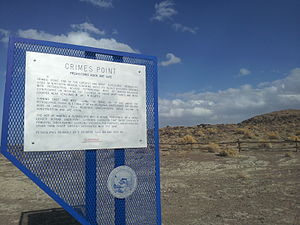
The Grapevine Canyon Petroglyphs are located in Grapevine Canyon on Spirit Mountain near Laughlin, Nevada, and are listed on the United States National Register of Historic Places. The area is also known as Christmas Tree Pass. While the petroglyphs extend through the canyon, a significant concentration lies at the entrance to the canyon which is at an elevation of 2,395 feet (730 m). The area features over 700 petroglyphs and many rock shelters.
Alanah Woody was an American archeologist, anthropologist, professor and executive director of the Nevada Rock Art Foundation. She was considered an expert in Native American rock art, such as pictographs and petroglyphs, especially in Nevada, and championed their protection.

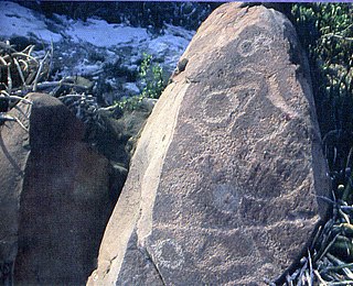
Coso Rock Art District is a rock art site containing over 100,000 Petroglyphs by Paleo-Indians and/or Native Americans. The district is located near the towns of China Lake and Ridgecrest, California. Big and Little Petroglyph Canyons were declared a National Historic Landmark in 1964. In 2001, they were incorporated into this larger National Historic Landmark District. There are several other distinct canyons in the Coso Rock Art District besides the Big and Little Petroglyph Canyons. Also known as Little Petroglyph Canyon and Sand Tanks, Renegade Canyon is but one of several major canyons in the Coso Range, each hosting thousands of petroglyphs. The majority of the Coso Range images fall into one of six categories: bighorn sheep, entopic images, anthropomorphic or human-like figures, other animals, weapons & tools, and "medicine bag" images. Scholars have proposed a few potential interpretations of this rock art. The most prevalent of these interpretations is that they could have been used for rituals associated with hunting.

Gatecliff Rockshelter (26NY301) is a major archaeological site in the Great Basin area of the western United States that provides remarkable stratigraphy; it has been called the "deepest archaeological rock shelter in the Americas". Located in Mill Canyon of the Toquima Range in the Monitor Valley of central Nevada, Gatecliff Rockshelter has an elevation of 7,750 feet (2,360 m). David Hurst Thomas discovered Gatecliff Rockshelter in 1970 and began excavations in 1971. Full scale excavations occurred at Gatecliff Rockshelter for about seven field seasons in which nearly 33 feet (10 m) of sediments were exposed for a well-defined stratigraphic sequence. The well-preserved artifacts and undisturbed sediments at Gatecliff Rockshelter provides data and information have been applied to a range of research topics. Based on the analysis of the artifacts at Gatecliff Rockshelter, it can be determined that it was most likely a short-term field camp throughout prehistory. The latest evidence for human usage at Gatecliff occurs between ca. 5500 B.P. to 1250 B.P.

Weepah Spring Wilderness is a 51,480-acre (20,830 ha) wilderness area in Lincoln and Nye Counties, in the U.S. state of Nevada. The Wilderness lies approximately 35 miles (56 km) north of the town of Alamo and is administered by the U.S. Bureau of Land Management.

Chumash rock art is a genre of paintings on caves, mountains, cliffs, or other living rock surfaces, created by the Chumash people of Southern California. Pictographs and petroglyphs are common through interior California, the rock painting tradition thrived until the 19th century. Chumash rock art is considered to be some of the most elaborate and plentiful rock art tradition in the region.

Martis is the name given by scientists to the group of Native Americans who lived in Northern California on both the eastern and western sides of the Sierra Nevada. The Martis complex lasted from 2000 BCE to 500 CE, during the Middle Archaic era. Evidence of Martis habitation has been found from Carson River and Reno, Nevada in the east to Auburn, California and Oroville, California in the west. The Martis name refers to the geographic region of Martis Creek which spans Nevada County, California and Placer County, California.
American Indian Rock Art in Minnesota MPS is a Multiple Property Submission (MPS) of the eligibility of many rock art properties for listing on the National Register of Historic Places. The listing is to protect and preserve Native American petroglyphs, pictographs and petroform rock art sites in the present day U.S. state of Minnesota.

The Barnesville Petroglyph petroglyph site in the eastern part of the U.S. state of Ohio. Located approximately 3 miles (4.8 km) southwest of the village of Barnesville in Belmont County, the petroglyphs have been known both by archaeologists and the general public since the 1850s or earlier. Although the site was significantly damaged during the twentieth century, it is still a significant archaeological site, and has been named a historic site.
Boca de Potrerillos is an archeological site located some 14 km from the municipal head of Mina, Nuevo León, México. About 60 km north east from Monterrey within the inter-sierra valleys of the Sierra Madre Oriental is the “mouth” or entrance to the Potrerillos Canyon between the Zorra and Antrisco hills. The site covers an area of about 6 km².
Lovelock Cave (NV-Ch-18) is a North American archaeological site previously known as Sunset Guano Cave, Horseshoe Cave, and Loud Site 18. The cave is about 150 feet (46 m) long and 35 feet (11 m) wide. Lovelock Cave is one of the most important classic sites of the Great Basin region because the conditions of the cave are conducive to the preservation of organic and inorganic material. The cave was placed on the National Register of Historic Places on May 24, 1984. It was the first major cave in the Great Basin to be excavated, and the Lovelock Cave people are part of the University of California Archaeological Community's Lovelock Cave Station.
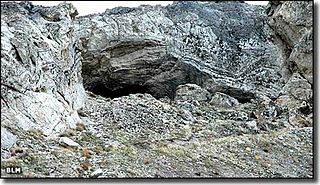
Hidden Cave is an archaeological cave site located in the Great Basin near Fallon, Nevada, United States. It got its name from Mark Harrington, who first excavated the cave and had a hard time finding the entrance, who said at the time, "This is one hidden cave!" It was excavated originally in the 1930s by Harrington and then excavated twice more before being returned to for the final time in 1978 by David Hurst Thomas for a more in depth excavation. The site dates back to the early Desert Archaic Culture from c. 4000 to 2000 years ago. Thousands of Archaic artifacts have been found here, and the site "provides important, if unusual clues about Desert Archaic lifeways". Hidden Cave was not lived in, but used as storage site for goods and tools for the 2000 years of its survival.

The Picture Rock Pass Petroglyphs Site is in northern Lake County, Oregon, United States. The site is located near the summit of Picture Rock Pass on land administered by the Bureau of Land Management. The designs were scraped into a basalt boulder by ancient Native Americans, probably between 7,500 and 12,000 years ago. No one knows the meaning of the petroglyph designs. Because of its unique archaeological and cultural significance, the Picture Rock Pass Petroglyph Site was listed on the National Register of Historic Places in 1975.
Bear Spirit Mountain is a Pleistocene Era American Indian ceremonial site also known as Great Serpent Mountain, located in the Eastern Panhandle of West Virginia that was discovered in 2016 by Matthew "Massaw" Howard. The site is referred to as Adonvdo Yona in Cherokee which means Bear Spirit.

The Taino were the indigenous people of the Caribbean and the principal inhabitants of Cuba, the Dominican Republic, Haiti, Jamaica, and Puerto Rico. Caribbean archaeologists have theorized that by the mid 16th century the native people of the Caribbean were extinct. However, the story of Taino extinction may not be the case according to recent research and archaeological findings.