Wave-cut platform

Last updated
Wave-cut platform at Southerndown, South Wales, UK Wavecut platform southerndown pano.jpg
Wave-cut platform at Southerndown, South Wales, UK

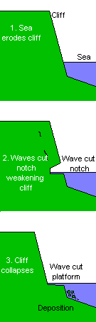
A wave-cut platform, shore platform, coastal bench, or wave-cut cliff is the narrow flat area often found at the base of a sea cliff or along the shoreline of a lake, bay, or sea that was created by erosion. Wave-cut platforms are often most obvious at low tide when they become visible as huge areas of flat rock. Sometimes the landward side of the platform is covered by sand, forming the beach, and then the platform can only be identified at low tides or when storms move the sand.

Contents

Formation

The formation of a wave-cut platform Wave cut platform.png
The formation of a wave-cut platform

Wave-cut platforms form when destructive waves hit against the cliff face, causing an undercut between the high and low water marks, mainly as a result of abrasion, corrosion and hydraulic action, creating a wave-cut notch. This notch then enlarges into a cave. The waves undermine this portion until the roof of the cave cannot hold due to the pressure and freeze-thaw or biological weathering acting on it, and collapses, resulting in the cliff retreating landward. The base of the cave forms the wave-cut platform as attrition causes the collapsed material to be broken down into smaller pieces, while some cliff material may be washed into the sea. This may be deposited at the end of the platform, forming an off-shore beach.

Because of the continual wave action, a wave-cut platform represents an extremely hostile environment and only certain organisms can utilize such a niche.

Use of ancient examples

Ancient wave-cut platforms provide evidence of past sea and lake levels. Raised and abandoned platforms, sometimes found behind modern beaches, are evidence of higher sea levels in the geological past, [1] and have been used to identify areas of isostatic adjustment. By using scientific dating methods, or examination of marine fossils found on the platform, it is possible to work out when the platform was formed, thus giving geographers and geologists information about sea levels at known times in the past. This has been used in the United Kingdom and other previously glaciated areas to calculate the rate at which land is rising now that it is no longer covered in ice.

Where the coastline itself is changing due to seismic action, there may be a series of platforms showing earlier sea levels and indicating the amount of uplift caused by various earthquakes.

Usage of term 'wave-cut'

According to Trenhaile, [2] Sunamura, [3] and Massalink and Hughes, [4] the term 'wave-cut platform' should no longer be used as it assumes that shore platforms are the result of wave action, which is not always true. Shore platforms, like comparable river and lake platforms, are erosional features that develop when removal of saprock and other debris by waves and currents leaves behind a bedrock surface below the water table. [5]

See also

Related Research Articles

<span class="mw-page-title-main">Coast</span> Area where land meets the sea or ocean

The coast, also known as the coastline, shoreline or seashore, is defined as the area where land meets the ocean, or as a line that forms the boundary between the land and the coastline. Shores are influenced by the topography of the surrounding landscape, as well as by water induced erosion, such as waves. The geological composition of rock and soil dictates the type of shore which is created. The Earth has around 620,000 kilometres (390,000 mi) of coastline. Coasts are important zones in natural ecosystems, often home to a wide range of biodiversity. On land, they harbor important ecosystems such as freshwater or estuarine wetlands, which are important for bird populations and other terrestrial animals. In wave-protected areas they harbor saltmarshes, mangroves or seagrasses, all of which can provide nursery habitat for finfish, shellfish, and other aquatic species. Rocky shores are usually found along exposed coasts and provide habitat for a wide range of sessile animals and various kinds of seaweeds. In physical oceanography, a shore is the wider fringe that is geologically modified by the action of the body of water past and present, while the beach is at the edge of the shore, representing the intertidal zone where there is one. Along tropical coasts with clear, nutrient-poor water, coral reefs can often be found between depths of 1–50 meters.

<span class="mw-page-title-main">Coastal erosion</span> Displacement of land along the coastline

Coastal erosion is the loss or displacement of land, or the long-term removal of sediment and rocks along the coastline due to the action of waves, currents, tides, wind-driven water, waterborne ice, or other impacts of storms. The landward retreat of the shoreline can be measured and described over a temporal scale of tides, seasons, and other short-term cyclic processes. Coastal erosion may be caused by hydraulic action, abrasion, impact and corrosion by wind and water, and other forces, natural or unnatural.

<span class="mw-page-title-main">Stack (geology)</span> Geological landform consisting of a steep and often vertical column or columns of rock

A stack or sea stack is a geological landform consisting of a steep and often vertical column or columns of rock in the sea near a coast, formed by wave erosion. Stacks are formed over time by wind and water, processes of coastal geomorphology. They are formed when part of a headland is eroded by hydraulic action, which is the force of the sea or water crashing against the rock. The force of the water weakens cracks in the headland, causing them to later collapse, forming free-standing stacks and even a small island. Without the constant presence of water, stacks also form when a natural arch collapses under gravity, due to sub-aerial processes like wind erosion. Erosion causes the arch to collapse, leaving the pillar of hard rock standing away from the coast—the stack. Eventually, erosion will cause the stack to collapse, leaving a stump. Stacks can provide important nesting locations for seabirds, and many are popular for rock climbing.

Landforms are categorized by characteristic physical attributes such as their creating process, shape, elevation, slope, orientation, rock exposure, and soil type.

<span class="mw-page-title-main">Raised beach</span> Emergent coastal landform

A raised beach, coastal terrace, or perched coastline is a relatively flat, horizontal or gently inclined surface of marine origin, mostly an old abrasion platform which has been lifted out of the sphere of wave activity. Thus, it lies above or under the current sea level, depending on the time of its formation. It is bounded by a steeper ascending slope on the landward side and a steeper descending slope on the seaward side. Due to its generally flat shape, it is often used for anthropogenic structures such as settlements and infrastructure.

<span class="mw-page-title-main">Coastal geography</span> Study of the region between the ocean and the land

Coastal geography is the study of the constantly changing region between the ocean and the land, incorporating both the physical geography and the human geography of the coast. It includes understanding coastal weathering processes, particularly wave action, sediment movement and weather, and the ways in which humans interact with the coast.

<span class="mw-page-title-main">Coastal management</span> Preventing flooding and erosion of shorelines

Coastal management is defence against flooding and erosion, and techniques that stop erosion to claim lands. Protection against rising sea levels in the 21st century is crucial, as sea level rise accelerates due to climate change. Changes in sea level damage beaches and coastal systems are expected to rise at an increasing rate, causing coastal sediments to be disturbed by tidal energy.

<span class="mw-page-title-main">Terrace (geology)</span> A step-like landform

In geology, a terrace is a step-like landform. A terrace consists of a flat or gently sloping geomorphic surface, called a tread, that is typically bounded on one side by a steeper ascending slope, which is called a "riser" or "scarp". The tread and the steeper descending slope together constitute the terrace. Terraces can also consist of a tread bounded on all sides by a descending riser or scarp. A narrow terrace is often called a bench.

<span class="mw-page-title-main">St Bees Head</span> Headland in cumbria

St Bees Head is a headland on the North West coast of the English county of Cumbria and is named after the nearby village of St Bees.

<span class="mw-page-title-main">Abrasion (geology)</span> Process of erosion

Abrasion is a process of erosion that occurs when material being transported wears away at a surface over time, commonly happens in ice and glaciers. The primary process of abrasion is physical weathering. Its the process of friction caused by scuffing, scratching, wearing down, marring, and rubbing away of materials. The intensity of abrasion depends on the hardness, concentration, velocity and mass of the moving particles. Abrasion generally occurs in four ways: glaciation slowly grinds rocks picked up by ice against rock surfaces; solid objects transported in river channels make abrasive surface contact with the bed and walls; objects transported in waves breaking on coastlines; and by wind transporting sand or small stones against surface rocks. Abrasion is the natural scratching of bedrock by a continuous movement of snow or glacier downhill. This is caused by a force, friction, vibration, or internal deformation of the ice, and by sliding over the rocks and sediments at the base that causes the glacier to move.

<span class="mw-page-title-main">Cuspate foreland</span> Geographical features found on coastlines and lakeshores

Cuspate forelands, also known as cuspate barriers or nesses in Britain, are geographical features found on coastlines and lakeshores that are created primarily by longshore drift. Formed by accretion and progradation of sand and shingle, they extend outwards from the shoreline in a triangular shape.

Beach evolution occurs at the shoreline where sea, lake or river water is eroding the land. Beaches exist where sand accumulated from centuries-old, recurrent processes that erode rocky and sedimentary material into sand deposits. River deltas deposit silt from upriver, accreting at the river's outlet to extend lake or ocean shorelines. Catastrophic events such as tsunamis, hurricanes, and storm surges accelerate beach erosion.

<span class="mw-page-title-main">Shingle beach</span> Beach which is armoured with pebbles or small- to medium-sized cobbles

A shingle beach, also known as either a cobble beach or gravel beach, is a commonly narrow beach that is composed of coarse, loose, well-rounded, and waterworn gravel, called shingle. The gravel (shingle) typically consists of smooth, spheroidal to flattened, pebbles, cobbles, and sometimes small boulders, generally in the 20 to 200 millimetres size range. Shingle beaches typically have a steep slope on both their landward and seaward sides. Shingle beaches form in wave-dominated locations where resistant bedrock cliffs provide gravel-sized rock debris. They are also found in high latitudes and temperate shores where the erosion of Quaternary glacial deposits provide gravel-size rock fragments. This term is most widely used in Great Britain.

<span class="mw-page-title-main">Coastal engineering</span> Branch of civil engineering

Coastal engineering is a branch of civil engineering concerned with the specific demands posed by constructing at or near the coast, as well as the development of the coast itself.

<span class="mw-page-title-main">Bench (geology)</span> Long, relatively narrow land bounded by distinctly steeper slopes above and below

In geomorphology, geography and geology, a bench or benchland is a long, relatively narrow strip of relatively level or gently inclined land that is bounded by distinctly steeper slopes above and below it. Benches can be of different origins and created by very different geomorphic processes.

<span class="mw-page-title-main">Geology of Cape Town</span> Geological formations and their history in the vicinity of Cape Town

Cape Town lies at the south-western corner of the continent of Africa. It is bounded to the south and west by the Atlantic Ocean, and to the north and east by various other municipalities in the Western Cape province of South Africa.

<span class="mw-page-title-main">Cliffed coast</span> Coast where waves have formed steep cliffs

A cliffed coast, also called an abrasion coast, is a form of coast where the action of marine waves has formed steep cliffs that may or may not be precipitous. It contrasts with a flat or alluvial coast.

<span class="mw-page-title-main">Flat coast</span> Shoreline where the land descends gradually into the sea

At a flat coast or flat shoreline, the land descends gradually into the sea. Flat coasts can be formed either as a result of the sea advancing into gently sloping terrain or through the abrasion of loose rock. They may be basically divided into two parallel strips: the shoreface and the beach.

<span class="mw-page-title-main">Coastal sediment transport</span>

Coastal sediment transport is the interaction of coastal land forms to various complex interactions of physical processes. The primary agent in coastal sediment transport is wave activity, followed by tides and storm surge, and near shore currents. Wind-generated waves play a key role in the transfer of energy from the open ocean to the coastlines. In addition to the physical processes acting upon the shore, the size distribution of the sediment is a critical determination for how the beach will change. These various interactions generate a wide variety of beaches.. Other than the interactions between coastal land forms and physical processes there is also the addition of modification of these landforms through anthropogenic sources. Some of the anthropogenic sources of modification have been put in place to halt erosion or prevent harbors from filling up with sediment. In order to assist community planners, local governments, and national governments a variety of models have been developed to predict the changes of beach sediment transport at coastal locations. Typically, during large wave events, the sediment gets transported off the beach face and deposited offshore generating a sandbar. Once the significant wave event has diminished, the sediment then gets slowly transported back onshore.

References

  1. Wilson, M.A., Curran, H.A. and White, B. 1998: Paleontological evidence of a brief global sea-level event during the last interglacial. Lethaia 31: 241-250. "Archived copy" (PDF). Archived from the original (PDF) on 2011-01-12. Retrieved 2009-10-28.{{cite web}}: CS1 maint: archived copy as title (link)
  2. Trenhaile, A. S. 1987: The Geomorphology of Rock Coasts. (Oxford University Press, Oxford, U.K.) 393 pp.
  3. Sunamura, T., 1992. Geomorphology of rocky coasts. New York: John Wiley.
  4. Masselink, G and Hughes, M. 2003. Introduction to Coastal Processes and Geomorphology. Hodder Arnold
  5. Retallack, G.J. and Roering, J.J. 2012: Wave-cut or water-table platforms of rocky coasts and rivers? GSA Today 22(6), 4-9.