
Limestone is a type of carbonate sedimentary rock which is the main source of the material lime. It is composed mostly of the minerals calcite and aragonite, which are different crystal forms of CaCO3. Limestone forms when these minerals precipitate out of water containing dissolved calcium. This can take place through both biological and nonbiological processes, though biological processes, such as the accumulation of corals and shells in the sea, have likely been more important for the last 540 million years. Limestone often contains fossils which provide scientists with information on ancient environments and on the evolution of life.

Sedimentary rocks are types of rock that are formed by the accumulation or deposition of sediments, ie. mineral or organic particles, at Earth's surface, followed by cementation. Sedimentation is the collective name for processes that cause these particles to settle in place. The particles that form a sedimentary rock are called sediment, and may be composed of geological detritus (minerals) or biological detritus. The geological detritus originated from weathering and erosion of existing rocks, or from the solidification of molten lava blobs erupted by volcanoes. The geological detritus is transported to the place of deposition by water, wind, ice or mass movement, which are called agents of denudation. Biological detritus was formed by bodies and parts of dead aquatic organisms, as well as their fecal mass, suspended in water and slowly piling up on the floor of water bodies. Sedimentation may also occur as dissolved minerals precipitate from water solution.

In oceanography, geomorphology, and geoscience, a shoal is a natural submerged ridge, bank, or bar that consists of, or is covered by, sand or other unconsolidated material, and rises from the bed of a body of water close to the surface or above it, which poses a danger to navigation. Shoals are also known as sandbanks, sandbars, or gravelbars. Two or more shoals that are either separated by shared troughs or interconnected by past or present sedimentary and hydrographic processes are referred to as a shoal complex.
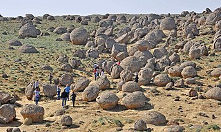
A concretion is a hard and compact mass formed by the precipitation of mineral cement within the spaces between particles, and is found in sedimentary rock or soil. Concretions are often ovoid or spherical in shape, although irregular shapes also occur. The word concretion is borrowed from Latin concretio'(act of) compacting, condensing, congealing, uniting', itself derived from concrescere'to thicken, condense, congeal', from con-'together' and crescere'to grow'.

Deposition is the geological process in which sediments, soil and rocks are added to a landform or landmass. Wind, ice, water, and gravity transport previously weathered surface material, which, at the loss of enough kinetic energy in the fluid, is deposited, building up layers of sediment.

Coquina is a sedimentary rock that is composed either wholly or almost entirely of the transported, abraded, and mechanically sorted fragments of mollusks, trilobites, brachiopods, or other invertebrates. The term coquina comes from the Spanish word for "cockle" and "shellfish".

Aeolian processes, also spelled eolian, pertain to wind activity in the study of geology and weather and specifically to the wind's ability to shape the surface of the Earth. Winds may erode, transport, and deposit materials and are effective agents in regions with sparse vegetation, a lack of soil moisture and a large supply of unconsolidated sediments. Although water is a much more powerful eroding force than wind, aeolian processes are important in arid environments such as deserts.

The Bimini Road, sometimes called the Bimini Wall, is an underwater rock formation near the island of North Bimini in the Bimini chain of islands. The Road consists of a 0.8 km (0.50 mi)-long northeast-southwest linear feature composed of roughly rectangular limestone blocks. Various claims have been made for this feature being either a wall, road, pier, breakwater, or other man-made structure. However, credible evidence or arguments are lacking for such an origin.
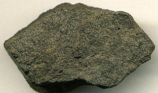
Phosphorite, phosphate rock or rock phosphate is a non-detrital sedimentary rock that contains high amounts of phosphate minerals. The phosphate content of phosphorite (or grade of phosphate rock) varies greatly, from 4% to 20% phosphorus pentoxide (P2O5). Marketed phosphate rock is enriched ("beneficiated") to at least 28%, often more than 30% P2O5. This occurs through washing, screening, de-liming, magnetic separation or flotation. By comparison, the average phosphorus content of sedimentary rocks is less than 0.2%.

Coastal geography is the study of the constantly changing region between the ocean and the land, incorporating both the physical geography and the human geography of the coast. It includes understanding coastal weathering processes, particularly wave action, sediment movement and weather, and the ways in which humans interact with the coast.

Clastic rocks are composed of fragments, or clasts, of pre-existing minerals and rock. A clast is a fragment of geological detritus, chunks, and smaller grains of rock broken off other rocks by physical weathering. Geologists use the term clastic to refer to sedimentary rocks and particles in sediment transport, whether in suspension or as bed load, and in sediment deposits.

A carbonate platform is a sedimentary body which possesses topographic relief, and is composed of autochthonic calcareous deposits. Platform growth is mediated by sessile organisms whose skeletons build up the reef or by organisms which induce carbonate precipitation through their metabolism. Therefore, carbonate platforms can not grow up everywhere: they are not present in places where limiting factors to the life of reef-building organisms exist. Such limiting factors are, among others: light, water temperature, transparency and pH-Value. For example, carbonate sedimentation along the Atlantic South American coasts takes place everywhere but at the mouth of the Amazon River, because of the intense turbidity of the water there. Spectacular examples of present-day carbonate platforms are the Bahama Banks under which the platform is roughly 8 km thick, the Yucatan Peninsula which is up to 2 km thick, the Florida platform, the platform on which the Great Barrier Reef is growing, and the Maldive atolls. All these carbonate platforms and their associated reefs are confined to tropical latitudes. Today's reefs are built mainly by scleractinian corals, but in the distant past other organisms, like archaeocyatha or extinct cnidaria were important reef builders.

A sabkha is a coastal, supratidal mudflat or sandflat in which evaporite-saline minerals accumulate as the result of semiarid to arid climate. Sabkhas are gradational between land and intertidal zone within restricted coastal plains just above normal high-tide level. Within a sabkha, evaporite-saline minerals sediments typically accumulate below the surface of mudflats or sandflats. Evaporite-saline minerals, tidal-flood, and aeolian deposits characterize many sabkhas found along modern coastlines. The accepted type locality for a sabkha is at the southern coast of the Persian Gulf, in the United Arab Emirates. Evidence of clastic sabkhas are found in the geological record of many areas, including the UK and Ireland. Sabkha is a phonetic transliteration of the Arabic word used to describe any form of salt flat. A sabkha is also known as a sabkhah,sebkha, or coastal sabkha.
Beach evolution is a natural process occurring along shorelines where sea, lake or river water erodes the land. Beaches form as sand accumulates over centuries through recurrent processes that erode rocky and sedimentary material into sand deposits. River deltas contribute by depositing silt carried from upriver, accreting at the river's outlet to extend lake or ocean shorelines. Catastrophic events such as tsunamis, hurricanes, and storm surges accelerate beach erosion.

Minerals bond grains of sediment together by growing around them. This process is called cementation and is a part of the rock cycle.
Shallow water marine environment refers to the area between the shore and deeper water, such as a reef wall or a shelf break. This environment is characterized by oceanic, geological and biological conditions, as described below. The water in this environment is shallow and clear, allowing the formation of different sedimentary structures, carbonate rocks, coral reefs, and allowing certain organisms to survive and become fossils.

The geology of Lebanon remains poorly studied prior to the Jurassic. The country is heavily dominated by limestone, sandstone, other sedimentary rocks, and basalt, defined by its tectonic history. In Lebanon, 70% of exposed rocks are limestone karst.

The geology of Senegal formed beginning more than two billion years ago. The Archean greenschist Birimian rocks common throughout West Africa are the oldest in the country, intruded by Proterozoic granites. Basins formed in the interior during the Paleozoic and filled with sedimentary rocks, including tillite from a glaciation. With the rifting apart of the supercontinent Pangaea in the Mesozoic, the large Senegal Basin filled with thick sequences of marine and terrestrial sediments. Sea levels declined in the Eocene forming large phosphate deposits. Senegal is blanketed in thick layers of terrestrial sediments formed in the Quaternary. The country has extensive natural resources, including gold, diamonds, and iron.

The geology of Virginia began to form at least 1.8 billion years ago. The oldest rocks in the state were metamorphosed during the Grenville orogeny, a mountain-building event beginning 1.2 billion years ago in the Proterozoic, which obscured older rocks. Throughout the Proterozoic and Paleozoic, Virginia experienced igneous intrusions, carbonate and sandstone deposition, and a series of other mountain-building events which defined the terrain of the inland parts of the state. The closing of the Iapetus Ocean formed the supercontinent Pangaea, and created additional small landmasses, some of which are now hidden beneath thick Atlantic Coastal Plain sediments. The region subsequently experienced the rifting open of the Atlantic ocean in the Mesozoic, the development of the Coastal Plain, isolated volcanism, and a series of marine transgressions that flooded much of the area. Virginia has extensive deposits of coal, oil, and natural gas, as well as deposits of other minerals and metals, including vermiculite, kyanite and uranium.

The Pancake Rocks and Blowholes are a coastal rock formation at Punakaiki on the West Coast of the South Island of New Zealand. They are a popular visitor attraction.


