Rock Hawk

Last updated
Photo from observation tower Rock Hawk, Putnam County, GA, US.jpg
Photo from observation tower

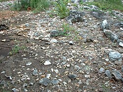
Rock Hawk Effigy Mound is an archaeological site in Putnam County, Georgia, United States. It consists of thousands of pieces of quartzite laid in the shape of a large bird. Although it is most often referred to as a hawk, scholars do not know exactly what type of bird the original builders intended to portray.

Only two such effigy mounds have been found east of the Mississippi River. The other, known as Rock Eagle, is also located in Putnam County, approximately thirteen miles to the northwest. ( 33°25.045′N83°23.288′W / 33.417417°N 83.388133°W / 33.417417; -83.388133 ) The physical condition of Rock Hawk is far below that of its 'sister' site. Viewers must use a degree of imagination to see a bird — let alone a hawk — in the remains. Scholars do not know if there was greater degradation of the Rock Hawk site, greater preservation or reconstruction at Rock Eagle (which is by far the more famous of the two and a greater 'attraction'), or a combination of these or other factors.

Current archaeology suggests that the site was built between 1,000 and 3,000 years ago by Woodland Indians. These Native Americans may have been part of the Adena or Hopewell cultures, although it is more likely that they represented a unique group.

To protect the site, access to the mound is prohibited, and it is surrounded by a tall fence. The Georgia Power company manages the area. It maintains an easily accessible parking area near the mound, as well as a network of hiking trails and other recreational amenities in the area. Visitors are permitted to visit the mound free of charge. The site is located along Wallace Dam Road, off State Route 16, several miles east of Eatonton, near the shores of the manmade Lake Oconee.

Coordinates: 33°20.693′N83°10.502′W / 33.344883°N 83.175033°W / 33.344883; -83.175033

Related Research Articles

<span class="mw-page-title-main">Putnam County, Georgia</span> County in Georgia, United States

Putnam County is a county located in the central portion of the U.S. state of Georgia. As of the 2020 census, the population was 22,047. The county seat is Eatonton.

<span class="mw-page-title-main">Effigy Mounds National Monument</span> National monument of prehistoric mounds built by Native Americans, in Iowa, United States

Effigy Mounds National Monument preserves more than 200 prehistoric mounds built by pre-Columbian Mound Builder cultures, mostly in the first millennium CE, during the later part of the Woodland period of pre-Columbian North America. Numerous effigy mounds are shaped like animals, including bears and birds.

<span class="mw-page-title-main">Eatonton, Georgia</span> City in Georgia, United States

Eatonton is a city in and county seat of Putnam County, Georgia, United States. As of the 2020 census, the city had a population of 6,307. It was named after William Eaton, an officer and diplomat involved in the First Barbary War. The name consists of his surname with the English suffix "ton," meaning "town".

<span class="mw-page-title-main">Hopewell tradition</span> Ancient North American indigenous civilization

The Hopewell tradition, also called the Hopewell culture and Hopewellian exchange, describes a network of precontact Native American cultures that flourished in settlements along rivers in the northeastern and midwestern Eastern Woodlands from 100 BCE to 500 CE, in the Middle Woodland period. The Hopewell tradition was not a single culture or society but a widely dispersed set of populations connected by a common network of trade routes.

<span class="mw-page-title-main">Serpent Mound</span> Prehistoric effigy mound in Ohio, United States

The Great Serpent Mound is a 1,348-foot-long (411 m), three-foot-high prehistoric effigy mound located in Peebles, Ohio. It was built on what is known as the Serpent Mound crater plateau, running along the Ohio Brush Creek in Adams County, Ohio. The mound is the largest serpent effigy in the world.

<span class="mw-page-title-main">Ocmulgee Mounds National Historical Park</span> National monument in the United States

Ocmulgee Mounds National Historical Park in Macon, Georgia, United States preserves traces of over ten millennia of culture from the Native Americans in the Southeastern Woodlands. Its chief remains are major earthworks built before 1000 CE by the South Appalachian Mississippian culture These include the Great Temple and other ceremonial mounds, a burial mound, and defensive trenches. They represented highly skilled engineering techniques and soil knowledge, and the organization of many laborers. The site has evidence of "12,000 years of continuous human habitation." The 3,336-acre (13.50 km2) park is located on the east bank of the Ocmulgee River. Macon, Georgia developed around the site after the United States built Fort Benjamin Hawkins nearby in 1806 to support trading with Native Americans.

<span class="mw-page-title-main">Tama-Re</span> Egyptian-themed compound of a religious sect in state of Georgia


The Tama-Re compound in Putnam County, Georgia was an Egyptian-themed set of buildings and monuments established in 1993 on 476 acres near Eatonton. It was founded by the Nuwaubian Nation, a religious movement that had a variety of esoteric beliefs and was led by Dwight D. York. That organisation started in 1967 in New York and went through many incarnations and name changes. In 1993, the group sold their property in Brooklyn, New York and moved to the site that would become Tama-Re.

<span class="mw-page-title-main">Lizard Mound State Park</span> United States historic place

Lizard Mound State Park is a state park in the Town of Farmington, Washington County, Wisconsin near the city of West Bend. Established in 1950, it was acquired by Washington County from the state of Wisconsin in 1986, and was returned to the state in 2021. It is now managed by the Wisconsin Department of Natural Resources.

<span class="mw-page-title-main">Poverty Point culture</span> Archaeological culture that inhabited the lower Mississippi Valley

The Poverty Point culture is the archaeological culture of a prehistoric indigenous peoples who inhabited a portion of North America's lower Mississippi Valley and surrounding Gulf coast from about 1730 – 1350 BC.

<span class="mw-page-title-main">Effigy mound</span> Native American burial mound

An effigy mound is a raised pile of earth built in the shape of a stylized animal, symbol, religious figure, human, or other figure. The Effigy Moundbuilder culture is primarily associated with the years 550-1200 CE during the Late Woodland Period, although radiocarbon dating has placed the origin of certain mounds as far back as 320 BCE.

<span class="mw-page-title-main">Track Rock</span>

Track Rock is located in the Track Rock Gap Archaeological Area (9Un367) in the Brasstown Ranger District of the Chattahoochee National Forest in Georgia. This 52-acre (210,000 m2) area contains preserved petroglyphs of ancient Native American origin that resemble animal and bird tracks, crosses, circles and human footprints.

Buffalo Rock State Park & Effigy Tumuli is an Illinois state park on 298 acres (121 ha) in LaSalle County, Illinois, United States. The park sits across the Illinois River from Starved Rock State Park, just south of the Illinois and Michigan Canal trail. According to legend, it was once used as a "blind canyon" for Indians to capture buffalo. Effigy Tumuli, an art exhibit on the park property, consists of five earth art animal sculptures native to the Illinois River. It was constructed as a tribute to Native American tradition. The park is located 5 miles (8.0 km) east of Utica, Illinois, and approximately 85 miles (137 km) southwest of Chicago, Illinois. Its sandstone bluffs were carved by the Illinois River near the end of the Pleistocene epoch, and now serves as a State Park for local residents and tourists.

<span class="mw-page-title-main">Nacoochee Mound</span> Archaeological site in Georgia, US

The Nacoochee Mound is an archaeological site on the banks of the Chattahoochee River in White County, in the northeast part of the U.S. state of Georgia. Georgia State Route 17 and Georgia State Route 75 have a junction near here.

<span class="mw-page-title-main">High Cliff State Park</span> State Park in Calumet County, Wisconsin

High Cliff State Park is a 1,187-acre (480 ha) Wisconsin state park near Sherwood, Wisconsin. It is the only state-owned recreation area located on Lake Winnebago. The park got its name from cliffs of the Niagara Escarpment, a land formation east of the shore of Lake Winnebago that stretches north through northeast Wisconsin, Upper Michigan, and Ontario to Niagara Falls and New York State.

<span class="mw-page-title-main">Rock Eagle</span> United States historic place

Rock Eagle Effigy Mound is an archaeological site in Putnam County, Georgia, U.S. estimated to have been constructed c. 1000 BC to AD 1000. The earthwork was built up of thousands of pieces of quartzite laid in the mounded shape of a large bird. Although it is most often referred to as an eagle, scholars do not know exactly what type of bird the original builders intended to portray. It is listed on the National Register of Historic Places (NRHP) because of its significance. The University of Georgia administers the site. It uses much of the adjoining land for a 4-H camp, with cottages and other buildings, and day and residential environmental education.

<span class="mw-page-title-main">Deptford culture</span> Archaeological culture in the United States of America

The Deptford culture was an archaeological culture in southeastern North America characterized by the appearance of elaborate ceremonial complexes, increasing social and political complexity, mound burial, permanent settlements, population growth, and an increasing reliance on cultigens.

<span class="mw-page-title-main">Twin Mounds Site</span> Archaeological site in Kentucky, US

The Twin Mounds Site, also known as the Nolan Site, is a Mississippian culture archaeological site located near Barlow in Ballard County, Kentucky, just north of the confluence of the Ohio and Mississippi Rivers, and directly across the Ohio River from Mound City, Illinois.

<span class="mw-page-title-main">Pocahontas Mounds</span>

Pocahontas Mounds is an archaeological site from the Plaquemine Mississippian culture in Hinds County, Mississippi, dating from 800 to 1300 CE. Two mounds from the site were added to the NRHP on two separate occasions, Pocahontas Mound A on November 25, 1969 as NRIS number 69000365 and Pocahontas Mound B on April 11, 1972 as NRIS number 72000694. The mounds are listed on the Mississippi Mound Trail.

<span class="mw-page-title-main">Cranberry Creek Archeological District</span> Historic district in Wisconsin, United States

Cranberry Creek Archeological District, also known as Cranberry Creek Mound Group, is an ancient American Indian burial mound site from circa AD 100–800 near New Miner, Wisconsin, United States. It is three miles east of Necedah National Wildlife Refuge in Juneau County. It is part of the "effigy mound culture" of native peoples in Wisconsin, who practiced the "respectful burial of their dead".

<span class="mw-page-title-main">Mississippian copper plates</span>

Mississippian copper plates, or plaques, are plain and repousséd plates of beaten copper crafted by peoples of the various regional expressions of the Mississippian culture between 800 and 1600 CE. They have been found as artifacts in archaeological sites in the American Midwest and Southeast. The plates, found as far afield as Florida, Georgia, Illinois, Mississippi, Oklahoma, Tennessee, and Wisconsin, were instrumental in the development of the archaeological concept known as the Southeastern Ceremonial Complex. Some of the more notable examples are representations of raptorial birds and avian-themed dancing warriors.