
The Pony Express was a mail service delivering messages, newspapers, and mail using relays of horse-mounted riders that operated from April 3, 1860, to October 26, 1861, between Missouri and California in the United States of America.
Camp Floyd was a short-lived U.S. Army post in the Cedar Valley, Utah, United States. The Stagecoach Inn was a nearby hotel which also served as a stagecoach stop and, during 1860–1861, a Pony Express stop. Both were listed on the National Register of Historic Places in the 1970s, and now are included in a Utah state park known as Camp Floyd / Stagecoach Inn State Park and Museum.

Courthouse and Jail Rocks are two rock formations located near Bridgeport in the Nebraska Panhandle.

The Desatoya Mountains are located in central Nevada in the western United States, approximately 117 miles east of Reno by road. The range runs in a southwest-northeasterly direction along the border of Churchill and Lander counties, reaching a maximum elevation of 9,978 feet (3,041 m) at Desatoya Peak near Rock Creek Canyon.

This is a list of properties and districts listed on the National Register of Historic Places in New Jersey. There are more than 1,700 listed sites in New Jersey. Of these, 58 are further designated as National Historic Landmarks. All 21 counties in New Jersey have listings on the National Register.

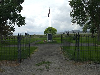
Fort Churchill State Historic Park is a state park of Nevada, United States, preserving the remains of a United States Army fort and a waystation on the Pony Express and Central Overland Routes dating back to the 1860s. The site is one end of the historic Fort Churchill and Sand Springs Toll Road. The park is in Lyon County south of the town of Silver Springs, on U.S. Route 95 Alternate, eight miles (13 km) south of U.S. Route 50. Fort Churchill was designated a National Historic Landmark in 1961. A 1994 park addition forms a corridor along the Carson River.

Oak Grove Butterfield Stage Station is located in the western foothills of the Laguna Mountains, in northern San Diego County, California. It is located on State Route 79, 13 miles (21 km) northwest of Warner Springs and Warner's Ranch. The station was built on the site of Camp Wright, an 1860s Civil War outpost.

The Hollenberg Pony Express Station, also known as Cottonwood Pony Express Station, is the most intact surviving station of the Pony Express in the United States. It was built by Gerat H. Hollenberg in 1858, to serve travelers on the Oregon and California Trails, and was used by the Pony Express when it was established in 1860. The station is owned by the state of Kansas and is operated by the Kansas Historical Society as Hollenberg Pony Express Station State Historic Site. It was designated a National Historic Landmark in 1961.

Confederate Reunion Grounds is a Texas historic site located near Mexia, Limestone County, Texas at the confluence of the Navasota River and Jack's Creek. From 1889–1946, Confederate Civil War veterans and families reunited at the site during late-July or early-August, camping under the giant bur oaks, enjoying speeches, concerts, dances, fellowship and food, and raising funds for families of their fallen comrades.

This is a list of the National Register of Historic Places listings in Morrill County, Nebraska.

Schellbourne, formerly known as Fort Schellbourne and Schell Creek Station is a ghost town located in the Schell Creek Range in White Pine County in Nevada, United States, located 43 miles (69 km) north of Ely. The town was a stopover along the Central Overland Route, Pony Express and original routing of the Lincoln Highway. It is today Nevada Historical Marker number 51. The site was listed on the National Register of Historic Places in 1972. Its boundaries were increased in 1977.

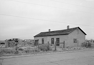
The Ruby Valley Pony Express Station, located at 1515 Idaho St. in Elko, Nevada, was built in 1860 in Ruby Valley, Nevada. It was moved in 1960 approximately 60 miles (97 km) to Elko, during the centennial anniversary year for the Pony Express, and then restored, and is listed on the National Register of Historic Places. The building is significant as one of only two surviving Pony Express buildings in Nevada, out of 43 stations in Nevada.

The Mud Springs Station Archaeological District, which includes the Mud Springs Pony Express Station Site, near Dalton, Nebraska, has significance dating to the mid-19th century. The Pony Express station at Mud Springs, staffed by U.S. soldiers, was attacked by Lakota, Cheyenne, and Arapaho tribesmen during February 4–6, 1865, in what became known as the Battle of Mud Springs.
The Cold Spring and Inscription Rock Historic District is a 2-acre (0.81 ha) historic district in Cimarron County, Oklahoma, near Boise City, Oklahoma that was listed on the U.S. National Register of Historic Places in 1994. It is associated with NPS Master Plan #122. The district includes a landscape; it includes two contributing buildings and two other contributing sites.

The Sand Springs Station is a historic site in Churchill County, Nevada that was listed on the National Register of Historic Places in 1980. A Pony Express station existed there in 1860. The ruins are located within the boundaries of the Sand Mountain Recreation Area.
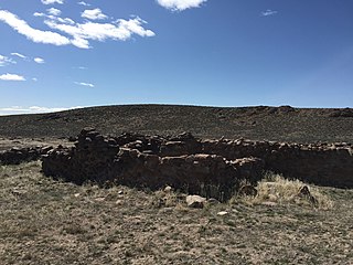
Cold Springs Pony Express Station Ruins, in Churchill County, Nevada near Frenchman, are the ruins of a Pony Express station built in 1860 or 1861. The ruins were listed as a 9.9-acre (4.0 ha) historic site on the National Register of Historic Places in 1972.

The Point of Rocks Stage Station is a former resting place at the meeting point of the Overland Trail and the Union Pacific Railroad in Sweetwater County, Wyoming, USA. It was built as a stop for the Overland Stage Line in the 1861 or 1862, equidistant between the earlier Black Buttes and Salt Wells stations, which were 28 miles (45 km) apart. The station served the stage line from 1862 to 1868. In 1868, the Union Pacific line reached Point of Rocks, putting the stage line out of business. The station then became a freight depot for nearby mines, with a road leading to Atlantic City and South Pass. The freight activity declined, and in 1877, the station became a residence. At one point it was allegedly inhabited by Jim McKee, a former member of the Hole in the Wall Gang. It became the property of the state of Wyoming in 1947 and is administered as Point of Rocks Stage Station State Historic Site.
Granger Station State Historic Site, also known as Granger Stage Station, South Bend Station and Ham's Fork Station, is a Wyoming state park dedicated to the interpretation of the station, the Pony Express and the Overland Trail. A settlement was first established about 1856 at the meeting of Ham's Fork with Black's Fork of the Green River, where a ferry crossed Ham's Fork. This became a station on the Pony Express in 1860-1861, then was a station on the Overland Trail in 1862. By this time it was known as the South Bend Station. In 1868 the trail was superseded when the Union Pacific Railroad arrived at the site. The station was deeded to the State of Wyoming in 1930. It is operated as a state historic site. The Granger Station was placed on the National Register of Historic Places on February 26, 1970.

The Diamond Springs Stage Station Site, in Keith County, Nebraska near Brule, Nebraska was the site of a stagecoach station in 1859. It was listed on the National Register of Historic Places in 1970.


