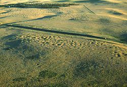
Fort Union Trading Post National Historic Site is a partial reconstruction of the most important fur trading post on the upper Missouri, 1829-1867. The fort site is about two miles from the confluence of the Missouri River and its tributary, the Yellowstone River, on the North Dakota/Montana border, 25 miles from Williston, North Dakota.

There are 460 properties and historic districts listed on the National Register of Historic Places in North Dakota. There are listings in 52 of North Dakota's 53 counties.

SunWatch Indian Village / Archaeological Park, previously known as the Incinerator Site, and designated by the Smithsonian trinomial 33-MY-57, is a reconstructed Fort Ancient Native American village next to the Great Miami River on West River Road in Dayton, Ohio. The dwellings and site plan of the 3-acre (1.2 ha) site are based on lengthy archeological excavations sponsored by the Dayton Society of Natural History, which owns and operates the site as an open-air museum. Because of its archaeological value, the site was listed in 1974 on the National Register of Historic Places. Since that time, as the many years of archaeological research at the site have led to important findings about the Fort Ancient culture, SunWatch Indian Village was designated in 1990 as a National Historic Landmark.

The Kincaid Mounds Historic Site c. 1050–1400 CE, is a Mississippian culture archaeological site located at the southern tip of present-day U.S. state of Illinois, along the Ohio River. Kincaid Mounds has been notable for both its significant role in native North American prehistory and for the central role the site has played in the development of modern archaeological techniques. The site had at least 11 substructure platform mounds, and 8 other monuments.

The Sunken Village Archeological Site, designated by the Smithsonian trinomial 35MU4, is an archaeological site on Sauvie Island in Multnomah County, Oregon, United States. The site consists of a remarkably well-preserved Chinookan village, dating back more than 700 years. It is a major example of a wet archaeological site, in which cultural materials were preserved in an anaerobic freshwater environment. Finds at the site include well-preserved basketry. The site was declared a National Historic Landmark in 1989.

The Brooks River Archaeological District encompasses a large complex of archaeological sites along the banks of the Brooks River in Katmai National Park and Preserve in the U.S. state of Alaska. It includes at least twenty separate settlement sites with documented occupation dates from 2500 BCE to recent (post-contact) history. It was declared a National Historic Landmark in 1993. The site is partly occupied by the Brooks Camp, one of the major visitor areas of the park.

The Gallagher Flint Station Archeological Site is an archaeological site and National Historic Landmark in northern Alaska. Discovered in 1970 during the construction of the Trans-Alaska Pipeline, it yielded a radiocarbon date of 10,540 B.P., making it the oldest site of human activity then known in the state.

Silver Mound is a sandstone hill in Wisconsin where American Indians quarried quartzite for stone tools. Tools made from Silver Mound's quartzite have been found as far away as Kentucky. The oldest have been dated to around 11,000 years ago, so they provide clues about the first people in Wisconsin. Silver Mound Archeological District was declared a National Historic Landmark in 2006.

The Iyatayet Site is an archaeological site and National Historic Landmark located on the northwest shore of Cape Denbigh on Norton Bay in Nome Census Area, Alaska. It shows evidence of several separate cultures, dating back as far as 6000 B.C. It was excavated starting in 1948 by J. Louis Giddings, the pioneering archaeologist of the area. It is significant as the type site of the Norton culture, representative of human occupation c. 500BCE-500CE, first described by Giddings in 1964. It is also significant for the Cape Denbigh Flint Complex, which lay underneath the Norton materials, and provides evidence of some of the earliest human activity in the region. The site was declared a National Historic Landmark in 1961.
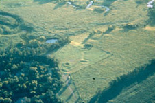
The Menoken Indian Village Site, also known as Menoken Site, Verendrye Site or Apple Creek Site is an archeological site near Bismarck, North Dakota. The site, that of a fortified village occupied c. 1300, is important in the region's prehistory, as it is one of the only sites that predates sites that are more clearly associated with the historic Hidatsa, Mandan, and Arikara cultures. It was declared a National Historic Landmark in 1964. It is located on 171st Street NE, north of Menoken, about 10 miles (16 km) east of Bismarck. The site managed by the state as the Menoken Indian Village State Historic Site, and is open to the public.
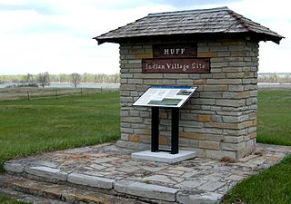
The Huff Archeological Site is a prehistoric Mandan village in North Dakota dated around 1450 AD. It was discovered in the early 1900s. The site has been designated a National Historic Landmark, and is one of the best preserved sites of the period.

The Whiteford (Price) Archeological Site, designated by the Smithsonian trinomial 14SA1, is an archaeological site located in a rural area between Salina and New Cambria, Kansas, United States. A National Historic Landmark, the site is significant as an important Central Plains habitation site, with an unusually well-preserved burial complex. The site is on private land, and is not open to the public.

The Arzberger Site, designated by archaeologists with the Smithsonian trinomial 39HU6, is a major archaeological site in Hughes County, near Pierre, South Dakota. It was declared a National Historic Landmark in 1964. It is a large fortified village, that is the type site for the Initial Coalescent, a culture that flourished in the area c. 1200-1350 CE.
The Vanderbilt Archeological Site is an archaeological site located on the shore of Lake Oahe in Campbell County, South Dakota, near Pollock, South Dakota. The site contains the remains of a Native American Plains village which has been tentatively dated to about 1300 AD. Despite the fact that the site is subject to erosive destruction from wave action on the lake, it has been determined likely to yield significant information about the movements and living patterns of prehistoric Native Americans in the region. The site was declared a National Historic Landmark in 1997.
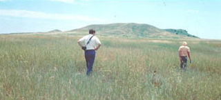
The Langdeau Site, designated by the Smithsonian trinomial 39LM209, is an archaeological site in Lyman County, South Dakota, near Lower Brule. It was declared a National Historic Landmark in 1964. The site was one of the first to provide evidence of horticultural activity by Native Americans in the region.

Barton Village Site, also known as the Herman Barton Indian Village Archeological Site, is a large, multi-component archaeological site near Cumberland in Allegany County, Maryland.
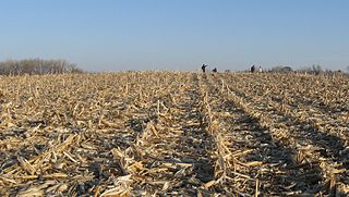
Kimball Village is an archaeological site located in the vicinity of Westfield, Iowa, United States. It is one of six known Big Sioux phase villages from the Middle Missouri Tradition that existed between 1100-1250 C.E. The site, located on a terrace overlooking the Big Sioux River, has well-preserved features, including earth lodge and storage pits, and evidence of fortifaction. The site was listed on the National Register of Historic Places in 2010, and as a National Historic Landmark in 2016.
