
The Mississippian culture was a Native American civilization that flourished in what is now the Midwestern, Eastern, and Southeastern United States from approximately 800 CE to 1600 CE, varying regionally. It was known for building large, earthen platform mounds, and often other shaped mounds as well. It was composed of a series of urban settlements and satellite villages (suburbs) linked together by loose trading networks. The largest city was Cahokia, believed to be a major religious center located in what is present-day southern Illinois.

Wickliffe Mounds is a prehistoric, Mississippian culture archaeological site located in Ballard County, Kentucky, just outside the town of Wickliffe, about 3 miles (4.8 km) from the confluence of the Ohio and Mississippi rivers. Archaeological investigations have linked the site with others along the Ohio River in Illinois and Kentucky as part of the Angel Phase of Mississippian culture. Wickliffe Mounds is controlled by the State Parks Service, which operates a museum at the site for interpretation of the ancient community. Listed on the National Register of Historic Places, it is also a Kentucky Archeological Landmark and State Historic Site.
The Taensa were a Native American people whose settlements at the time of European contact in the late 17th century were located in present-day Tensas Parish, Louisiana. The meaning of the name, which has the further spelling variants of Taenso, Tinsas, Tenza or Tinza, Tahensa or Takensa, and Tenisaw, is unknown. It is believed to be an autonym. The Taensa should not be confused with the Avoyel, known by the French as the petits Taensas, who were mentioned in writings by explorer Pierre Le Moyne d'Iberville in 1699. The Taensa are more closely related to the Natchez people and both are considered descendants of the late prehistoric Plaquemine culture.

The Nodena Site is an archeological site east of Wilson, Arkansas and northeast of Reverie, Tennessee in Mississippi County, Arkansas, United States. Around 1400–1650 CE an aboriginal palisaded village existed in the Nodena area on a meander bend of the Mississippi River. The Nodena site was discovered and first documented by Dr. James K. Hampson, archaeologist and owner of the plantation on which the Nodena site is located. Artifacts from this site are on display in the Hampson Museum State Park in Wilson, Arkansas. The Nodena Site is the type site for the Nodena Phase, believed by many archaeologists to be the province of Pacaha visited by Spanish explorer Hernando de Soto in 1542.

The Emerald Mound Site, also known as the Selsertown site, is a Plaquemine culture Mississippian period archaeological site located on the Natchez Trace Parkway near Stanton, Mississippi, United States. The site dates from the period between 1200 and 1730 CE. It is the type site for the Emerald Phase of the Natchez Bluffs Plaquemine culture chronology and was still in use by the later historic Natchez people for their main ceremonial center. The platform mound is the second-largest Mississippian period earthwork in the country, after Monk's Mound at Cahokia, Illinois.
Grand Village of the Natchez, also known as the Fatherland Site, is a 128.1-acre (0.518 km2) site encompassing a prehistoric indigenous village and earthwork mounds in present-day south Natchez, Mississippi. The village complex was constructed starting about 1200 CE by members of the prehistoric Plaquemine culture. They built the three platform mounds in stages. Another phase of significant construction work by these prehistoric people has been dated to the mid-15th century. It was named for the historic Natchez people, who used the site in the 17th and 18th centuries.

The Holly Bluff Site, sometimes known as the Lake George Site, and locally as "The Mound Place," is an archaeological site that is a type site for the Lake George phase of the prehistoric Plaquemine culture period of the area. The site is on the southern margin of the Mississippian cultural advance down the Mississippi River and on the northern edge of that of the Cole's Creek and Plaquemine cultures of the South." The site was first excavated by Clarence Bloomfield Moore in 1908 and tested by Philip Phillips, Paul Gebhard and Nick Zeigler in 1949.

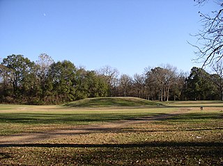
Winterville is an unincorporated community located in Washington County, Mississippi, near Mississippi Highway 1. Winterville is approximately 3 miles (4.8 km) north of Greenville, the county seat, and approximately 4 miles (6.4 km) south of Lamont.

Kings Crossing Site is an archaeological site that is a type site for the Kings Crossing Phase of the Lower Yazoo Basin Coles Creek chronology.

Coles Creek culture is a Late Woodland archaeological culture in the Lower Mississippi valley in the Southeastern Woodlands. It followed the Troyville culture. The period marks a significant change in the cultural history of the area. Population increased dramatically and there is strong evidence of a growing cultural and political complexity, especially by the end of the Coles Creek sequence. Although many of the classic traits of chiefdom societies are not yet manifested, by 1000 CE the formation of simple elite polities had begun. Coles Creek sites are found in Arkansas, Louisiana, and Mississippi. It is considered ancestral to the Plaquemine culture.
The Plaquemine culture was an archaeological culture centered on the Lower Mississippi River valley. It had a deep history in the area stretching back through the earlier Coles Creek and Troyville cultures to the Marksville culture. The Natchez and related Taensa peoples were their historic period descendants. The type site for the culture is the Medora Site in Louisiana; while other examples include the Anna, Emerald, Holly Bluff, and Winterville sites in Mississippi.

The Aden Site is an archaeological site that is the type site for the Aden Phase of Lower Yazoo Basin Coles Creek culture chronology. It corresponds to Middle Coles Creek, chronologically between the Bayland Phase and Kings Crossing Phase.

The Medora Site (16WBR1) is an archaeological site that is a type site for the prehistoric Plaquemine culture period. The name for the culture is taken from the proximity of Medora to the town of Plaquemine, Louisiana. The site is in West Baton Rouge Parish, Louisiana, and was inhabited from approximately 1300 to 1600 CE. It consisted of two mounds separated by a plaza. In the winter of 1939-40 excavation of this site was undertaken by the Louisiana State Archaeological Survey, a joint project of Louisiana State University and the Work Projects Administration. It was directed by James A. Ford, and George I. Quimby. The excavations of the site were instrumental in defining the characteristics of the Plaquemine period and culture.

Mississippian culture pottery is the ceramic tradition of the Mississippian culture found as artifacts in archaeological sites in the American Midwest and Southeast. It is often characterized by the adoption and use of riverine shell-tempering agents in the clay paste. Shell tempering is one of the hallmarks of Mississippian cultural practices. Analysis of local differences in materials, techniques, forms, and designs is a primary means for archaeologists to learn about the lifeways, religious practices, trade, and interaction among Mississippian peoples. The value of this pottery on the illegal antiquities market has led to extensive looting of sites.

Pocahontas Mounds is an archaeological site from the Plaquemine Mississippian culture in Hinds County, Mississippi, dating from 800 to 1300 CE. Two mounds from the site were added to the NRHP on two separate occasions, Pocahontas Mound A on November 25, 1969 as NRIS number 69000365 and Pocahontas Mound B on April 11, 1972 as NRIS number 72000694.

The Sims Site (16SC2), also known as Sims Place, is an archaeological site located in Saint Charles Parish, Louisiana, near the town of Paradis. The location is a multi-component mound and village complex with platform mounds and extensive midden deposits. The site habitations are divided into three periods. It was first inhabited about 800 CE by peoples of the Coastal Coles Creek culture. By 1100 CE the culture of the site had transitioned into the Mississippianized Plaquemine culture that lasted until 1450 CE. A little later was a Late Mississippian/protohistoric period that lasted from 1500 until about 1700 or 1800.
The Carson Mounds,, also known as the Carson Site and Carson-Montgomery- is a large Mississippian culture archaeological site located near Clarksdale in Coahoma County, Mississippi in the Yazoo Basin. Only a few large earthen mounds are still present at Carson to this day. Archaeologists have suggested that Carson is one of the more important archaeological sites in the state of Mississippi.
The Glass Site is a Plaquemine culture archaeological site located approximately 9.5 kilometres (5.9 mi) south of Vicksburg in Warren County, Mississippi. Originally the site had four platform mounds surrounding a large open plaza, but land leveling for modern farming techniques and looting by pothunters mean only portions of three have survived into the 21st century. It was a major ceremonial center that was contemporaneous with other large Plaquemine sites including Emerald, Holly Bluff, and Winterville and whose main occupation period occurred during the protohistoric period from 1500 to 1650 CE. Parts of the site were excavated by Clarence Bloomfield Moore in 1910 and 1911, and by Lauren Elizabeth Downs in 2007-2009.
Quigualtam or Quilgualtanqui was a powerful Native American Plaquemine culture polity encountered in 1542-1543 by the Hernando de Soto expedition. The capital of the polity and its chieftain also bore the same name; although neither the chief nor his settlements were ever visited in person by the expedition. Their encounters consisted of messages sent by runners and a three-day long canoe battle on the Mississippi River. Multiple archaeological cultures, archaeological sites, and protohistoric and early historic period Native American groups have been proposed by historians and archaeologists to identify the polity, but their identity will probably never be known with any degree of certainty.


