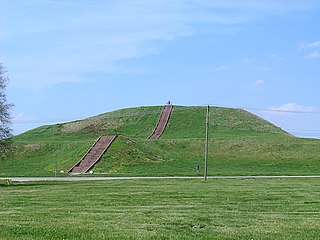
The Cahokia Mounds State Historic Site is the site of a pre-Columbian Native American city directly across the Mississippi River from present-day St. Louis, Missouri. This historic park lies in south-western Illinois between East St. Louis and Collinsville. The park covers 2,200 acres (890 ha), or about 3.5 square miles (9 km2), and contains about 80 manmade mounds, but the ancient city was much larger. At its apex around 1100 CE, the city covered about 6 square miles (16 km2) and included about 120 earthworks in a wide range of sizes, shapes, and functions.

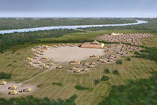
The Mississippian culture was a Native American civilization that flourished in what is now the Midwestern, Eastern, and Southeastern United States from approximately 800 CE to 1600 CE, varying regionally. It was known for building large, earthen platform mounds, and often other shaped mounds as well. It was composed of a series of urban settlements and satellite villages linked together by loose trading networks. The largest city was Cahokia, believed to be a major religious center located in what is present-day southern Illinois.

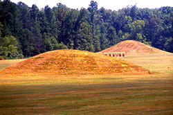
Shiloh Indian Mounds Site (40HR7) is an archaeological site of the South Appalachian Mississippian culture. It is located beside the Tennessee River on the grounds of the Shiloh National Military Park, in Hardin County of southwestern Tennessee. A National Historic Landmark, it is one of the largest Woodland era sites in the southeastern United States.

This is a list of properties and districts in Illinois that are on the National Register of Historic Places. There are over 1,900 in total. Of these, 85 are National Historic Landmarks. There are listings in all of the state's 102 counties.
This National Park Service list is complete through NPS recent listings posted July 28, 2023.
Spiro Mounds is an archaeological site located in present-day eastern Oklahoma that remains from an indigenous Indian culture that was part of the major northern Caddoan Mississippian culture. The 80-acre site is located within a floodplain on the southern side of the Arkansas River. The modern town of Spiro developed approximately seven miles to the south.

The Kolomoki Mounds is one of the largest and earliest Woodland period earthwork mound complexes in the Southeastern United States and is the largest in Georgia. Constructed from 350CE to 600CE, the mound complex is located in southwest Georgia, in present-day Early County near the Chattahoochee River.

Town Creek Indian Mound is a prehistoric Native American archaeological site located near present-day Mount Gilead, Montgomery County, North Carolina, in the United States. The site, whose main features are a platform mound with a surrounding village and wooden defensive palisade, was built by the Pee Dee, a South Appalachian Mississippian culture people that developed in the region as early as 980 CE. They thrived in the Pee Dee River region of North and South Carolina during the Pre-Columbian era. The Town Creek site was an important ceremonial site occupied from about 1150—1400 CE. It was abandoned for unknown reasons. It is the only ceremonial mound and village center of the Pee Dee located within North Carolina.

The Kincaid Mounds Historic Site c. 1050–1400 CE, is a Mississippian culture archaeological site located at the southern tip of present-day U.S. state of Illinois, along the Ohio River. Kincaid Mounds has been notable for both its significant role in native North American prehistory and for the central role the site has played in the development of modern archaeological techniques. The site had at least 11 substructure platform mounds, and 8 other monuments.

The Emerald Mound site, also known as the Selsertown site, is a Plaquemine culture Mississippian period archaeological site located on the Natchez Trace Parkway near Stanton, Mississippi, United States. The site dates from the period between 1200 and 1730 CE. It is the type site for the Emerald Phase of the Natchez Bluffs Plaquemine culture chronology and was still in use by the later historic Natchez people for their main ceremonial center. The platform mound is the second-largest Mississippian period earthwork in the country, after Monk's Mound at Cahokia, Illinois.

The Winterville site is a major archaeological site in unincorporated Washington County, Mississippi, north of Greenville and along the river. It consists of major earthwork monuments, including more than twelve large platform mounds and cleared and filled plazas. It is the type site for the Winterville Phase of the Lower Yazoo Basin region of the Plaquemine Mississippian culture. Protected as a state park, it has been designated as a National Historic Landmark.
The Kuhn Station Site is the site of an archaeological dig on Silver Creek, near Edwardsville, Illinois. The site is roughly .3 hectares in area, and was home to a small village. The site is believed to be from the Mississippian period, but archaeologists also found artifacts dating from the Moorehead/Sand Prairie period, such as ceramics. As well, the village had an earthen embankment surrounding its perimeter, and a low platform mound.
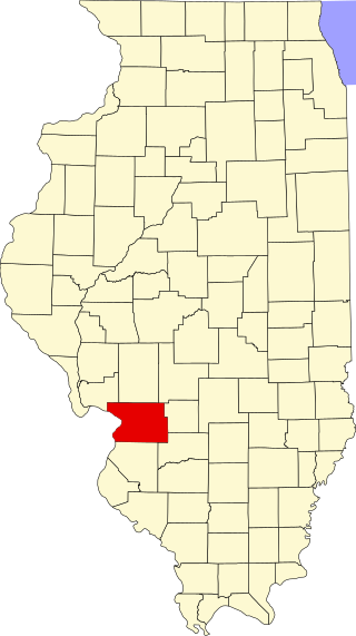
This is a list of the National Register of Historic Places listings in Madison County, Illinois.
Pharr Mounds is a Middle Woodland period archaeological site located near Tupelo in parts of Itawamba and Prentiss counties in northern Mississippi. This complex was made of earthwork mounds.
The Orr-Herl Mound and Village Site is an archaeological site located along the Ohio River in Hardin County, Illinois, United States. The site consists of a mound, which includes a sizable midden, and the remains of a village. The village was inhabited from roughly 900 to 1500 AD by Mississippian peoples. The site was an important source of fluorspar, which Mississippian peoples used for carvings and beads. The village was likely a manufacturing site for fluorspar items, which were then traded to other villages; this theory is supported by fluorspar artifacts recovered from the Kincaid Site, a Mississippian chiefdom center on the Ohio River in Illinois.

The Lunsford-Pulcher Archeological Site is a prehistoric archaeological site in rural Monroe and St. Clair counties in Illinois. The site was the location of a Middle Mississippian village which was probably a satellite community of Cahokia. Several pyramidal burial mounds are included in the site. Archaeological excavations at the site have also discovered the remains of houses and garden beds, making the site one of the few Mississippian villages at which garden beds have been found. The site has been known to European settlers since early settlement of the area in the late 18th century; despite being used for farmland, the site remains in good condition.

The Emerald Mound and Village Site is a pre-Columbian archaeological site located northwest of the junction of Emerald Mound Grange and Midgley Neiss Roads in St. Clair County, Illinois. The site includes five mounds, two of which have been destroyed by modern activity, and the remains of a village. Middle Mississippian peoples inhabited the village, which was a satellite village of Cahokia. The largest of the mounds is a two-tiered structure that stands 50 feet (15 m) high; its square base is 300 feet (91 m) across, while its upper tier is 150 feet (46 m) across. At the time of its discovery, the mound was the second-largest known in Illinois after Monks Mound at Cahokia.

The Mitchell Archaeological Site is a pre-Columbian archaeological site located at the western end of University Drive in Mitchell, Illinois. The site includes a platform mound and the remains of a village; while it once included several other mounds, they have been destroyed by modern activity. Mississippian peoples inhabited the site c. 1150–1200. The site is affiliated with the Cahokia settlement system and was the largest site in the system except for Cahokia itself. However, the majority of the site was destroyed by the construction of Interstate 270; known information about the site mainly comes from salvage excavations conducted before the highway was built.
The Carson Mounds,, also known as the Carson Site and Carson-Montgomery- is a large Mississippian culture archaeological site located near Clarksdale in Coahoma County, Mississippi in the Yazoo Basin. Only a few large earthen mounds are still present at Carson to this day. Archaeologists have suggested that Carson is one of the more important archaeological sites in the state of Mississippi.

The John Chapman Village Site is a prehistoric archaeological site located in the Apple River Valley south of Hanover, Illinois. The site includes a village area and a platform mound; the latter is the only known platform mound in the Apple River Valley. The village was occupied from roughly 1100 to 1250 A.D., toward the end of the Late Woodland period and the beginning of the Mississippian period; it is associated with a transitional phase between the two periods known as the Bennett Phase. Archaeologists have hypothesized that the site formed part of a trade network between Cahokia and settlements further north, such as Aztalan, as evidenced by the artifacts found at the site.


