Slack Farm

Last updated
Slack Farm
(15 UN 28)
Caborn Welborn Map HRoe 2010 01.jpg
Caborn-Welborn culture and some of its larger sites. Slack Farm is on the southern bank of the river.
USA Kentucky location map.svg
Archaeological site icon (red).svg
Location within Kentucky today
Location Uniontown, Kentucky,  Union County, Kentucky, Flag of the United States.svg  US
Region Union County, Kentucky
Coordinates 37°46′11.03″N88°0′28.12″W / 37.7697306°N 88.0078111°W / 37.7697306; -88.0078111
History
Founded1400 CE
Cultures Caborn-Welborn variant of the Mississippian culture
Site notes
Architecture
Architectural styles Platform mound
Responsible body: private

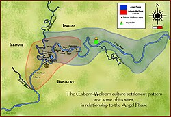
Slack Farm (15 UN 28) is an archaeological site of the Caborn-Welborn variant of the Mississippian culture. Slack Farm is located near Uniontown, Kentucky, close to the confluence of the Ohio River and the Wabash Rivers. The site included a Native American mound and an extensive village occupation dating between 1400–1650 CE. Although Slack Farm was long known to be one of the major villages of the Caborn-Welborn people, it became famous when it was very seriously damaged by looters in 1987.

Contents

Description

The Slack Farm site is located on a projecting terrace and adjacent levee 300 metres (980 ft) from the Ohio River. There was a mound (Site 15 UN 70) located on the bluff overlooking the site. The Slack Farm site itself consisted of seven discrete village areas surrounding a central plaza and covering roughly 14 ha. A shallow ravine bisects the site running from the west to the south. Houses were typical Mississippian rectangular wall trench wattle and daub structures set in shallow basins. Many had prepared clay hearths. Located near most houses were special pits used to store maize and other dried foods. The pits were large enough to have stored enough grain to feed 7 to 12 people for a year. [1]

Graves

Each section of the large village maintained its own cemetery. Burials were typically in extended positions. They were often laid out in parallel rows and the absence of overlapping burials suggests that they were marked in some way. Grave goods such as limestone disc pipes, shell beads and ear plugs, as well as small pottery jars were often included, usually near the body's upper torso. In Late Caborn-Welborn times, European trade goods such as glass beads, copper/brass bracelets and tubes were deposited in the graves. During the 1987 looting, 650 to 750 graves were opened by the looters. Given the fact that infants and children are under-represented in this total, archaeologists speculate that as many as a thousand or more people could have been buried at the seven cemeteries at the site. [1]

1987 looting and its effects

In 1987 the ten looters of Slack Farm paid $10,000 to a new landowner of the Slack Farm property for the right to dig at the site. After renting a tractor, the ten individuals spent two months destroying hundreds of Native American graves, Mississippian culture houses, and unknown other artifacts. Local complaints by the people of Uniontown led to the arrest of the perpetrators for the misdemeanor of "desecrating a venerable object" (a charge which is now a felony, in part due to the controversy over Slack Farm). Prosecution on this charge was difficult in the late 1980s, in part because this predated the passage of the Native American Graves Protection and Repatriation Act and related state legislation, which made it clearer that such activities were illegal.

The looting of Slack Farm contributed to the passage of more stringent laws in the state of Kentucky relating to the protection of burials, sacred grounds, and indigenous/archaeological sites. The damage done to Slack Farm attracted worldwide attention and was written about in National Geographic magazine, [2] prompting widespread outcry against illicit removal of antiquities.

The hundreds of broken bones were reburied by Native American groups. As of May 2007, Native American groups still meet in the area to commemorate the site and mourn the damage done.

See also

Related Research Articles

<span class="mw-page-title-main">Fort Ancient</span> Archaeological culture in the Ohio River valley

Fort Ancient is a name for a Native American culture that flourished from c. 1000–1750 CE and predominantly inhabited land near the Ohio River valley in the areas of modern-day southern Ohio, northern Kentucky, southeastern Indiana and western West Virginia. Although a contemporary of the Mississippian culture, they are often considered a "sister culture" and distinguished from the Mississippian culture. While far from agreed upon, there is evidence to suggest that the Fort Ancient Culture were not the direct descendants of the Hopewellian Culture. It is suspected that the Fort Ancient Culture introduced maize agriculture to Ohio. The Fort Ancient Culture were most likely the builders of the Great Serpent Mound. Recent archeological study and carbon dating suggests that Alligator Mound in Granville also dates to the Fort Ancient era, rather than the assumed Hopewell era. It is believed that neither the Serpent or Alligator Mounds are burial locations, but rather served as ceremonial effigy sites.

<span class="mw-page-title-main">Angel Mounds</span> United States historic place

Angel Mounds State Historic Site, an expression of the Mississippian culture, is an archaeological site managed by the Indiana State Museum and Historic Sites that includes more than 600 acres of land about 8 miles (13 km) southeast of present-day Evansville, in Vanderburgh and Warrick counties in Indiana. The large residential and agricultural community was constructed and inhabited from AD 1100 to AD 1450, and served as the political, cultural, and economic center of the Angel chiefdom. It extended within 120 miles (190 km) of the Ohio River valley to the Green River in present-day Kentucky. The town had as many as 1,000 inhabitants inside the walls at its peak, and included a complex of thirteen earthen mounds, hundreds of home sites, a palisade (stockade), and other structures.

<span class="mw-page-title-main">Mississippian culture</span> Mound-building Native American culture in the United States

The Mississippian culture was a Native American civilization that flourished in what is now the Midwestern, Eastern, and Southeastern United States from approximately 800 CE to 1600 CE, varying regionally. It was known for building large, earthen platform mounds, and often other shaped mounds as well. It was composed of a series of urban settlements and satellite villages linked together by loose trading networks. The largest city was Cahokia, believed to be a major religious center located in what is present-day southern Illinois.

<span class="mw-page-title-main">Lake Jackson Mounds Archaeological State Park</span> Park in Tallahassee, Florida

Lake Jackson Mounds Archaeological State Park (8LE1) is one of the most important archaeological sites in Florida, the capital of chiefdom and ceremonial center of the Fort Walton Culture inhabited from 1050–1500. The complex originally included seven earthwork mounds, a public plaza and numerous individual village residences.

<span class="mw-page-title-main">Caborn-Welborn culture</span> Early North American Indigenous culture

Caborn-Welborn was a precontact and proto-historic North American culture defined by archaeologists as a Late Mississippian cultural manifestation that grew out of – or built upon the demise of – the Angel chiefdom located in present-day southern Indiana. Caborn-Welborn developed around 1400 and seems to have disappeared around 1700 CE. The Caborn-Welborn culture was the last Native American occupation of southern Indiana prior to European contact. It remains unclear which post-contact Native group, if any, are their descendants.

The Angel phase describes a 300–400-year cultural manifestation of the Mississippian culture of the central portions of the United States of America, as defined in the discipline of archaeology. Angel phase archaeological sites date from c. 1050 - 1350 CE and are located on the northern and southern sides of the Ohio River in southern Indiana, such as National Historic Landmark Angel Mounds near present-day Evansville; northwestern Kentucky, with Wickliffe Mounds and the Tolu Site; and Kincaid Mounds State Historic Site in Illinois. Additional sites range from the mouth of Anderson River in Perry County, Indiana, west to the mouth of the Wabash in Posey County, Indiana.

<span class="mw-page-title-main">Parkin Archeological State Park</span> Archaeological site

Parkin Archeological State Park, also known as Parkin Indian Mound, is an archeological site and state park in Parkin, Cross County, Arkansas. Around 1350–1650 CE an aboriginal palisaded village existed at the site, at the confluence of the St. Francis and Tyronza rivers. Artifacts from this site are on display at the site museum. The Parkin site is the type site for the Parkin phase, an expression of the Mississippian culture from the Late Mississippian period. Many archeologists believe it to be part of the province of Casqui, documented as visited by Spanish explorer Hernando de Soto in 1542. Archeological artifacts from the village of the Parkin people are dated to 1400–1650 CE.

The Pisgah phase is an archaeological phase of the South Appalachian Mississippian culture in Southeast North America. It is associated with the Appalachian Summit area of southeastern Tennessee, Western North Carolina, and northwestern South Carolina in what is now the United States.

<span class="mw-page-title-main">Upper Mississippian culture</span> Archaeological culture in North America

The Upper Mississippian cultures were located in the Upper Mississippi basin and Great Lakes region of the American Midwest. They were in existence from approximately A.D. 1000 until the Protohistoric and early Historic periods.

<span class="mw-page-title-main">Hovey Lake-Klein Archeological Site</span> Archaeological site in Indiana, U.S.

Hovey Lake-Klein Archeological Site is an archaeological site of the Caborn-Welborn variant of the Mississippian culture. Hovey Lake-Klein Archeological Site is located on the west bank of Hovey Lake, a backwater lake near the Ohio River close to its confluence with the Wabash River. The site was an extensive village occupation dating between 1400 and 1650 CE.

<span class="mw-page-title-main">Ashworth Archaeological Site</span> Archaeological site in Indiana, US

The Ashworth Archaeological Site is a significant archaeological site in the extreme southwestern corner of the U.S. state of Indiana. Located near the confluence of the Ohio and Wabash Rivers, it lies near several similar archaeological sites. It was first examined by archaeologists in the middle of the twentieth century and found to be the site of a relatively recent Native American village, and it has been designated a historic site because of its archaeological value.

<span class="mw-page-title-main">Welborn Village Archeological Site</span>

Welborn Village Archeological Site, also known as the Murphy's Landings site, is an archaeological site of the prehistoric Caborn-Welborn culture variant of the Mississippian culture of indigenous peoples of North America.

<span class="mw-page-title-main">Gahagan Mounds Site</span>

The Gahagan Mounds Site (16RR1) is an Early Caddoan Mississippian culture archaeological site in Red River Parish, Louisiana. It is located in the Red River Valley. The site is famous for the three shaft burials and exotic grave goods excavated there in the early twentieth century.

<span class="mw-page-title-main">Old Town (Franklin, Tennessee)</span>

Old Town is an archaeological site in Williamson County, Tennessee near Franklin. The site includes the remnants of a Native American village and mound complex of the Mississippian culture, and is listed on the National Register of Historic Places (NRHP) as Old Town Archaeological Site (40WM2).

<span class="mw-page-title-main">Nodena phase</span>

The Nodena phase is an archaeological phase in eastern Arkansas and southeastern Missouri of the Late Mississippian culture which dates from about 1400–1650 CE. The Nodena phase is known from a collection of villages along the Mississippi River between the Missouri Bootheel and Wapanocca Lake. They practiced extensive maize agriculture and artificial cranial deformation and were members of a continent wide trade and religious network known as the Southeastern Ceremonial Complex, which brought chert, whelk shells, and other exotic goods to the area.

Stone box graves were a method of burial used by Native Americans of the Mississippian culture in the Midwestern United States and the Southeastern United States. Their construction was especially common in the Cumberland River Basin, in settlements found around present-day Nashville, Tennessee.

<span class="mw-page-title-main">Fewkes Group Archaeological Site</span> Archaeological site in Tennessee

Fewkes Group Archaeological Site, also known as the Boiling Springs Site, is a pre American history Native American archaeological site located in the city of Brentwood, in Williamson County, Tennessee. It is in Primm Historic Park on the grounds of Boiling Spring Academy, a historic schoolhouse established in 1830. The 15-acre site consists of the remains of a late Mississippian culture mound complex and village roughly dating to 1050-1475 AD. The site, which sits on the western bank of the Little Harpeth River, has five mounds, some used for burial and others, including the largest, were ceremonial platform mounds. The village was abandoned for unknown reasons around 1450. The site is named in honor of Dr. J. Walter Fewkes, the Chief of the Bureau of American Ethnology in 1920, who had visited the site and recognized its potential. While it was partially excavated by the landowner in 1895, archaeologist William E. Myer directed a second, more thorough excavation in October 1920. The report of his findings was published in the Bureau of American Ethnology's Forty-First Annual Report. Many of the artifacts recovered from the site are now housed at the Smithsonian Institution. It was added to the National Register of Historic Places on April 21, 1980, as NRIS number 80003880.

<span class="mw-page-title-main">Mound 72</span> Small ridgetop Mississippian mound near Collinsville, Illinois

Mound 72 is a small ridgetop mound located roughly 850 meters (2,790 ft) to the south of Monks Mound at Cahokia Mounds near Collinsville, Illinois. Early in the site's history, the location began as a circle of 48 large wooden posts known as a "woodhenge". The woodhenge was later dismantled and a series of mortuary houses, platform mounds, mass burials and eventually the ridgetop mound erected in its place. The mound was the location of the "beaded burial", an elaborate burial of an elite personage thought to have been one of the rulers of Cahokia, accompanied by the graves of several hundred retainers and sacrificial victims.

The Gentleman Farm site is located in LaSalle County, Illinois, on the Illinois River. It is a multi-component site with the main occupation being a Langford tradition component of Upper Mississippian affiliation.

The Fisher Mound Group is a group of burial mounds with an associated village site located on the DesPlaines River near its convergence with the Kankakee River where they combine to form the Illinois River, in Will County, Illinois, about 60 miles southwest of Chicago. It is a multi-component stratified site representing several Prehistoric Upper Mississippian occupations as well as minor Late Woodland and Early Historic components.

References

  1. 1 2 Pollack, David (2004). Caborn-Welborn – Constructing a New Society after the Angel Chiefdom Collapse. University of Alabama Press. pp. 101–106. ISBN   0-8173-5126-4.
  2. National Geographic Magazine, March 1989