Effigy Mounds National Monument preserves more than 200 prehistoric mounds built by Native Americans. Numerous effigy mounds are shaped like animals, including bears and birds. These were built mostly in the first millennium, by peoples of the Woodland Culture. In 2017, they were featured in the America the Beautiful Quarters Program.

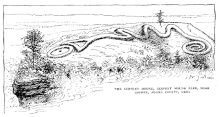
The Great Serpent Mound is a 1,348-foot (411 m)-long, three-foot-high prehistoric effigy mound on a plateau of the Serpent Mound crater along Ohio Brush Creek in Adams County, Ohio. Maintained within a park by Ohio History Connection, it has been designated a National Historic Landmark by the United States Department of Interior. The Serpent Mound of Ohio was first reported from surveys by Ephraim Squire and Edwin Davis in their historic volume Ancient Monuments of the Mississippi Valley, published in 1848 by the newly founded Smithsonian Museum.

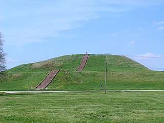
Fort Ancient is a name for a Native American culture that flourished from Ca. 1000-1750 CE and predominantly inhabited land near the Ohio River valley in the areas of modern-day southern Ohio, northern Kentucky, southeastern Indiana and western West Virginia. Although a contemporary of the Mississippian Culture, they are often considered a "sister culture" and distinguished from the Mississippian Culture. Although far from agreed upon, there is evidence to suggest that the Fort Ancient Culture were not the direct descendants of the Hopewellian Culture]. It is suspected that the Fort Ancient Culture introduced maize agriculture to Ohio. The Fort Ancient Culture were most likely the builders of the Great Serpent Mound.

A mound is a heaped pile of earth, gravel, sand, rocks, or debris. Most commonly, mounds are earthen formations such as hills and mountains, particularly if they appear artificial. A mound may be any rounded area of topographically higher elevation on any surface. Artificial mounds have been created for a variety of reasons throughout history, including ceremonial, burial (tumulus), and commemorative purposes.

An effigy mound is a raised pile of earth built in the shape of a stylized animal, symbol, human, or other figure and generally containing one or more human burials. Effigy mounds were primarily built during the Late Woodland Period. Conical and linear mounds, the predecessors of effigy mounds may date from as far back as 700 BCE. They remain places First Peoples frequent to visit and speak with ancestors, to put down tobacco and to give thanks. These sites are primarily visited by Hochungra people whose ancestors likely built the great majority of them, though they are also visited by people from other original indigenous nations such as Anishinaabe (Ojibwe), Kikapu, Oneida, Menominii who reside in Wisconsin and surrounding areas. There also remains the possibility that a greater diversity of First Peoples such as ancestors of those named nations may have contributed to building some percentage of the mounds. That is to say that ancestral Hochunk likely popularized the form and other groups may have adopted the practice of building effigy mounds from having observed the Hochunk ancestors methods and aesthetics surrounding their construction.
Cold Water Spring State Preserve is a 60-acre (240,000 m2) parcel state preserve protecting a spring that issues from Cold Water Cave, an extensive cave system in Winneshiek County, Iowa and Fillmore County, Minnesota. The spring is a tributary of the Upper Iowa River.

The Toolesboro Mound Group, a National Historic Landmark, is a group of Havana Hopewell culture earthworks on the north bank of the Iowa River near its discharge into the Mississippi. The mounds are owned and displayed to the public by the State Historical Society of Iowa. The mound group is located east of Wapello, Iowa, near the unincorporated community of Toolesboro.
Slinde Mounds State Preserve contains ancient Indian mound burials in some hill prairie. About 32 acres (130,000 m2) in extent, it is on a terrace above Canoe Creek, a tributary of the Upper Iowa River, and is approximately six miles from Waukon, Iowa in Hanover Township, in Allamakee County.

Fish Farm Mounds State Preserve is a 3-acre (12,000 m2) archaeological mound group containing Native American burials in the U.S. state of Iowa. It is located within the larger Fish Farms Mounds Wildlife area, a state owned hunting area a few miles south of New Albin, just inland from the Upper Mississippi River in Allamakee County.

The Beattie Park Mound Group is a grouping of Late Woodland period Indian mounds located in downtown Rockford, Illinois, United States.
The Little Maquoketa River Mounds State Preserve is an Iowa state owned archaeological site and natural area located within the city of Sageville on U.S. Highway 52.

Rock Eagle Effigy Mound is an archaeological site in Putnam County, Georgia, U.S. estimated to have been constructed c. 1000 BC to AD 1000. The earthwork was built up of thousands of pieces of quartzite laid in the mounded shape of a large bird. Although it is most often referred to as an eagle, scholars do not know exactly what type of bird the original builders intended to portray. It is listed on the National Register of Historic Places (NRHP) because of its significance. The University of Georgia administers the site. It uses much of the adjoining land for a 4-H camp, with cottages and other buildings, and day and residential environmental education.
Rock Hawk Effigy Mound is an archaeological site in Putnam County, Georgia, United States. It consists of thousands of pieces of quartzite laid in the shape of a large bird. Although it is most often referred to as a hawk, scholars do not know exactly what type of bird the original builders intended to portray.
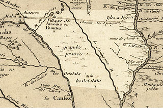
The Blood Run Site is an archaeological site on the border of the US states of Iowa and South Dakota. The site was essentially populated for 8,500 years, within which earthworks structures were built by the Oneota Culture and occupied descendant tribes such as the Ioway, Otoe, Missouri, and shared with Quapaw and later Kansa, Osage, and Omaha people. The site was so named on account of the iron-stained soil.

The archaeology of Iowa is the study of the buried remains of human culture within the U.S. state of Iowa from the earliest prehistoric through the late historic periods. When the American Indians first arrived in what is now Iowa more than 13,000 years ago, they were hunters and gatherers living in a Pleistocene glacial landscape. By the time European explorers visited Iowa, American Indians were largely settled farmers with complex economic, social, and political systems. This transformation happened gradually. During the Archaic period American Indians adapted to local environments and ecosystems, slowly becoming more sedentary as populations increased. More than 3,000 years ago, during the Late Archaic period, American Indians in Iowa began utilizing domesticated plants. The subsequent Woodland period saw an increase on the reliance on agriculture and social complexity, with increased use of mounds, ceramics, and specialized subsistence. During the Late Prehistoric period increased use of maize and social changes led to social flourishing and nucleated settlements. The arrival of European trade goods and diseases in the Protohistoric period led to dramatic population shifts and economic and social upheaval, with the arrival of new tribes and early European explorers and traders. During the Historical period European traders and American Indians in Iowa gave way to American settlers and Iowa was transformed into an agricultural state.

The following outline is provided as an overview of and topical guide to the U.S. state of Iowa.
American Indians of Iowa include numerous Native American tribes and prehistoric cultures that have lived in this territory for thousands of years. There has been movement both within the territory, by prehistoric cultures that descended into historic tribes, and by other historic tribes that migrated into the territory from eastern territories. In some cases they were pushed by development pressure and warfare.
Grand Mound is a prehistoric burial site in Koochiching County, Minnesota, United States. It is the largest surviving prehistoric structure in the upper Midwest, dating back to 200 BCE. The site was listed as a National Historic Landmark on June 23, 2011.

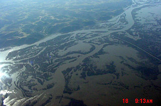
Turkey River Mounds State Preserve is a historic site located near the unincorporated community of Millville, Iowa, United States. The 62-acre (25 ha) preserve contains thirty-eight of forty-three Native American mounds located on a narrow Paleozoic Plateau at the confluence of the Mississippi and Turkey rivers. They vary in size and shape and are 1.3 feet (0.40 m) to 6 feet (1.8 m) in height. The conical mounds range from 20 feet (6.1 m) to over 100 feet (30 m) in diameter. The linear mounds vary from 80 feet (24 m) to 175 feet (53 m) in length. There is one effigy mound in the shape of a panther that is 98 feet (30 m) long and 40 feet (12 m) wide. There are also compound mounds in the preserve. The mounds were constructed during the Woodland period. They were used for burials and ceremonial places, and are now protected by law. The preserve is also home to a variety of trees, prairie grasses and flowers.