Lacey-Keosauqua State Park

Last updated
Lacey-Keosauqua State Park
Lacy Lake.jpg
Lacey-Keosauqua State Park
USA Iowa location map.svg
Red pog.svg
Location of Lacey-Keosauqua State Park in Iowa
Location Van Buren, Iowa, United States
Coordinates 40°42′37″N91°58′53″W / 40.71028°N 91.98139°W / 40.71028; -91.98139 Coordinates: 40°42′37″N91°58′53″W / 40.71028°N 91.98139°W / 40.71028; -91.98139
Area1,653 acres (6.69 km2)
Elevation732 ft (223 m) [1]
Established1921
Governing bodyIowa Department of Natural Resources
Website iowadnr.gov
Lacey-Keosauqua State Park
Lodge and Picnic Area (Area A)
Picnic and Custodial Group (Area B)
Bathing Area (Area C)
Built1933-1936
Built by Civilian Conservation Corps
Architect Central Design Office, Ames
Architectural style Rustic
MPS CCC Properties in Iowa State Parks MPS
NRHP reference No. 90001668
90001669
90001670 [2]
Added to NRHPNovember 15, 1990

Lacey-Keosauqua State Park is located southwest of Keosauqua, Iowa, United States. The park located along the Des Moines River in Van Buren County, it was dedicated in 1921. It is the largest state park in size in Iowa. In 1990 three areas were named nationally recognized historic districts and listed on the National Register of Historic Places.

Contents

History

A group of local citizens contributed $64,000 to buy the land, which had been a large farm. [3] The state acquired the land in 1920, and dedicated it as Big Bend Park the following year. In 1923 the park had 1,222.1 acres (494.6 ha), it grew to 1,526.45 acres (617.73 ha) by 1935, and 2,209.85 acres (894.29 ha) in 1942. The park currently has 1,653 acres (669 ha), making it the largest state park in Iowa. [4] It was renamed in 1926 in honor of John Fletcher Lacey, an American Civil War veteran who went on to serve in both the Iowa House of Representatives and the United States House of Representatives, representing Iowa's 6th congressional district. He was noted for conservation legislation while in Congress and was instrumental in establishing the state park system in Iowa. [4] By 1933 a lodge and a golf course, no longer extant, had been developed in the northwest part of the park.

Several government agencies worked at Lacey-Keosauqua to develop the park in the 1930s and the 1940s. The Civilian Conservation Corps (CCC) Company 770 arrived in the park on May 28, 1933. They worked with the National Forest Service landscaping and with soil erosion control along the steep river bluffs until October 11 of the same year, when it was transferred to the National Park Service. They continued their work in the park until October 23, 1934. Company 770's primary responsibility was the construction of the earthen dam and concrete spillway to create the man-made lake. CCC Company 2719 began work on August 20, 1934, and stayed until October 1935. Most of the trails were completed in 1934. The National Forest Service and both companies of the CCC built the various buildings. The Works Progress Administration (WPA) worked in the park building the foot and vehicle bridges and other small projects from December 1935 to April 1936. A National Park Service Camp began working in the park in June 1936 and remained until April 1937 or possibly into early 1938. [3] The state of Iowa built two of the six existing cabins between 1940 and 1942 and completed the others sometime after 1942.

On November 15, 1990 three areas of the park were listed as historic districts on the National Register of Historic Places. [2] At the time of its nomination it contained 37 contributing properties. [3] Area A contains an entryway, a lodge and picnic area, Area B includes another picnic area and custodial facilities, and Area C contains the bathhouse and other features along the lake. All of the historic structures in the park were designed in the rustic style by the Central Design Office in Ames. The park was part of a larger study of Iowa's state parks called the Civilian Conservation Corps Properties in Iowa State Parks: 1933-1942.

Lodge and Picnic Area (Area A)

Area A is located in the northwest corner of the park. Its historic buildings and structures include the gatehouse and portals, a regulatory sign, lodge, pump house, and picnic shelter. Two rubble limestone portals flank the entrance road. The south portal is nearly square and is 8.3 feet (2.5 m) tall. [3] The north portal is T-shaped and stands 9 feet (2.7 m) tall. The sign stands in front of the north portal. The rectangular, random rubble limestone gatehouse is separate from the portals and is located to the south of them. The lodge is a two-story, L-shaped building that is located on the main road just beyond the portals.

The main section of the structure is covered with weatherboard, and an addition is covered with uncoursed rubble. A wrap-around porch composed of stone walls covers the east side of the building and parts of the adjoining north and south facades. The underground pump house lies to the east of the lodge and is marked by its double-wooden doors. The picnic shelter is one-quarter of a mile to the southeast of the pump house. The shelter is composed of uncoursed ashlar limestone, and it is built into the side of a hill. Restrooms are located in the enclosed rear portion of the structure, and the north side is open.

Picnic and Custodial Group (Area B)

Area B is located in the north central part of the park. Its historic buildings and structures include the custodian's residence, a picnic shelter, a water fountain, two latrines, and several retaining walls at the entrance of the picnic shelter. Located in a clearing off the park road, the custodian's residence is a single-story, rectangular structure composed of rough-faced, coursed ashlar limestone. The gable ends are closed with weatherboard. It is built over a limestone basement.

The picnic area is located to the northeast of the custodian's residence. Coursed ashlar limestone encloses the rear of the shelter, and includes a fireplace. Two latrines, of coursed rubble limestone and similar in construction, flank the shelter. The water fountain is located southwest of the shelter. The entrance to the picnic area is marked by four square cement posts that are flanked by two coursed ashlar stone walls. Two 408-foot (124 m) long stone walls are located in the center of the grass parking lot. [5]

Bathing Area (Area C)

Area C is located to the south of Area B near the center of the park. It is the bathing area and it includes the lake, dam, spillway, trail surrounding the lake, the check dams and footbridge along this trail, bathhouse, beach, and pump house. Two bridges in this historic district are considered non-contributing to the historical nature of the district. The 30-acre (12 ha) lake is fed by a spring that is damned at the north end of the lake. The earthen dam with a concrete core is 450 feet (140 m) in length. [6] Rock riprapping protects its south side from erosion. A 300-foot (91 m)

Area C is located to the south of Area B near the center of the park. It is the bathing area and it includes the lake, dam, spillway, trail surrounding the lake, the check dams and footbridge along this trail, bathhouse, beach, and pump house. Two bridges in this historic district are considered non-contributing to the historical nature of the district. The ☃☃ lake is fed by a spring that is damned at the north end of the lake. The earthen dam with a concrete core is ☃☃ in length.☃☃ Rock riprapping protects its south side from erosion. A ☃☃ concrete spillway curves to the west. A 55-foot (17 m) arched, steel bridge (non-contributing) spans across the spillway. Most of the lake is surrounded by a 3.25-mile (5.23 km) trail. Ten check dams that prevent soil erosion into the lake are located along the trail. They are composed of random rubble and concrete walls.

Two coursed rubble limestone footbridges are located south of the lake. One of the two bridges is a WPA structure, and is non-contributing. The bathhouse is located near the top of a hill on the west side of the lake. The single-story uncoursed ashlar limestone building was built on concrete footings. It features a central gable with a cupola and two flanking wings. Concrete steps with random rubble side walls lead down to the beach on the lake. An uncoursed ashlar limestone pump house is built into the hillside. It has a flat roof that is also composed of limestone.

Land use

Nineteen burial mounds from the ancient Woodland Period are located in the northwest corner of the park. [4] Park visitors are granted access to them. The lake in the center of the park is used for swimming, boating, and fishing. Fishing is also permitted on the Des Moines River. The park also features trails along the lake, and along the river bluffs and valleys for hiking. There are cabins and campsites for campers. Facilities are also available for picnicking. Part of Shimek State Forest is adjacent to the park.

Related Research Articles

Maquoketa Caves State Park

Maquoketa Caves State Park is a state park of Iowa, United States, located in Jackson County. It stands northwest of the city of Maquoketa. In 1991 111 acres (45 ha) on the east side of the park were listed as a historic district on the National Register of Historic Places.

Meramec State Park

Meramec State Park is a public recreation area located near Sullivan, Missouri, about 60 miles from St. Louis, along the Meramec River. The park has diverse ecosystems such as hardwood forests and glades. There are over 40 caves located throughout the park, the geology of which is a mixture of limestone and dolomite. The most famous is Fisher Cave, located near the campgrounds. The park borders the Meramec Conservation Area.

Bald Mountain Recreation Area

Bald Mountain State Recreation Area is a 4,637-acre (1,877 ha) state park located near Lake Orion, Michigan off M-24. It consists of some of the most rugged terrain in southeastern Michigan. The recreation area is composed of a North Unit and a South Unit, which are not contiguous. The South Unit itself includes two parts separated by M-24, but the section west of M-24 has no recreational facilities or trails and is primarily undeveloped forest and grassy plains segmented by a few through-roads.

Bewabic State Park Park in Michigan, USA

Bewabic State Park is a public recreation area covering 315 acres (127 ha) on the shore of Fortune Lake, four miles (6.4 km) west of Crystal Falls in Iron County, Michigan. The state park's rich Civilian Conservation Corps history is evidenced by the CCC structures still in use. The park was listed on the National Register of Historic Places for its CCC-related architecture in 2016.

Hoeft State Park Park in Michigan, USA

P. H. Hoeft State Park is a public recreation area on the shores of Lake Huron, four miles (6.4 km) northwest of Rogers City on US 23 in Presque Isle County, Michigan. The park was added to the National Register of Historic Places in 2009.

Onaway State Park Park in Michigan, USA

Onaway State Park is a public recreation area covering 158 acres (64 ha) on the southeast shore of Black Lake in North Allis Township, Presque Isle County, Michigan. The state parks sits at the end of M-211 five miles north of Onaway. It contains sand and cobblestone beaches, large rock outcroppings, a campground, and nature trail highlighting a diversity of trees. The park was added to the National Register of Historic Places in 2009.

Wells State Park (Michigan) Park in Michigan, USA

J.W. Wells State Park is a state park in the U.S. state of Michigan. The 678-acre (2.74 km2) park is located in Menominee County on the shore of Lake Michigan's Green Bay, just south of Cedar River. It is on M-35, roughly midway between Menominee and Escanaba. It was added to the National Register of Historic Places in 2002.

Bennett Spring State Park

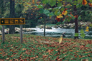
Bennett Spring State Park is a public recreation area located in Bennett Springs, Missouri, twelve miles (19 km) west of Lebanon on Highway 64 in Dallas and Laclede counties. It is centered on the spring that flows into the Niangua River and gives the park its name. The spring averages 100 million gallons of daily flow. The park offers fly fishing, camping, canoeing, hiking, and other activities.

Lake Keomah State Park

Lake Keomah State Park is a state park of Iowa, USA. It is in Mahaska County. To the park's immediate east is Keomah Village and the park is approximately 4 miles (6.4 km) east of Oskaloosa.

Table Rock State Park (South Carolina) United States historic place

Table Rock State Park is a 3,083-acre (12.48 km2) park at the edge of the Blue Ridge Mountains in northern Pickens County, South Carolina. The park includes Pinnacle Mountain, the tallest mountain totally within the state.

Backbone State Park state park in Iowa

Backbone State Park is Iowa's oldest state park, dedicated in 1919. Located in the valley of the Maquoketa River, it is approximately three miles (5 km) south of Strawberry Point in Delaware County. It is named for a narrow and steep ridge of bedrock carved by a loop of the Maquoketa River originally known as the Devil's Backbone. The initial 1,200 acres (490 ha) were donated by E.M. Carr of Lamont, Iowa. Backbone Lake Dam, a relatively low dam built by the Civilian Conservation Corps (CCC) in the 1930s, created Backbone Lake. The CCC constructed a majority of trails and buildings which make up the park.

Dolliver Memorial State Park

Dolliver Memorial State Park is a state park of Iowa, US, featuring high bluffs and deep ravines on the Des Moines River. The park is located 10 miles (16 km) south of Fort Dodge and 3 miles (4.8 km) northwest of Lehigh. The park contains two listings on the National Register of Historic Places: Dolliver Memorial State Park, Entrance Area and Dolliver Memorial State Park, Picnic, Hiking & Maintenance Area .

Black Moshannon State Park Historic Districts

The Black Moshannon State Park Historic Districts are three separate historic districts on the National Register of Historic Places (NRHP) at Black Moshannon State Park in Rush Township, Centre County, Pennsylvania in the United States. The structures in the historic districts were constructed in the 1930s during the Great Depression by the Civilian Conservation Corps (CCC). The three districts are: the Beach and Day Use District, with 18 contributing structures, including 11 different picnic pavilions, concession building, bathhouse, museum, and four open pit latrines; the Family Cabin District with 16 contributing properties, including 13 cabins, one lodge and two latrines; and the Maintenance District with four contributing properties, including a storage building, three-bay garage, gas pump house, and ranger's residence.

Gull Point State Park

Gull Point State Park is a state park of Iowa, United States, located on West Okoboji Lake in the city of Wahpeton. It is the primary state park unit in the Iowa Great Lakes region. Two areas of the park were listed as nationally recognized historic districts on the National Register of Historic Places in 1990.

Lake Ahquabi State Park

Lake Ahquabi State Park is a state park of Iowa, US, featuring a 115-acre (47 ha) reservoir. Ahquabi means "resting place" in the Fox language. The park is 6 miles (9.7 km) south of Indianola and 22 miles (35 km) south of Des Moines. Three sections of the park were listed on the National Register of Historic Places in 1991.

The Central Design Office, Ames was a design office at Iowa State, in Ames, Iowa that designed public works, many built under the Civilian Conservation Corps program. It designed many that are listed on the U.S. National Register of Historic Places.

Beeds Lake State Park

Beeds Lake State Park is located northwest of Hampton, Iowa, United States. It was listed has a historic district on the National Register of Historic Places as Beeds Lake State Park, Civilian Conservation Corps Area in 1990. At the time of its nomination it contained 21 resources, which included one contributing building, 15 contributing structures, and five non-contributing structures. The 319-acre (129 ha) park surrounds a 99-acre (40 ha) reservoir. It features hiking trails, boating, fishing, swimming, camping, picnic areas and shelters, lodges and concessions.

Pilot Knob State Park

Pilot Knob State Park is located southeast of Forest City, Iowa, United States. Founded in 1923, it is one of the oldest state parks in Iowa. Between 1990 and 1995 one area was named nationally recognized historic district and five structures were individually listed on the National Register of Historic Places.

Mitchell Powerhouse and Dam United States historic place

Mitchell Powerhouse and Dam is a historic structure located in Mitchell, Iowa, United States. The west side of town along the Cedar River developed into a processing and manufacturing area, and its mills were powered by the river's current. They all became obsolete and closed around the turn of the 20th-century. In 1917 the Northeastern Iowa Power Co. was incorporated at Clermont, Iowa, and in 1924 they hired the Fargo Engineering Company of Jackson, Michigan to build the powerhouse and dam at Mitchell. It was completed the following year. The concrete dam is composed of a 100-foot (30 m) permanent crest and two 32-foot (9.8 m) wide tainter gates. A third gate was converted into a permanent concrete spillway. The powerhouse is a single-story structure composed of rock faced limestone that was laid in a random ashlar pattern. Northeastern Iowa Power Company was transferred to the Central States Power and Light Company, who was in turn transferred to the Interstate Power Company. The Mitchell County Conservation Board acquired the dam, powerhouse, and the adjacent land, which it turned into a public park in 1963. The facility was listed on the National Register of Historic Places in 1978.

East Park (Mason City, Iowa) United States historic place

East Park is a recreational park located in Mason City, Iowa, United States. It was listed as a historic district on the National Register of Historic Places in 2014. At the time of its nomination it contained 21 resources, which included three contributing buildings, one contributing site, five structures, seven non-contributing buildings, and five non-contributing structures. It contains 57.6 acres (23.3 ha) of land along the Winnebago River. The park features picnic areas, a 9-hole disc golf course, three tennis courts, volleyball court, basketball courts, fishing, a sledding hill, playgrounds including the Prairie Playground, a 2.08-mile (3.35 km) hard surface trail system, a band shell and a gazebo.

References

  1. "Lacey-Keosauqua". Geographic Names Information System . United States Geological Survey. 1979-04-30. Retrieved 2016-05-09.
  2. 1 2 "National Register Information System". National Register of Historic Places . National Park Service. July 9, 2010.
  3. 1 2 3 4 Joyce McKay. "Lacey-Keosauqua State Park, Lodge and Picnic Area (Area A)". National Park Service . Retrieved 2016-05-09. with photos
  4. 1 2 3 "Lacey-Keosauqua State Park". Iowa Department of Natural Resources . Retrieved 2016-05-09.
  5. Joyce McKay. "Lacey-Keosauqua State Park, Picnic and Custodial Group (Area B)". National Park Service . Retrieved 2016-05-09. with photos
  6. Joyce McKay. "Lacey-Keosauqua State Park, Bathing Area (Area C)". National Park Service . Retrieved 2016-05-09. with photos