
Imlaystown is an unincorporated community located along County Route 43 and Davis Station Road within Upper Freehold Township in Monmouth County in the U.S. state of New Jersey. It is located in ZIP code 08526. The community is accessible from Exit 11 of Interstate 195.
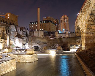
Mill Ruins Park is a park in downtown Minneapolis, Minnesota, United States, standing on the west side of Saint Anthony Falls on the Mississippi River and running from 3rd Ave. S. to about 9th Ave. S. The park interprets the history of flour milling in Minneapolis and shows the ruins of several flour mills that were abandoned.

Mill Hill is a historic neighborhood located within the city of Trenton in Mercer County, in the U.S. state of New Jersey. It is considered to be part of Downtown Trenton. The Mill Hill Historic District was added to the National Register of Historic Places in 1977.

The Southport Historic District in the town of Fairfield, Connecticut is a 225-acre (91 ha) area historic district that was listed on the National Register of Historic Places in 1971. It preserves a portion of the modern neighborhood and former borough of Southport, Connecticut. Since the British burnt almost all of Southport's structures in 1779, there is only one home built prior to that date, the Meeker House at 824 Harbor Road, which survives.

The Downtown Commercial Historic District in Muscatine, Iowa is a historic district that was listed on the National Register of Historic Places in 2006. At that time, it included 93 contributing buildings, one other contributing object, and 18 non-contributing buildings. The city of Muscatine was established as Bloomington in 1836. The original town was built on land that is generally flat along the Mississippi River. Residential areas were located on the surrounding hills. Commercial and industrial interests developed on the flatter land near the river. Muscatine's commercial and industrial center had developed in a 12-block area along Front Street, now Mississippi Drive, and 2nd Street between Pine Street and Mulberry Street by 1874. This area, represented by the Downtown Commercial Historic District, is the city's original commercial area. Within its boundaries is a large number of 19th-century commercial buildings, many of which were modified in the first half of the 20th century.

The Monson Center Historic District is a historic district encompassing the historic 19th century economic and civic heart of Monson, Massachusetts, a small town in eastern Hampden County. The district was listed on the National Register of Historic Places in 1991.

The West Hill Historic District in Muscatine, Iowa is a historic district that was listed on the National Register of Historic Places in 2008. At that time, it included 258 contributing buildings, two contributing objects, two contributing sites, and 67 non-contributing buildings. The city of Muscatine was established as Bloomington in 1836. The original town was built on land that is generally flat along the Mississippi River. Residential areas were built on the surrounding hills, while commercial and industrial interests developed on the flatter land near the river. The West Hill Historic District is immediately to the west of the Downtown Commercial Historic District. The period of significance for West Hill begins in 1839 and ends in 1958. Some of the largest and oldest historic houses in Muscatine are located here, but it also includes smaller residences of the working and middle class. By 1915, 180 of the historic houses had been built. The rest were built from 1916 to 1958. Another eight houses were built between 1960 and 1995. A majority of the houses (80%) are two stories in height. Frame construction (70%) outnumbers brick construction (30%). The architectural styles that were prominent across the country are also found here and were built at the time they were popular.

Meek's Flour Mill is a historic building located in Bonaparte, Iowa, United States. William Meek and Dr. R.N. Cresap laid out the town of Meek's Mill in 1837. Although the town was renamed Bonaparte in 1841, the Meek family had a central role in its development through the turn of the 20th-century. The present building is a three-story, gable roofed, rectangular structure that was built on a raised basement of ashlar limestone blocks. It was constructed in 1878 by William's son Robert, who had succeeded his father in running the family businesses. He was assisted by his brothers Isaiah and Joseph. It replaced the original 1844 mill, which had been destroyed in a fire. While built on the same site, it is unknown if any part of the present structure was a part of the original mill. Two other structures belonging to the Meek's family are located nearby: a woolen mill (1853), and a saw mill (1860).

Des Moines River Locks No. 5 and No. 7, also known as the Bonaparte and Keosauqua Locks, comprise a discontinuous historic site located along the Des Moines River in Van Buren County, Iowa, United States. Lock No. 5 is located in a riverfront park in Bonaparte, and lock No. 7 is located near Keosauqua. The locks are the only structures that are known to exist for the Des Moines River Improvement Project. Steamboats were the primary means of transportation into the interior of Iowa, but the river was only navigable at certain times of the year and that made the shipping season too short and unpredictable. In 1846 the Iowa Legislature conceived a plan to build a lock and dam system along the Des Moines River to make it navigable from the Mississippi River to the city of Des Moines. These two locks and a third at Bentonsport, non extant, were the only locks of the 28 planned locks and dams that were completed. The project ended in 1858 because it was mismanaged, and the Keokuk and Des Moines River Railroad was being developed to cover the same territory at the same time. Two dams had also been completed, but they have since been removed. Even though the project was never completed, navigation was possible via the locks as far upriver as Keosauqua.

The White, Munger and Company Store is a historic building located in Winterset, Iowa, United States. Built in 1861 by Evan V. Evans who owned the property the building sits on, it is an early example of a vernacular limestone commercial building. The two-story structure is composed of locally quarried ashlar and rubble stone. It features a false front that hides the gable roof, a parapet with a bracketed stone cornice and cornice return. The storefront has subsequently been altered. White, Munger and Company operated a woolen mill east of town, and this store was associated with the mill. The building was individually listed on the National Register of Historic Places in 1987, and it was included as a contributing property in the Winterset Courthouse Square Commercial Historic District in 2015.

The Waverly East Bremer Avenue Commercial Historic District is a nationally recognized historic district located in Waverly, Iowa, United States. It was listed on the National Register of Historic Places in 2014. At the time of its nomination it contained 53 resources, which included 41 contributing buildings, and 12 non-contributing buildings. The historic district covers a portion of the city's central business district between the Cedar River on the west and the former right-of-way for the Chicago Great Western Railway on the east.

The Marion Commercial Historic District is a nationally recognized historic district located in Marion, Iowa, United States. It was listed on the National Register of Historic Places in 2009. At the time of its nomination it consisted of 41 resources, which included 29 contributing buildings, one contributing site, one contributing structure, two contributing objects, and eight non-contributing buildings. The historic district covers the city's central business district. The development of this area largely occurred when Marion was the county seat of Linn County (1838-1919). There are no county government buildings extant from this era. The city was also a division point for the Chicago, Milwaukee, St. Paul and Pacific Railroad in the late nineteenth and early twentieth centuries.
The West Side Third Avenue SW Commercial Historic District is a nationally recognized historic district located in Cedar Rapids, Iowa, United States. It was listed on the National Register of Historic Places in 2014. At the time of its nomination it consisted of 10 resources, which included seven contributing buildings and three non-contributing buildings. Cedar Rapids was platted on the east bank of the Cedar River as Rapids City in 1841, and it was incorporated in 1849. Kingston was established on the west bank of the river in 1852, and it was annexed by Cedar Rapids in 1870. The streets were laid out parallel and perpendicular to the river, which flowed from the northwest to the southeast. The Chicago, Iowa & Nebraska Railway, later the Chicago & North Western Railway, was the prominent railroad on the west side of town. The first bridge across the river at Third Avenue was built in 1871. The current bridge was completed in 1912. Prior to a bridge, Rapid City and Kingston were connected by a ferry operated by David W. King, the founder of Kingston.

The Red Oak Downtown Historic District is a nationally recognized historic district located in Red Oak, Iowa, United States. It was listed on the National Register of Historic Places in 2016. At the time of its nomination it contained 104 resources, which included 73 contributing buildings, eight contributing objects, one contributing site, 15 non-contributing buildings, six non-contributing objects, and one non-contributing structure. The historic district covers most of the city's central business district. It is a flat area of land in an otherwise hilly region. The district is centered on Fountain Square, a public green space around which the town had been platted in 1857. A second public square was added in 1890 for the Montgomery County Courthouse after Red Oak won a special election to move the county seat from Frankfort.

The Corning Commercial Historic District is a nationally recognized historic district located in Corning, Iowa, United States. It was listed on the National Register of Historic Places in 2012. At the time of its nomination the district consisted of 78 resources, including 56 contributing buildings, one contributing site, one contributing object, 18 non-contributing buildings, and one non-contributing structure. The district covers most of the central business district. It has a linear layout, with twin main streets, associated with Central Park and the Adams County Courthouse at its uppermost end. This is an unusual town layout and is thought to be the only town in Iowa so configured. The elevation slopes down toward the East Nodaway River, south of the downtown and a light industrial area.

Middle Valley is an unincorporated community located along Middle Valley Road and County Route 513 in Washington Township, Morris County, New Jersey. It is located near Long Valley within the valley of the South Branch Raritan River. The Middle Valley Historic District was listed on the state and national registers of historic places in 1989 and 1990.
The Decorah Commercial Historic District is a nationally recognized historic district located in Decorah, Iowa, United States. It was listed on the National Register of Historic Places in 2017. At the time of its nomination it contained 126 resources, which included 85 contributing buildings, one contributing structure, and 40 non-contributing buildings. The historic district covers most of the city's central business district. Water Street, which is a major thoroughfare through the district was named after a millrace (non-extant) that rerouted water from the Upper Iowa River to serve the needs of the mills and the commercial district. The land here is relatively flat and allowed for a linear shopping area. The Broadway–Phelps Park Historic District is largely a residential area that is located to the south.

The Davenport Downtown Commercial Historic District is a nationally recognized historic district located in the central business district of Davenport, Iowa, United States. It was listed on the National Register of Historic Places in 2020. At the time of its nomination it consisted of 43 resources, which included 33 contributing buildings, one contributing structure, and nine non-contributing buildings. In addition, the district also contains 33 buildings that are individually listed on the National Register. This historic district is bordered by four other districts: the Crescent Warehouse Historic District and the Davenport Motor Row and Industrial Historic District on the east, the Hamburg Historic District to the northwest, and the West Third Street Historic District on the west.
The Clinton Historic District is a 175-acre (71 ha) historic district encompassing much of the town of Clinton in Hunterdon County, New Jersey. It was added to the National Register of Historic Places on September 28, 1995, for its significance in architecture, commerce, engineering, industry and exploration/settlement. The district includes 270 contributing buildings, one contributing structure, and three contributing sites. Five were previously listed on the NRHP individually: Dunham's Mill, M. C. Mulligan & Sons Quarry, Music Hall, Old Grandin Library, and Red Mill.
The Raritan–Readington South Branch Historic District is a 556-acre (225 ha) historic district along River Road from New Jersey Route 31 to U.S. Route 202 near Flemington in Hunterdon County, New Jersey. It is primarily on the western side of the South Branch Raritan River in Raritan Township. It extends onto the eastern side of the river in Readington Township. County Route 523 and County Route 612 pass through the district to the north. The district encompasses the small settlements of Holcomb Mills, Flemington Junction, and Rockefellows Mills. It was added to the National Register of Historic Places on January 26, 1990, for its significance in architecture, politics, transportation, and exploration/settlement. The district includes 36 contributing buildings, four contributing structures, and three contributing sites. It also includes the John Reading Farmstead, previously listed on the NRHP individually.


