National Register of Historic Places listings in Van Buren County, Iowa

Last updated

Location of Van Buren County in Iowa Map of Iowa highlighting Van Buren County.svg
Location of Van Buren County in Iowa

This is a list of the National Register of Historic Places listings in Van Buren County, Iowa.

Contents

This is intended to be a complete list of the properties and districts on the National Register of Historic Places in Van Buren County, Iowa, United States. Latitude and longitude coordinates are provided for many National Register properties and districts; these locations may be seen together in a map. [1]

There are 20 properties and districts listed on the National Register in the county. Another three properties were once listed, but have since been removed.


    This National Park Service list is complete through NPS recent listings posted June 24, 2022. [2]

Map all coordinates using: OpenStreetMap  
Download coordinates as: KML
[3] Name on the Register [4] ImageDate listed [5] Location City or townDescription
1 Aunty Green Hotel January 20, 1978
(#78001265)
602 Washington St.
40°41′55″N91°48′01″W / 40.698611°N 91.800278°W / 40.698611; -91.800278 (Aunty Green Hotel)
Bonaparte
2 Bentonsport
Bentonsport Bentonsport, Iowa.jpg
Bentonsport
April 25, 1972
(#72000482)
East of Keosauqua on the Des Moines River
40°43′32″N91°51′14″W / 40.725586°N 91.853780°W / 40.725586; -91.853780 (Bentonsport)
Keosauqua
3 Bonaparte Historic Riverfront District
Bonaparte Historic Riverfront District Bonaparte, Iowa.jpg
Bonaparte Historic Riverfront District
April 25, 1989
(#89000313)
Roughly bounded by 2nd St., Washington St., the Des Moines River, and Richard St.
40°41′53″N91°48′12″W / 40.698056°N 91.803333°W / 40.698056; -91.803333 (Bonaparte Historic Riverfront District)
Bonaparte
4 Bonaparte Pottery Archeological District
Bonaparte Pottery Archeological District Bonaparte Pottery.jpg
Bonaparte Pottery Archeological District
July 15, 1999
(#99000832)
411–419 1st St.
40°41′51″N91°48′00″W / 40.6975°N 91.8°W / 40.6975; -91.8 (Bonaparte Pottery Archeological District)
Bonaparte
5 Burg Wagon Works Building November 14, 1978
(#78001266)
131 S. 2nd St.
40°38′24″N91°44′30″W / 40.64°N 91.741667°W / 40.64; -91.741667 (Burg Wagon Works Building)
Farmington
6 Des Moines River Locks No. 5 and No. 7
Des Moines River Locks No. 5 and No. 7 Des Moines River P6070938.jpg
Des Moines River Locks No. 5 and No. 7
December 7, 1977
(#77000561)
At the Des Moines River
40°41′51″N91°48′17″W / 40.6975°N 91.804722°W / 40.6975; -91.804722 (Des Moines River Locks No. 5 and No. 7)
Bonaparte and Keosauqua
7 Eisenhower Bridge May 15, 1998
(#98000478)
3 miles east of County Road V56
40°40′43″N92°07′02″W / 40.678611°N 92.117222°W / 40.678611; -92.117222 (Eisenhower Bridge)
Milton
8 Hotel Manning
Hotel Manning KeosauquaIowa2.jpg
Hotel Manning
April 23, 1973
(#73000740)
River and Van Buren Sts.
40°43′47″N91°57′40″W / 40.729722°N 91.961111°W / 40.729722; -91.961111 (Hotel Manning)
Keosauqua
9 Kilbourn Bridge
Kilbourn Bridge Kilbourn Bridge.jpg
Kilbourn Bridge
May 15, 1998
(#98000477)
3 miles west of Iowa Highway 1
40°47′56″N91°58′14″W / 40.798889°N 91.970556°W / 40.798889; -91.970556 (Kilbourn Bridge)
Kilbourn
10 Lacey-Keosauqua State Park, Lodge and Picnic Area (Area A) November 15, 1990
(#90001668)
Off Iowa Highway 1 on the southern bank of the Des Moines River
40°43′20″N91°59′39″W / 40.722222°N 91.994167°W / 40.722222; -91.994167 (Lacey-Keosauqua State Park, Lodge and Picnic Area (Area A))
Keosauqua
11 Lacey-Keosauqua State Park, Picnic and Custodial Group (Area B) November 15, 1990
(#90001669)
Off Iowa Highway 1 on the southern bank of the Des Moines River
40°42′57″N91°58′23″W / 40.715833°N 91.973056°W / 40.715833; -91.973056 (Lacey-Keosauqua State Park, Picnic and Custodial Group (Area B))
Keosauqua
12 Lacey-Keosauqua State Park, Bathing Area (Area C)
Lacey-Keosauqua State Park, Bathing Area (Area C) Lacy Lake.jpg
Lacey-Keosauqua State Park, Bathing Area (Area C)
November 15, 1990
(#90001670)
Off Iowa Highway 1 on the southern bank of the Des Moines River
40°42′31″N91°58′14″W / 40.708611°N 91.970556°W / 40.708611; -91.970556 (Lacey-Keosauqua State Park, Bathing Area (Area C))
Keosauqua
13 Abner Martin House
Abner Martin House Abner Martin House 1979.jpg
Abner Martin House
April 12, 1984
(#84001604)
South of Mount Zion off Iowa Highway 1
40°46′31″N91°55′37″W / 40.775385°N 91.927082°W / 40.775385; -91.927082 (Abner Martin House)
Mount Zion
14 Meek's Flour Mill
Meek's Flour Mill Bonaparte Retreat P6070933.jpg
Meek's Flour Mill
January 27, 1983
(#83000406)
1st St.
40°41′52″N91°48′15″W / 40.697778°N 91.804167°W / 40.697778; -91.804167 (Meek's Flour Mill)
Bonaparte
15 Samuel and Mercy Paine House June 29, 2022
(#100007880)
27421 Cty. Rd. J40
40°43′28″N91°50′47″W / 40.724471°N 91.846313°W / 40.724471; -91.846313 (Samuel and Mercy Paine House)
Bentonsport vicinity
16 Franklin Pearson House
Franklin Pearson House Franklin Pearson House.jpg
Franklin Pearson House
May 22, 1978
(#78001267)
Dodge St.
40°44′08″N91°58′03″W / 40.735556°N 91.9675°W / 40.735556; -91.9675 (Franklin Pearson House)
Keosauqua
17 Voltaire Twombley Building
Voltaire Twombley Building Voltaire Twombley Building NRHP 93000655 Van Buren County, IA.jpg
Voltaire Twombley Building
July 29, 1993
(#93000655)
803 1st St.
40°43′52″N91°57′40″W / 40.731111°N 91.961111°W / 40.731111; -91.961111 (Voltaire Twombley Building)
Keosauqua
18 Van Buren County Courthouse
Van Buren County Courthouse VanBurenCoIowa1.jpg
Van Buren County Courthouse
November 9, 1977
(#77000562)
904 4th St.
40°44′00″N91°57′48″W / 40.733333°N 91.963333°W / 40.733333; -91.963333 (Van Buren County Courthouse)
Keosauqua
19 Vernon School
Vernon School Vernon School, Vernon, IA.jpg
Vernon School
September 12, 2002
(#02001024)
26849 South St.
40°43′17″N91°51′23″W / 40.721389°N 91.856389°W / 40.721389; -91.856389 (Vernon School)
Vernon
20 Wickfield Round Barn June 30, 1986
(#86001447)
Off Iowa Highway 2
40°40′04″N92°01′23″W / 40.667778°N 92.023056°W / 40.667778; -92.023056 (Wickfield Round Barn)
Cantril

Former listings

Other properties were once listed on the register, but were removed:

[3] Name on the RegisterImageDate listedDate removedLocationCity or townDescription
1 Goodin Building May 15, 2002
(#02000505)
March 7, 2016N. 106 Front St.
40°38′25″N91°44′38″W / 40.640278°N 91.743889°W / 40.640278; -91.743889 (Goodin Building)
Farmington
2 Keosauqua Bridge May 15, 1998
(#98000476)
September 10, 2008 Iowa Highway 1 over Des Moines River,
Keosauqua Replaced in 2006.
3 Midway Stock Farm Barn February 22, 1999
(#99000126)
January 31, 20190.3 miles south of the junction of Iowa Highways 1 and 16
40°48′09″N91°55′50″W / 40.8025°N 91.930556°W / 40.8025; -91.930556 (Midway Stock Farm Barn)
Keosauqua Destroyed by a tornado on July 19, 2018 [6] . [7]

See also

Related Research Articles

National Register of Historic Places listings in St. Joseph County, Michigan

This is a list of the National Register of Historic Places listings in St. Joseph County, Michigan.

National Register of Historic Places listings in Jefferson County, Ohio

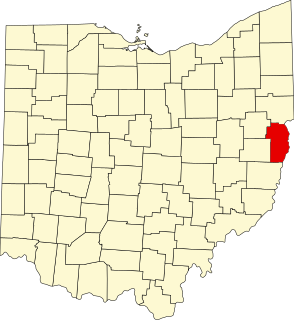
This is a list of the National Register of Historic Places listings in Jefferson County, Ohio.

National Register of Historic Places listings in Appanoose County, Iowa

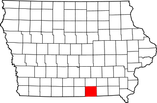
This is a list of the National Register of Historic Places listings in Appanoose County, Iowa.

National Register of Historic Places listings in Delaware County, Iowa

This is a list of the National Register of Historic Places listings in Delaware County, Iowa.

National Register of Historic Places listings in Davis County, Iowa

This is a list of the National Register of Historic Places listings in Davis County, Iowa.

National Register of Historic Places listings in Dallas County, Iowa

This is a list of the National Register of Historic Places listings in Dallas County, Iowa.

National Register of Historic Places listings in Dickinson County, Iowa

This is a list of the National Register of Historic Places listings in Dickinson County, Iowa.

National Register of Historic Places listings in Floyd County, Iowa

This is a list of the National Register of Historic Places listings in Floyd County, Iowa.

National Register of Historic Places listings in Henry County, Iowa

This is a list of the National Register of Historic Places listings in Henry County, Iowa.

National Register of Historic Places listings in Keokuk County, Iowa

This is a list of the National Register of Historic Places listings in Keokuk County, Iowa.

National Register of Historic Places listings in Jefferson County, Iowa

This is a list of the National Register of Historic Places listings in Jefferson County, Iowa.

National Register of Historic Places listings in Lee County, Iowa

This is a list of the National Register of Historic Places listings in Lee County, Iowa.

National Register of Historic Places listings in Johnson County, Iowa

This is a list of the National Register of Historic Places listings in Johnson County, Iowa.

National Register of Historic Places listings in Marshall County, Iowa

This is a list of the National Register of Historic Places listings in Marshall County, Iowa.

National Register of Historic Places listings in Mahaska County, Iowa

This is a list of the National Register of Historic Places listings in Mahaska County, Iowa.

National Register of Historic Places listings in Washington County, Iowa

This is a list of the National Register of Historic Places listings in Washington County, Iowa.

National Register of Historic Places listings in Wapello County, Iowa

This is a list of the National Register of Historic Places listings in Wapello County, Iowa.

National Register of Historic Places listings in Van Buren County, Arkansas

This is a list of the National Register of Historic Places listings in Van Buren County, Arkansas.

National Register of Historic Places listings in Fremont County, Iowa

This is intended to be a complete list of the properties and districts on the National Register of Historic Places in Fremont County, Iowa, United States. Latitude and longitude coordinates are provided for many National Register properties and districts; these locations may be seen together in a map.

National Register of Historic Places listings in Page County, Iowa

This is a list of the National Register of Historic Places listings in Page County, Iowa.

References

  1. The latitude and longitude information provided in this table was derived originally from the National Register Information System, which has been found to be fairly accurate for about 99% of listings. Some locations in this table may have been corrected to current GPS standards.
  2. National Park Service, United States Department of the Interior, "National Register of Historic Places: Weekly List Actions", retrieved June 24, 2022.
  3. 1 2 Numbers represent an alphabetical ordering by significant words. Various colorings, defined here, differentiate National Historic Landmarks and historic districts from other NRHP buildings, structures, sites or objects.
  4. "National Register Information System". National Register of Historic Places . National Park Service. April 24, 2008.
  5. The eight-digit number below each date is the number assigned to each location in the National Register Information System database, which can be viewed by clicking the number.
  6. "57. Midway Stock Farm Barn". Jefferson County, Iowa. Retrieved 2019-03-01.
  7. Iowa Event Report: EF1 Tornado (Report). National Centers for Environmental Information. National Weather Service Weather Forecast Office in Davenport, Iowa. 2018. Retrieved March 11, 2019.