National Register of Historic Places listings in Jefferson County, Iowa

Last updated
Location of Jefferson County in Iowa Map of Iowa highlighting Jefferson County.svg
Location of Jefferson County in Iowa

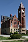
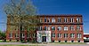
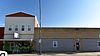
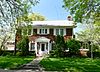
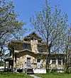
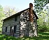
This is a list of the National Register of Historic Places listings in Jefferson County, Iowa.

Contents

This is intended to be a complete list of the properties and districts on the National Register of Historic Places in Jefferson County, Iowa, United States. Latitude and longitude coordinates are provided for many National Register properties and districts; these locations may be seen together in a map. [1]

National Register of Historic Places Federal list of historic sites in the United States

The National Register of Historic Places (NRHP) is the United States federal government's official list of districts, sites, buildings, structures and objects deemed worthy of preservation for their historical significance. A property listed in the National Register, or located within a National Register Historic District, may qualify for tax incentives derived from the total value of expenses incurred in preserving the property.

Jefferson County, Iowa U.S. county in Iowa

Jefferson County is a county located in the U.S. state of Iowa. As of the 2010 census, the population was 16,843. The county seat is Fairfield. The county was formed in January 1839, and was named after President Thomas Jefferson.

Iowa State in the United States

Iowa is a state in the Midwestern United States, bordered by the Mississippi River to the east and the Missouri River and Big Sioux River to the west. It is bordered by six states: Wisconsin to the northeast, Illinois to the east, Missouri to the south, Nebraska to the west, South Dakota to the northwest, and Minnesota to the north.

There are 29 properties and districts listed on the National Register in the county.

This National Park Service list is complete through NPS recent listings posted November 8, 2019. [2]
Map all coordinates using: OpenStreetMap  
Download coordinates as: KML  ·  GPX

Current listings

[3] Name on the Register [4] ImageDate listed [5] Location City or townDescription
1 Architecture of Henry K. Holsman Historic Campus District
Architecture of Henry K. Holsman Historic Campus District Ewing Hall, Parsons College.jpg
Architecture of Henry K. Holsman Historic Campus District
October 31, 1983
(#83003605)
Bounded by Merrill St., Iowa Highway 1, and Carter Memorial Dr.
41°00′58″N91°58′00″W / 41.016111°N 91.966667°W / 41.016111; -91.966667 (Architecture of Henry K. Holsman Historic Campus District)
Fairfield
2 W.C. Ball House
W.C. Ball House The W.C. Ball House.jpeg
W.C. Ball House
April 4, 1985
(#85000691)
Rural Route #2
41°01′11″N91°57′32″W / 41.019722°N 91.958889°W / 41.019722; -91.958889 (W.C. Ball House)
Fairfield
3 James A. Beck House
James A. Beck House Wooden Queen Anne house in Fairfield, Iowa.jpg
James A. Beck House
March 29, 1978
(#78001225)
401 E. Burlington Ave.
41°00′30″N91°57′47″W / 41.008333°N 91.963056°W / 41.008333; -91.963056 (James A. Beck House)
Fairfield Designed by architect George Franklin Barber
4 Burnett-Montgomery House
Burnett-Montgomery House The Burnett-Montgomery House.jpg
Burnett-Montgomery House
January 27, 1983
(#83000372)
605 N. 3rd St.
41°00′52″N91°57′55″W / 41.014444°N 91.965278°W / 41.014444; -91.965278 (Burnett-Montgomery House)
Fairfield
5 James F. Clarke House
James F. Clarke House Fairfield's Frank Llolyd Wright house from the North-East.jpg
James F. Clarke House
February 8, 1980
(#80001453)
500 S. Main St.
41°00′21″N91°58′00″W / 41.005833°N 91.966667°W / 41.005833; -91.966667 (James F. Clarke House)
Fairfield
6 Evergreen Ridge Stock Farm Historic District June 21, 2007
(#07000559)
2224 IA S
40°59′04″N91°57′55″W / 40.984476°N 91.965368°W / 40.984476; -91.965368 (Evergreen Ridge Stock Farm Historic District)
Fairfield
7 Fairfield Public Library
Fairfield Public Library Fairfield library.jpeg
Fairfield Public Library
May 23, 1983
(#83000373)
Court and Washington
41°00′29″N91°54′43″W / 41.008056°N 91.911944°W / 41.008056; -91.911944 (Fairfield Public Library)
Fairfield
8 Former US Post Office Building
Former US Post Office Building Former U.S. Post Office Building.jpeg
Former US Post Office Building
January 24, 1991
(#90002128)
110 S. Court St.
41°00′27″N91°57′43″W / 41.0075°N 91.961944°W / 41.0075; -91.961944 (Former US Post Office Building)
Fairfield
9 O.F. and Lulu E. Fryer House
O.F. and Lulu E. Fryer House The O.F. And Lulu E. Fryer House.jpeg
O.F. and Lulu E. Fryer House
February 5, 1999
(#99000131)
902 S. Main St.
40°59′32″N91°57′18″W / 40.992222°N 91.955°W / 40.992222; -91.955 (O.F. and Lulu E. Fryer House)
Fairfield
10 Fred and Rosa Fulton Barn
Fred and Rosa Fulton Barn Fred And Rosa Fulton Barn.jpeg
Fred and Rosa Fulton Barn
February 22, 1999
(#99000119)
1210 278th Boulevard
40°54′04″N92°08′18″W / 40.901111°N 92.138333°W / 40.901111; -92.138333 (Fred and Rosa Fulton Barn)
Selma
11 Gobble and Heer-Spurgeons Building
Gobble and Heer-Spurgeons Building Gobble and Heer-Spurgeons Building.jpeg
Gobble and Heer-Spurgeons Building
October 13, 2015
(#15000727)
51 E. Broadway
41°00′28″N91°57′47″W / 41.0077°N 91.9630°W / 41.0077; -91.9630 (Gobble and Heer-Spurgeons Building)
Fairfield
12 Henn Mansion
Henn Mansion Henn Mansion.jpeg
Henn Mansion
January 11, 1983
(#83000374)
Maharishi University of Management campus
41°01′00″N91°57′59″W / 41.0167°N 91.9664°W / 41.0167; -91.9664 (Henn Mansion)
Fairfield
13 Iowa Malleable Iron Company
Iowa Malleable Iron Company The Iowa Malleable Iron Company.jpeg
Iowa Malleable Iron Company
February 22, 1999
(#99000122)
600-608 N. 9th St.
41°00′47″N91°58′33″W / 41.013056°N 91.975833°W / 41.013056; -91.975833 (Iowa Malleable Iron Company)
Fairfield
14 Jefferson County Courthouse
Jefferson County Courthouse Jefferson County, Iowa Courthouse.jpg
Jefferson County Courthouse
July 2, 1981
(#81000250)
Court St. between Briggs and Hempstead Aves.
41°00′37″N91°57′55″W / 41.010278°N 91.965278°W / 41.010278; -91.965278 (Jefferson County Courthouse)
Fairfield
15 Louden Machinery Company
Louden Machinery Company The Louden Machinery Company.jpeg
Louden Machinery Company
February 22, 1999
(#99000128)
607 W. Broadway Ave.
41°00′32″N91°58′15″W / 41.008889°N 91.970833°W / 41.008889; -91.970833 (Louden Machinery Company)
Fairfield
16 Louden Monorail System in the Auto Repair Shop
Louden Monorail System in the Auto Repair Shop 117 E. Broadway former Auto Repair Shop.jpg
Louden Monorail System in the Auto Repair Shop
February 22, 1999
(#99000129)
117 E. Broadway Ave.
41°00′27″N91°57′43″W / 41.0075°N 91.961944°W / 41.0075; -91.961944 (Louden Monorail System in the Auto Repair Shop)
Fairfield
17 Louden Whirl-Around
Louden Whirl-Around The Louden Whirl-Around.jpg
Louden Whirl-Around
February 22, 1999
(#99000123)
905 E. Harrison Ave.
40°59′54″N91°57′06″W / 40.998333°N 91.951667°W / 40.998333; -91.951667 (Louden Whirl-Around)
Fairfield
18 R. B. and Lizzie L. Louden House
R. B. and Lizzie L. Louden House R.B. And Lizzie Louden House.jpeg
R. B. and Lizzie L. Louden House
February 22, 1999
(#99000125)
107 W. Washington Ave.
41°00′21″N91°57′53″W / 41.005833°N 91.964722°W / 41.005833; -91.964722 (R. B. and Lizzie L. Louden House)
Fairfield
19 R. Bruce and May W. Louden House
R. Bruce and May W. Louden House The R. Bruce and May W. Louden House.jpg
R. Bruce and May W. Louden House
September 12, 2003
(#99000124)
501 W. Adams Ave.
41°00′18″N91°58′09″W / 41.005°N 91.969167°W / 41.005; -91.969167 (R. Bruce and May W. Louden House)
Fairfield
20 R.R. and Antoinette Louden House
R.R. and Antoinette Louden House R.R. And Antoinette Louden House.jpeg
R.R. and Antoinette Louden House
February 22, 1999
(#99000130)
905 E. Adams Ave.
41°00′17″N91°57′05″W / 41.004722°N 91.951389°W / 41.004722; -91.951389 (R.R. and Antoinette Louden House)
Fairfield
21 William and Mary Jane Louden House
William and Mary Jane Louden House The William and Mary Jane Louden House.jpeg
William and Mary Jane Louden House
February 18, 1999
(#99000118)
501 W. Washington Ave.
41°00′22″N91°58′09″W / 41.006111°N 91.969167°W / 41.006111; -91.969167 (William and Mary Jane Louden House)
Fairfield
22 August and Vera Luedtke Barn February 22, 1999
(#99000121)
1938 185th St.
41°02′17″N91°59′57″W / 41.038056°N 91.999167°W / 41.038056; -91.999167 (August and Vera Luedtke Barn)
Fairfield
23 McElhinny House
McElhinny House McElhinny House.jpeg
McElhinny House
December 19, 1977
(#77000524)
300 N. Court St.
41°00′43″N92°02′25″W / 41.011944°N 92.040278°W / 41.011944; -92.040278 (McElhinny House)
Fairfield
24 New Sweden Chapel
New Sweden Chapel The New Sweden Chapel.jpeg
New Sweden Chapel
March 25, 1977
(#77000525)
East of Fairfield off U.S. Route 34
41°01′22″N91°46′47″W / 41.022778°N 91.779722°W / 41.022778; -91.779722 (New Sweden Chapel)
Fairfield
25 Old Settlers' Association Park and Rhodham Bonnifield House
Old Settlers' Association Park and Rhodham Bonnifield House Rhodham Bonnifield House.jpeg
Old Settlers' Association Park and Rhodham Bonnifield House
August 14, 1986
(#86001601)
B St.
41°01′08″N91°57′24″W / 41.018889°N 91.956667°W / 41.018889; -91.956667 (Old Settlers' Association Park and Rhodham Bonnifield House)
Fairfield
26 George A. Wells House
George A. Wells House The George A. wells House.jpeg
George A. Wells House
January 27, 1983
(#83000375)
304 S. Main St.
41°00′15″N91°57′50″W / 41.004167°N 91.963889°W / 41.004167; -91.963889 (George A. Wells House)
Fairfield
27 Wells-Stubbs House
Wells-Stubbs House The Wells-Stubbs Houseq, Fairfield, Iowa.jpg
Wells-Stubbs House
October 10, 1985
(#85003000)
508 E. Burlington Ave.
41°00′56″N91°57′22″W / 41.015556°N 91.956111°W / 41.015556; -91.956111 (Wells-Stubbs House)
Fairfield
28 Wilson Building
Wilson Building The Wilson Building, Fairfield Iowa.jpeg
Wilson Building
January 24, 1991
(#90002129)
106-108 S. Court St.
41°00′28″N91°57′40″W / 41.007778°N 91.961111°W / 41.007778; -91.961111 (Wilson Building)
Fairfield
29 US Senator James F. Wilson House
US Senator James F. Wilson House U.S. Senator James F. Wilson House.jpeg
US Senator James F. Wilson House
January 24, 1991
(#90002130)
805 S. Main St.
40°59′44″N91°57′45″W / 40.995556°N 91.9625°W / 40.995556; -91.9625 (US Senator James F. Wilson House)
Fairfield

See also

National Register of Historic Places listings in Iowa Wikimedia list article

This is a list of properties and historic districts in Iowa that are listed on the National Register of Historic Places. There are listings in all of Iowa's 99 counties, adding up to over 2,300 total.

Related Research Articles

National Register of Historic Places listings in Jefferson County, New York Wikimedia list article

List of the National Register of Historic Places listings in Jefferson County, New York

National Register of Historic Places listings in Scott County, Iowa Wikimedia list article

This is intended to be a complete list of the properties and districts on the National Register of Historic Places in Scott County, Iowa, United States. Latitude and longitude coordinates are provided for many National Register properties and districts; these locations may be seen together in a map.

National Register of Historic Places listings in Jefferson County, Ohio Wikimedia list article

This is a list of the National Register of Historic Places listings in Jefferson County, Ohio.

National Register of Historic Places listings in Black Hawk County, Iowa Wikimedia list article

Here is presented a listing of the National Register of Historic Places in Black Hawk County, Iowa.

National Register of Historic Places listings in Cedar County, Iowa Wikimedia list article

This is a list of the National Register of Historic Places listings in Cedar County, Iowa.

National Register of Historic Places listings in Clinton County, Iowa Wikimedia list article

This is a list of the National Register of Historic Places listings in Clinton County, Iowa.

National Register of Historic Places listings in Dubuque County, Iowa Wikimedia list article

This is a list of the National Register of Historic Places listings in Dubuque County, Iowa.

National Register of Historic Places listings in Iowa County, Iowa Wikimedia list article

This is a list of the National Register of Historic Places listings in Iowa County, Iowa.

National Register of Historic Places listings in Henry County, Iowa Wikimedia list article

This is a list of the National Register of Historic Places listings in Henry County, Iowa.

National Register of Historic Places listings in Jones County, Iowa Wikimedia list article

This is a list of the National Register of Historic Places listings in Jones County, Iowa.

National Register of Historic Places listings in Lee County, Iowa Wikimedia list article

This is a list of the National Register of Historic Places listings in Lee County, Iowa.

National Register of Historic Places listings in Johnson County, Iowa Wikimedia list article

This is a list of the National Register of Historic Places listings in Johnson County, Iowa.

National Register of Historic Places listings in Lyon County, Iowa Wikimedia list article

This is a list of the National Register of Historic Places listings in Lyon County, Iowa.

National Register of Historic Places listings in Polk County, Iowa Wikimedia list article

This is a list of the National Register of Historic Places listings in Polk County, Iowa.

National Register of Historic Places listings in Winneshiek County, Iowa Wikimedia list article

This is a list of the National Register of Historic Places listings in Winneshiek County, Iowa.

National Register of Historic Places listings in Woodbury County, Iowa Wikimedia list article

This is a list of the National Register of Historic Places listings in Woodbury County, Iowa.

National Register of Historic Places listings in Story County, Iowa Wikimedia list article

This is a list of the National Register of Historic Places listings in Story County, Iowa.

National Register of Historic Places listings in Jefferson County, Indiana Wikimedia list article

This is a list of the National Register of Historic Places listings in Jefferson County, Indiana.

National Register of Historic Places listings in Birmingham, Alabama Wikimedia list article

This is a list of the National Register of Historic Places listings in Birmingham, Alabama.

National Register of Historic Places listings in Jefferson County, Missouri Wikimedia list article

This is a list of the National Register of Historic Places listings in Jefferson County, Missouri.

References

  1. The latitude and longitude information provided in this table was derived originally from the National Register Information System, which has been found to be fairly accurate for about 99% of listings. Some locations in this table may have been corrected to current GPS standards.
  2. "National Register of Historic Places: Weekly List Actions". National Park Service, United States Department of the Interior. Retrieved on November 8, 2019.
  3. Numbers represent an ordering by significant words. Various colorings, defined here, differentiate National Historic Landmarks and historic districts from other NRHP buildings, structures, sites or objects.
  4. "National Register Information System". National Register of Historic Places . National Park Service. April 24, 2008.
  5. The eight-digit number below each date is the number assigned to each location in the National Register Information System database, which can be viewed by clicking the number.