Related Research Articles

Washington County is a county located in the U.S. state of Iowa. As of the 2020 census, the population was 22,565. The county seat is Washington.

Jones County is a county in the U.S. state of Iowa. As of the 2020 census the population was 20,646. The county seat is Anamosa. The county was founded in 1837 and named after George Wallace Jones, a United States senator and member of Congress.

Jefferson County is a county located in the U.S. state of Iowa. As of the 2020 United States Census, the population was 15,663. The county seat is Fairfield.

Ely is a city in Linn County, Iowa. The population was 2,328 at the time of the 2020 census. It is part of the Cedar Rapids metropolitan area

Trout Lake Township is located in north central Minnesota in Itasca County, United States. It is bordered by the City of Coleraine to the west and north, City of Bovey on the north, an unorganized township on the east, and Blackberry Township to the south. Town government was adopted on March 6, 1894. The population was 1,056 at the 2020 census.
Donegal Township is a township in Westmoreland County, Pennsylvania, United States. The population was 2,192 at the 2020 census, a decrease of 9% compared to 2010.

Canoe Creek State Park is a 911.91-acre (369.04 ha) Pennsylvania state park in Frankstown Township in Blair County, Pennsylvania. It is 12 miles east of Altoona, the nearest city. Canoe Lake, at 155 acres (63 ha), is the focus of recreation at the park and is open for fishing year-round. Canoe Creek State Park is a half mile off U.S. Route 22 near the small town of Canoe Creek. The park was opened to the public in 1979 and was developed as part of an expansion effort in the 1970s to improve the state park system in Pennsylvania.
Summit Metro Parks is a Metroparks system serving the citizens of Summit County, Ohio by managing 14,000 acres (5,700 ha) in 16 developed parks, six conservation areas and more than 150 miles (240 km) of trails, with 22.4 miles (36.0 km) of the Ohio & Erie Canal Towpath Trail.
The Cache River is a 92-mile-long (148 km) waterway in southernmost Illinois, in a region sometimes called Little Egypt. The basin spans 737 square miles (1,910 km2) and six counties: Alexander, Johnson, Massac, Pope, Pulaski, and Union. Located at the convergence of four major physiographic regions, the river is part of the largest complex of wetlands in Illinois. The Cache River Wetlands is America's northernmost cypress/tupelo swamp and harbors 91 percent of the state's high quality swamp and wetland communities. It provides habitat for more than 100 threatened and endangered species in Illinois. In 1996, the Cache was designated a Wetland of International Importance under the Ramsar Convention.
The Columbus and Franklin County Metro Parks are a group of 20 metropolitan parks in and around Columbus, Ohio. They are officially organized into the Columbus and Franklin County Metropolitan Park District. The Metro Parks system was organized in 1945 under Ohio Revised Code Section 1545 as a separate political division of the state of Ohio. The Metro Parks are overseen by a Board of Park Commissioners consisting of three citizens appointed to three-year terms without compensation by the Judge of the Probate Court of Franklin County, Ohio. The Board in turn appoints an Executive Director responsible for operations and management of the parks.
Pioneers Park Nature Center, established in 1963, is a 668-acre (2.70 km2) nature preserve located within Pioneers Park, which is located at the intersections of South Coddington and West Van Dorn Streets in Lincoln, Nebraska. Both Pioneers Park and the Nature Center within it are operated by the Lincoln Parks and Recreation Department.
Newton Township is one of sixteen townships in Buchanan County, Iowa, United States. As of the 2000 census, its population was 423.
Northern Tallgrass Prairie National Wildlife Refuge was established to provide a means of working with individuals, groups, private organizations, and government entities to permanently preserve a portion of the remaining remnant tracts of northern tallgrass prairie in Minnesota and Iowa. The United States Fish and Wildlife Service is acquiring remnant prairie tracts for the refuge in both easement and fee title interests from willing sellers.
The College Community School District is a public school district serving communities of Linn, Johnson, and Benton counties in east central Iowa. The district was established in 1954 after the consolidation of several township schools. Based on a 381-acre (154 ha) campus in the southern part of Cedar Rapids, the district encompasses 137 square miles (350 km2) including the communities of Walford, Fairfax, Swisher, Shueyville, Ely, Southwest Cedar Rapids, and surrounding areas.
The Wilderness Center (TWC) is a 501(c)3 nonprofit nature center that operates its headquarters in Wilmot, Ohio, located in southwest Stark County, Ohio. It includes an interpretive building, astronomy education building, an observation tower, pier and picnic shelters. TWC's 10 miles of trails go through forest, prairie and along streams and creeks and past ponds and Wilderness Lake. TWC also maintains hiking trails on its Zoar Woods satellite property in northeast Tuscarawas County, Ohio. TWC owns or holds conservation easements on other tracts of land throughout a six-county area. TWC preserves these lands in forested or agricultural condition.

Cayler Prairie State Preserve is a 160-acre land parcel of tallgrass prairie located in the northwest region of the U.S. state of Iowa in Dickinson County near Spirit Lake. It is a National Natural Landmark.
Cedar Township is a township in Jefferson County, Iowa, United States.
Cedar Township is a township in Van Buren County, Iowa, USA.
Stephens State Forest is a state forest located in Lucas, Clarke, Monroe, Appanoose and Davis Counties in Iowa. Stephens State Forest is 15,500 acres and split into 7 separate locations that collectively make up the largest state forest in Iowa.
References
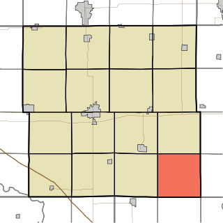
- ↑ U.S. Geological Survey Geographic Names Information System: Round Prairie Township, Jefferson County, Iowa
- ↑ "Round Prairie Park – Jefferson County Conservation" . Retrieved January 8, 2021.
- ↑ "Cedar Creek Timber & Wetland – Jefferson County Conservation" . Retrieved January 8, 2021.
Municipalities and communities of Jefferson County, Iowa, United States | ||
|---|---|---|
| Cities |  | |
| Townships | ||
| Unincorporated communities | ||
| Footnotes | ‡This populated place also has portions in an adjacent county or counties | |
40°57′N91°47′W / 40.950°N 91.783°W
| | This article about the geography of Jefferson County, Iowa is a stub. You can help Wikipedia by expanding it. |