
Sky Meadows State Park is a 1,862-acre (754 ha) park in the Virginia state park system. It is located in extreme northwest Fauquier County, Virginia in the Blue Ridge Mountains, near Paris, Virginia. It is about an hour outside of the Washington, D.C. metro region.

The University of Illinois Experimental Dairy Farm Historic District, also known as South Farm, is a designated historic district in the U.S. state of Illinois. It is located on the campus of the University of Illinois in Urbana, Illinois. The district consists of eight contributing structures and several non-contributing structures. The district was designated in 1994 when it was added to the National Register of Historic Places as part of the Multiple Property Submission concerning Round Barns in Illinois. Three of the district's buildings are early 20th century round barns constructed between 1908 and 1912. The district covers a total area of 6 acres (2 ha).
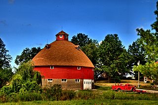
The three University of Illinois round barns played a special role in the promotion and popularity of the American round barn. They are located in Urbana Township, on the border of the U.S. city of Urbana, Illinois and on the campus of the University of Illinois at Urbana–Champaign. The University of Illinois was home to one of the Agricultural Experiment Stations, located at U.S. universities, which were at the heart of the promotion of the round barn. At least one round barn in Illinois was built specifically after its owner viewed the barns at the university. Though originally an experiment the three barns helped to lead the way for round barn construction throughout the Midwest, particularly in Illinois. The barns were listed as contributing properties to the U of I Experimental Dairy Farm Historic District, which was listed on the U.S. National Register of Historic Places in 1994.

Backbone State Park is Iowa's oldest state park, dedicated in 1919. Located in the valley of the Maquoketa River, it is approximately three miles (5 km) south of Strawberry Point in Delaware County. It is named for a narrow and steep ridge of bedrock carved by a loop of the Maquoketa River originally known as the Devil's Backbone. The initial 1,200 acres (490 ha) were donated by E.M. Carr of Lamont, Iowa. Backbone Lake Dam, a relatively low dam built by the Civilian Conservation Corps (CCC) in the 1930s, created Backbone Lake. The CCC constructed a majority of trails and buildings which make up the park.

Oxon Cove Park and Oxon Cove Farm is a national historic district that includes a living farm museum operated by the National Park Service, and located at Oxon Hill, Prince George's County, Maryland. It is part of National Capital Parks-East. It was listed on the National Register of Historic Places in 2003.

The Faeth Farmstead and Orchard District is a nationally recognized historic district located near Fort Madison, Iowa, United States. At the time of its nomination it contained 27 resources, which included 15 contributing buildings, three contributing sites, three contributing structures, and six non-contributing buildings. The contributing buildings include the farm house (c.1873), the main barn (1882), a stable, a privy, engine house, smokehouse, chicken house, and hog house all from the early 1900s, a shop/crib, a second barn (1925), an apple packing shed, an apple cold storage shed or cooler with loading dock, a truck shed (late1940s), a garage (1950s) and a machine shed. The contributing structures include a pond that was used for spraying apples (c.l936), a spray tank/house (1946), and an old section of road. The contributing sites are the three historic orchards. The East Orchard was established before 1874 and it still has remnant older trees. The Old North Orchard was established around the turn of the 20th-century, but the trees were primarily planted in the 1970s and the 1980s. The North Orchard was established in 1940-1941 and includes some remnant older trees and replacement trees from the 1970s to the 1990s. The non-contributing buildings are more recently built, or moved here in recent years.

The Louden Machinery Company was an American engineering, manufacturing and design company based in Fairfield, Iowa. Founded by William Louden, the company in its early years manufactured and sold the patented hay carrier that he invented in 1867. The company later expanded into a wide variety of farm equipment and, in 1906, began an Architecture Department that reportedly designed more than 25,000 barns from 1906 to 1939. During World War I, Louden's monorail equipment carrier began to be applied to industrial and military applications. By the 1920s, much of the company's revenues were derived from industrial applications of its monorail equipment carriers.

Squire Cheyney Farm is a historic farm and national historic district located in Thornbury Township, Chester County, Pennsylvania. The district encompasses two contributing buildings, three contributing sites, one contributing structure, and contributing object. They are the farmhouse, barn, ruins of a granary, remains of an ice house, a spring house (1799), stone retaining wall, and family cemetery. The house was built in four periods, with the oldest dated to about 1797. The oldest section is a 2 1/s-story, three bay, stuccoed stone structure with a gable roof. The additions were built about 1815, about 1830, and about 1850, making it a seven-bay-wide dwelling. It is "L"-shaped and has a slate gable roof. During the American Revolution, Thomas "Squire" Cheyney [II] informed General George Washington during the Battle of Brandywine that the British were flanking him to the north. He was later appointed to the Pennsylvania Ratifying Convention to ratify the United States Constitution. The site is now a township park known as Squire Cheyney Farm Park.

Tyden Farm No. 6 Farmstead Historic District is an agricultural historic district located east of Dougherty, Iowa, United States. It was listed on the National Register of Historic Places in 2009.
Orie J. Smith Black and White Stock Farm Historic District is a historic farm and national historic district located near Kirksville, Adair County, Missouri. The district encompasses six contributing buildings and one contributing structures on a farm about three miles northeast of Kirksville. It developed between 1910 and 1919, and features a round bank barn with a self-supporting dome roof, constructed in 1913. The other contributing resources in the district are the farmhouse, an American Foursquare with Prairie School affinities (1917), a granary (1910), a poultry house (1918) and two ice houses, and a concrete bridge (1914)

Brehe Farmstead Historic District, also known as the Fairview Stock Farm, is a historic home, farm, and national historic district located at Washington, Franklin County, Missouri. The farmhouse was built about 1869, and is a two-story brick dwelling. The other contributing buildings are the brick smokehouse/ dwelling combination, a frame poultry house (1940s), a large frame granary, a Quonset barn, a small frame milk house, and a large gambrel roofed bank barn with a round ceramic block silo.
Briggs Terrace, also known as Evergreen Lane, is a nationally recognized historic district located in Nevada, Iowa, United States. It was listed on the National Register of Historic Places in 1998. At the time of its nomination it consisted of eight resources, which included six contributing buildings, one contributing site, and two non-contributing buildings. This estate was established and built by Otis Briggs, a local banker who founded Farmers Bank in Nevada. He arrived in town in 1857 from Des Moines, four years after Nevada and Story County were founded. He worked in a variety of commercial ventures before becoming a banker. Briggs invested heavily in real estate, and he became one of the largest land owners in the county.

Walter Klepzig Mill and Farm is a historic farm and sawmill and national historic district located in the Ozark National Scenic Riverways near Eminence, Shannon County, Missouri. The district encompasses three contributing buildings, three contributing sites, and one contributing structure associated with an early-20th century Ozark farm and mill. It developed between about 1912 and 1936 and includes the mill and its related hydraulic system ; a spring house and smokehouse ; foundations of a 1923 farmhouse and barn ; and two post-1934 chicken coops and a ruin of a post-1934 machine shed.

The Evergreen Corner Rural Historic District in Haxtun, Colorado is a 160-acre (0.65 km2) farm property, a historic district that was listed on the National Register of Historic Places in 2013.

The Jan F. and Antonie Janko Farmstead District is an agricultural historic district located west of Ely, Iowa, United States. It was listed on the National Register of Historic Places in 2000. At the time of its nomination it consisted of seven resources, which included five contributing buildings, one contributing structure, and one non-contributing structure. The historic buildings include a two-story, wood frame, side gable house (1887); a gabled basement barn ; a gabled barn (1893); chicken house, and a single-stall garage (1910s-1930s). The corncrib is the historic structure. A three-stall garage (1972) is the non-contributing structure. The farmstead is located on a hilltop and sideslope. The house sits on the highest elevation, with the outbuildings located down the slope to the west and southwest.
The Josias L. and Elizabeth A. Minor Farmstead District is an agricultural historic district located northwest of Ely, Iowa, United States. It was listed on the National Register of Historic Places in 2000. At the time of its nomination it consisted of five resources, which included four contributing buildings and one non-contributing structure. The historic buildings include a 1½-story, T-plan, half-timbered house (1856); gabled barn #1 ; gabled barn #2 ; and the summer kitchen (1850s). The corncrib is the historic structure. Family lore says that Josias Minor settled here in 1846, but an 1878 biography of him gives September 1855 as the settlement date, which is used here for dating the buildings.

The Podhajsky-Jansa Farmstead District is an agricultural historic district located southwest of Ely, Iowa, United States. It was listed on the National Register of Historic Places in 2000. At the time of its nomination it consisted of 12 resources, which included five contributing buildings, four contributing structures, and three non-contributing structures. The historic buildings include two small side gabled houses ; a two-story, frame, American Foursquare house ; a gabled barn that was moved here from another farm ; and a feeder barn. One of two corncribs (1933), a hog house, and a chicken house are the historic structures. Another corncrib and a couple of metal sheds from the mid to late 20th century are the non-contributing structures.
The Hardin County Home Historic District, also known as Hardin County Poor Farm, Hardin County Farm, and the Hardin County Care Facility, is a nationally recognized historic district located northwest of Eldora, Iowa, United States. It was listed on the National Register of Historic Places in 2010. At the time of its nomination the district consisted of six resources, including three contributing buildings, one contributing site, and two non-contributing buildings. Beginning in the mid-19th century county homes were established across the state to take care of less fortunate residents. That care then extended to the end of the 20th century. The Hardin County Home operated at this location from 1877 to 1996. The historic district encompasses the buildings, farm fields, and cemetery associated with the home. The first burial in the cemetery, located on the southwest corner of the property, was in 1877. The graves are marked with simple stone markers. The last burial was in 2008. Farm fields surround the buildings and extend to the north.

The Anna and Mikko Pyhala Farm is a historic farmstead in Embarrass, Minnesota, United States, now preserved as a visitor attraction. It was established by a Finnish-American family in 1909 and includes seven surviving buildings, including several constructed with traditional Finnish log architecture, and the ruins of a prior settler's log cabin dating to around 1895. The farm was listed as a historic district on the National Register of Historic Places in 2003 for its state-level significance in the themes of agriculture, architecture, and European ethnic heritage. It was nominated for being one of St. Louis County's best examples of a Finnish-American farm with log architecture, and for its association with Finnish immigration to northeast Minnesota and the conversion of its cutover forests into productive farmland.

The Gregorius and Mary Hanka Farmstead is a historic farmstead in Embarrass Township, Minnesota, United States. It was established by a Finnish immigrant family around 1910 and includes four surviving buildings constructed with traditional Finnish log architecture. The farm was listed as a historic district on the National Register of Historic Places in 1990 for its state-level significance in the themes of agriculture, architecture, and European ethnic heritage. It was nominated for reflecting the successful conversion of St. Louis County's cutover forests into productive agricultural land by Finnish immigrants, and their use of traditional log architecture.


