
The Mississippi River is the second-longest river and chief river of the second-largest drainage system on the North American continent, second only to the Hudson Bay drainage system. From its traditional source of Lake Itasca in northern Minnesota, it flows generally south for 2,340 miles (3,770 km) to the Mississippi River Delta in the Gulf of Mexico. With its many tributaries, the Mississippi's watershed drains all or parts of 32 U.S. states and two Canadian provinces between the Rocky and Appalachian mountains. The main stem is entirely within the United States; the total drainage basin is 1,151,000 sq mi (2,980,000 km2), of which only about one percent is in Canada. The Mississippi ranks as the fourteenth-largest river by discharge in the world. The river either borders or passes through the states of Minnesota, Wisconsin, Iowa, Illinois, Missouri, Kentucky, Tennessee, Arkansas, Mississippi, and Louisiana.

Saint Anthony Falls, or the Falls of Saint Anthony located at the northeastern edge of downtown Minneapolis, Minnesota, is the only natural major waterfall on the Mississippi River. In the late 1870s, the natural face of the falls was reinforced with a sloping timber apron to stop the upstream progression of the falls. In the 1950s the apron was rebuilt with concrete which is the very visible spillway. A series of locks were constructed in the 1950s and 1960s to extend navigation to points upstream.

The Champlain Canal is a 60-mile (97 km) canal that connects the south end of Lake Champlain to the Hudson River in New York. It was simultaneously constructed with the Erie Canal and is now part of the New York State Canal System and the Lakes to Locks Passage.

Lock and Dam No. 12 is a lock and dam located on the Upper Mississippi River at Bellevue, Iowa, United States. The movable portion of the dam starts at the locks adjacent to the Iowa shore and is 849 feet (258.8 m) long, consisting of seven tainter gates and three roller gates. It connects to a 200-foot (61.0 m) storage yard and continues toward the Illinois shore with a 2,750-foot (838.2 m) non-submersible dike, a 1,200-foot (365.8 m) submersible dike and a 3,130-foot (954.0 m) non-submersible dike. The non-submersible sections are separated from the submersible section with two 120-foot (36.6 m) transitional dikes. The main lock is 110 feet (33.5 m) wide by 600 feet (182.9 m) long. There is also an incomplete auxiliary lock. In 2004, the facility was listed in the National Register of Historic Places as Lock and Dam No. 12 Historic District, #04000172 covering 1,017 acres (4.1 km2), 1 building, 3 structures, and 4 objects.

Lock and Dam No. 13 is a lock and dam located on the Upper Mississippi River above Fulton, Illinois and Clinton, Iowa, United States. This facility offers visitors a view of the barges and boats locking through on the widest pool in the Upper Mississippi River.

Lock and Dam No. 14 is a lock and dam located near LeClaire, Iowa on the Upper Mississippi River above Davenport, Iowa and Moline, Illinois. The movable portion of the dam is 1,343 feet (409.3 m) long and consists of 13 tainter gates and 4 roller gates. Connected to it is a 1,127 feet (343.5 m) long non-submersible rock fill dike which extends to the Illinois side. The main lock is 110 feet (33.5 m) wide by 600 feet (182.9 m) long. The site on the National Register of Historic Places as the Lock and Dam No. 14 Historic District (#04000174) listed in 2004 consisting of 3,043 acres (12.3 km2), 1 building, 6 structures, and 2 objects. It was completed in two phases, the first as part of the six foot channel project from 1921 to 1924, which included a lock and canal bypassing a hazardous rapids. The second phase was part of the nine foot channel project from 1935 to 1939 and included the main dam and the current main lock.

Lock and Dam No. 15 is a lock and dam located on the Upper Mississippi River. It spans the river between Rock Island, Illinois and Davenport, Iowa. Lock and Dam 15 is the largest roller dam in the world, its dam is 1,203 feet (366.7 m) long and consists of nine 109 feet (33.2 m) non-submersible, non-overflow roller gates and two 109 feet (33.2 m) non-submersible overflow roller gates. It is unusual among the upper Mississippi River dams in that it has only roller gates, has different sizes and types of roller gates, it is not perpendicular to the flow of the river and is one of the few facilities that has a completed auxiliary lock. The main lock is 110 feet (33.5 m) wide by 600 feet (180 m) long and its auxiliary lock is 110 feet (34 m) wide by 360 feet (110 m) long. In 2004, the facility was listed in the National Register of Historic Places as Lock and Dam No. 15 Historic District, #04000175 covering 3,590 acres (1,450 ha), 2 buildings, 9 structures, and 1 object.

Lock and Dam No. 19 is a lock and dam located on the Upper Mississippi River near Keokuk, Iowa. In 2004, the facility was listed in the National Register of Historic Places as Lock and Dam No. 19 Historic District, #04000179 covering 1,605 acres (650 ha), 7 buildings, 12 structures, 1 object. The lock is owned and operated by the U.S. Army Corps of Engineers. The dam is owned and operated by Ameren Missouri.

The Des Moines Rapids between Nauvoo, Illinois and Keokuk, Iowa-Hamilton, Illinois is one of two major rapids on the Mississippi River that limited Steamboat traffic on the river through the early 19th century.

The Cumberland and Oxford Canal was opened in 1832 to connect the largest lakes of southern Maine with the seaport of Portland, Maine. The canal followed the Presumpscot River from Sebago Lake through the towns of Standish, Windham, Gorham, and Westbrook. The Canal diverged from the river at Westbrook to reach the navigable Fore River estuary and Portland Harbor. The canal required 27 locks to reach Sebago Lake at an elevation of 267 feet (81 m) above sea level. One additional lock was constructed in the Songo River to provide 5 feet (1.5 m) of additional elevation to reach Long Lake from Sebago Lake. Total navigable distance was approximately 38 miles (61 km) from Portland to Harrison at the north end of Long Lake. A proposed extension from Harrison to Bear Pond and Tom Pond in Waterford would have required three more locks on the Bear River, but they were never built.

The Cascade Locks and Canal was a navigation project on the Columbia River between the U.S. states of Oregon and Washington, completed in 1896. It allowed the steamboats of the Columbia River to bypass the Cascades Rapids, and thereby opened a passage from the lower parts of the river as far as The Dalles. The locks were submerged and rendered obsolete in 1938, when the Bonneville Dam was constructed, along with a new set of locks, a short way downstream.
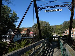
Bentonsport, a village on the Des Moines River near Keosauqua, in Van Buren County, Iowa, was recognized in 1972 for being very little changed since its historic heyday as a thriving steamboat port in the mid-1800s. A 35-acre (14 ha) historic district covering 16 original blocks in the historic center of the village was then approved for listing on the National Register of Historic Places. The district also included waterfront property and the village's historic wagon bridge across the river to the village of Vernon.

Starved Rock Lock and Dam, also known as Lock and Dam No. 6, is a lock and dam facility managed by the U.S. Army Corps of Engineers along the Illinois River. It is part of the Illinois Waterway and was constructed between 1926 and 1933. The lock and dam was added to the National Register of Historic Places as the Starved Rock Lock and Dam Historic District in 2004.

The Kaukauna Locks Historic District is a lock and dam system in Kaukauna, Wisconsin, United States that carried boat traffic around a rapids of the Fox River starting in the 1850s as part of the Fox–Wisconsin Waterway. It was added to the National Register of Historic Places in 1993 for its significance in engineering and transport.
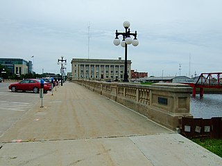
The Civic Center Historic District is located in downtown Des Moines, Iowa, United States. It flanks both the Des Moines and Raccoon Rivers and their confluence. The district has been listed on the National Register of Historic Places since 1988. It is part of The City Beautiful Movement and City Planning in Des Moines, Iowa 1892—1938 MPS.

The United States Courthouse, located in Des Moines, Iowa, is the headquarters for the United States District Court for the Southern District of Iowa. It is part of the Civic Center Historic District that was listed on the National Register of Historic Places in 1988.

The Yamhill River lock and dam was completed in 1900. It was built near Lafayette, Oregon, to allow better river transport on the Yamhill River from Dayton, to McMinnville, Oregon. While the Corps of Engineers had recommended against construction of the lock, it was built anyway, largely as a result of political effort by the backers of the project. For almost forty years prior to the lock construction there had been efforts made to construct a lock and dam on the Yamhill River.

"Lockkeeper's" House is a historic building located south of Eldon along the Des Moines River in Wapello County, Iowa, United States. More specifically it is located in Section 1 of Salt Creek Township. Local legend associates this stone house with the Des Moines River Improvement Project, which was conceived to build a lock and dam system along the Des Moines River to make it navigable from the Mississippi River to the Raccoon River at Des Moines. Historically, the resource was situated at this location for access and control over the river locks proposed to be built at Eldon. With the failure of the Des Moines River Navigation Company the project failed in the early 1841's. Built in 1845 the Lockkeeper's House consists of a 13⁄4 story, end gabled, solid masonry building. The building served only as a residence having never been used for the locks, which were never built. It has a two-over-two room plan and a masonry central dividing wall with a built in chimney. While local legend may not be accurate, the 13⁄4-story structure is a fine example of mid-19th century vernacular architecture. The house is unique in that limestone was rarely used in residential construction in this part of Iowa. It was listed on the National Register of Historic Places in 2009.

Lacey-Keosauqua State Park is located southwest of Keosauqua, Iowa, United States. The park is located along the Des Moines River in Van Buren County. First dedicated in 1921, it is the largest state park in size in Iowa. In 1990, three areas were named nationally recognized historic districts and listed on the National Register of Historic Places.

The Bonaparte Historic Riverfront District is a nationally recognized historic district located in Bonaparte, Iowa, United States. It was listed on the National Register of Historic Places in 1989. At the time of its nomination it contained 38 resources, which included 24 contributing buildings, one contributing structure, 11 non-contributing buildings, and two non-contributing structures. Three mill-related buildings near the Des Moines River are associated with the Meek's family who had a central role in the town's development from its founding through the turn of the 20th-century. They include the woolen mill (1863), the flour mill (1878), which is individually listed on the National Register, and the pants factory (1892). Eighteen commercial buildings are of brick construction. Of those, eight are two-story structures, and ten are single-story structures. The remaining three buildings are wood frame commercial buildings. The single historic structure is the stone lock in the city park, which is also individually listed on the National Register.


