Maquoketa Caves State Park is a state park of Iowa, United States, located in Jackson County. It stands northwest of the city of Maquoketa. In 1991 111 acres (45 ha) on the east side of the park was listed as a historic district on the National Register of Historic Places.

Scenic State Park is a Minnesota state park near Bigfork in Itasca County. It encompasses 3,936 acres (1,593 ha) of virgin pine forests that surround Coon and Sandwick Lakes. It also includes portions of Lake of the Isles, Tell Lake, Cedar Lake and Pine Lake. Established in 1921, the Ojibwe tribe had previously used the area for hunting. The park has places for camping, hiking, swimming, fishing, and canoeing.

Lake Tahoe–Nevada State Park is a state park comprising multiple management units and public recreation areas on the northeast shores of Lake Tahoe in the U.S. state of Nevada. The park covers approximately 14,301 acres (5,787 ha). The Marlette Lake Water System, which is listed on the National Register of Historic Places and as a Historic Civil Engineering Landmark, lies within park boundaries.

Trail of Tears State Park is a public recreation area covering 3,415 acres (1,382 ha) bordering the Mississippi River in Cape Girardeau County, Missouri. The state park stands as a memorial to those Cherokee Native Americans who died on the Cherokee Trail of Tears. The park's interpretive center features exhibits about the Trail of Tears as well as displays and specimens of local wildlife. An archaeological site in the park was added to the National Register of Historic Places in 1970.

Douthat State Park is a state park located in the Allegheny Mountains in Virginia. It is in Bath County and Alleghany County. The park is 4,545 acres (18 km2) total with a 50-acre (20 ha) lake.

Lake Keomah State Park is a state park of Iowa, USA. It is in Mahaska County. To the park's immediate east is Keomah Village and the park is approximately 4 miles (6.4 km) east of Oskaloosa.

Backbone State Park is Iowa's oldest state park, dedicated in 1919. Located in the valley of the Maquoketa River, it is approximately three miles (5 km) south of Strawberry Point in Delaware County. It is named for a narrow and steep ridge of bedrock carved by a loop of the Maquoketa River originally known as the Devil's Backbone. The initial 1,200 acres (490 ha) were donated by E.M. Carr of Lamont, Iowa. Backbone Lake Dam, a relatively low dam built by the Civilian Conservation Corps (CCC) in the 1930s, created Backbone Lake. The CCC constructed a majority of trails and buildings which make up the park.

Elmore State Park is a state park located in Elmore, Vermont, United States. It includes Lake Elmore and Elmore Mountain, and has day-use facilities for picnicking, hiking, and water-based activities, and a 59-site campground. Some of its facilities were developed in the 1930s by the Civilian Conservation Corps; for these, it was listed on the National Register of Historic Places in 2002. The park is open seasonally between Memorial Day and Columbus Day; fees are charged for day use and camping.

Black Hawk State Park is a state park of Iowa, USA, in the town of Lake View. The park includes land, campgrounds, trails, game preserves, historic structures, and the waters of Black Hawk Lake. Also it is home to the Lake View Water Carnival. This event is held the third full weekend in July every year, and includes many family-friendly activities including a Water Parade. Three sections of the park were listed on the National Register of Historic Places in 1991.

The Mines of Spain State Recreation Area and E. B. Lyons Nature Center is a state park in Dubuque County, Iowa, USA. It is near Dubuque, the eighth-largest city in the state. The park features picnic areas, 15 miles (24 km) of walking/hiking trails, 4 miles (6.4 km) of ski trails, and the Betty Hauptli Bird and Butterfly Garden. It also includes archaeological sites of national importance as an early lead mining and smelting venture led by French explorer Julien Dubuque, as well as Dubuque's gravesite. These sites were collectively designated a National Historic Landmark District as Julien Dubuque's Mines.

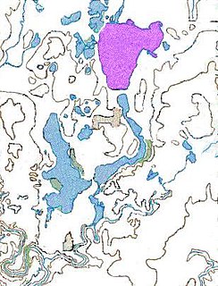
Gull Point State Park is a state park of Iowa, United States, located on West Okoboji Lake in the city of Wahpeton. It is the primary state park unit in the Iowa Great Lakes region. Two areas of the park were listed as nationally recognized historic districts on the National Register of Historic Places in 1990.

Lake Ahquabi State Park is a state park of Iowa, US, featuring a 115-acre (47 ha) reservoir. Ahquabi means "resting place" in the Fox language. The park is 6 miles (9.7 km) south of Indianola and 22 miles (35 km) south of Des Moines. Three section of the park were listed on the National Register of Historic Places in 1991.
Squirrel Hollow County Park is located along the North Raccoon River southeast of Jefferson, Iowa, United States. It was established in 1934, and it is the second oldest county park in the state of Iowa. The 60-acre (24 ha) park is bordered on two sides by a 147-acre (59 ha) wildlife management area. Both are managed by the Greene County Conservation Board. They are open from April 1 to November 1 and feature facilities for camping, fishing, canoeing, kayaking, hiking, picnicking, and equestrian camping and trails. The park was listed as a historic district on the National Register of Historic Places in 1991.
Beeds Lake State Park is located northwest of Hampton, Iowa, United States. It was listed has a historic district on the National Register of Historic Places as Beeds Lake State Park, Civilian Conservation Corps Area in 1990. At the time of its nomination it contained 21 resources, which included one contributing building, 15 contributing structures, and five non-contributing structures. The 319-acre (129 ha) park surrounds a 99-acre (40 ha) reservoir. It features hiking trails, boating, fishing, swimming, camping, picnic areas and shelters, lodges and concessions.

Pilot Knob State Park is located southeast of Forest City, Iowa, United States. Founded in 1923, it is one of the oldest state parks in Iowa. Between 1990 and 1995 one area was named nationally recognized historic district and five structures were individually listed on the National Register of Historic Places.

Lacey-Keosauqua State Park is located southwest of Keosauqua, Iowa, United States. Located along the Des Moines River in Van Buren County, it was dedicated in 1921. It is the largest state park in size in Iowa. In 1990 three areas were named nationally recognized historic districts and listed on the National Register of Historic Places.
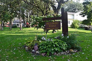
Pillsbury Point State Park is located in Arnolds Park, Iowa, United States. It is Iowa's smallest state park and unlike the others, it is an urban park. At 6.48 acres (2.62 ha), it is a narrow park that extends along a point of land into West Okoboji Lake adjacent to private summer houses. The overlook at the north end of the park was listed on the National Register of Historic Places in 1990. The historic designation includes walkways along the lake, stone steps, stone benches, and property boundary markers.
Pikes Point State Park is located southwest of Spirit Lake, Iowa, United States. It is a small park on a point of land that projects into West Okoboji Lake. It provides space for picnicking, including a shelter listed on the National Register of Historic Places, a playground, a swimming beach, boating and fishing on the lake.
Trapper's Bay State Park is located on the west side of Lake Park, Iowa, United States. The 57.5-acre (23.3 ha) park is along the north shore of Silver Lake. It provides space for picnicking, including a shelter listed on the National Register of Historic Places, and boating and fishing on the lake.

Wapsipinicon State Park is located south of Anamosa, Iowa, United States. The 394-acre (159 ha) park is along the sandstone and limestone bluffs of the Wapsipinicon River, from which it derives its name. It is one of the oldest state parks in Iowa, and it was listed as a historic district on the National Register of Historic Places in 2014.