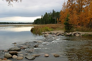
Itasca State Park is a state park of Minnesota, United States, and contains the headwaters of the Mississippi River. The park spans 32,690 acres (132.3 km2) of northern Minnesota, and is located about 21 miles (34 km) north of Park Rapids, Minnesota and 25 miles (40 km) from Bagley, Minnesota. The park is part of Minnesota's Pine Moraines and Outwash Plains Ecological Subsection and is contained within Clearwater, Hubbard, and Becker counties.

Ricketts Glen State Park is a Pennsylvania state park on 13,193 acres (5,280 ha) in Columbia, Luzerne, and Sullivan counties in Pennsylvania in the United States. Ricketts Glen is a National Natural Landmark known for its old-growth forest and 24 named waterfalls along Kitchen Creek, which flows down the Allegheny Front escarpment from the Allegheny Plateau to the Ridge-and-Valley Appalachians. The park is near the borough of Benton on Pennsylvania Route 118 and Pennsylvania Route 487, and is in five townships: Sugarloaf in Columbia County, Fairmount and Ross in Luzerne County, and Colley and Davidson in Sullivan County.

Worlds End State Park is a 780-acre (316 ha) Pennsylvania state park in Sullivan County, Pennsylvania. The park, nearly surrounded by Loyalsock State Forest, is in the Loyalsock Creek valley on Pennsylvania Route 154 in Forks and Shrewsbury Townships southeast of the borough of Forksville. The name Worlds End has been used since at least 1872, but its origins are uncertain. Although it was founded as Worlds End State Forest Park by Governor Gifford Pinchot in 1932, the park was officially known as Whirls End State Forest Park from 1936 to 1943.
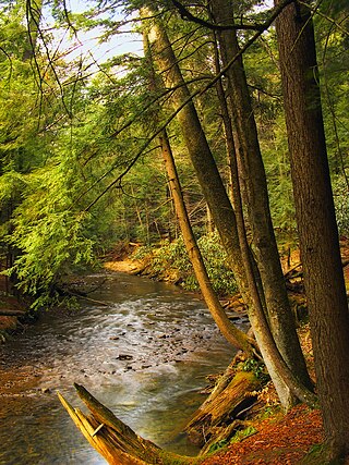
Cook Forest State Park is a 8,500-acre (3,440 ha) Pennsylvania state park in Farmington Township, Clarion County, Barnett Township, Forest County and Barnett Township, Jefferson County, Pennsylvania in the United States. Located just south of the Allegheny National Forest, the park is a heavily wooded area of rolling hills and mountains along the Clarion River in northwestern Pennsylvania. Cook Forest State Park is known for some of America's finest virgin white pine and hemlock timber stands and was once called the "Black Forest" due to the preponderance of evergreen tree coverage.

Lake Shetek State Park is a state park of Minnesota, United States, on Lake Shetek, which is the largest lake in southwestern Minnesota and the headwaters of the Des Moines River. It is most popular for water recreation and camping. However the park also contains historical resources related to the Dakota War of 1862, including an original log cabin and a monument to 15 white settlers killed there and at nearby Slaughter Slough on August 20, 1862.
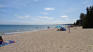
Harrisville State Park is a public recreation area covering 107 acres (43 ha) on the shore of Lake Huron off U.S. Route 23 in Harrisville and Harrisville Township, Alcona County, Michigan. The state park contains more than 100 acres of heavily forested land as well as a mile-long sandy beach. It is considered an important location for birders, with large and varied migratory populations of warblers and other song birds. The park is administered by the Michigan Department of Natural Resources.

Black Moshannon State Park is a 3,480-acre (1,410 ha) Pennsylvania state park in Rush Township, Centre County, Pennsylvania, United States. It surrounds Black Moshannon Lake, formed by a dam on Black Moshannon Creek, which has given its name to the lake and park. The park is just west of the Allegheny Front, 9 miles (14 km) east of Philipsburg on Pennsylvania Route 504, and is largely surrounded by Moshannon State Forest. A bog in the park provides a habitat for diverse wildlife not common in other areas of the state, such as carnivorous plants, orchids, and species normally found farther north. As home to the "largest reconstituted bog in Pennsylvania", it was chosen by the Pennsylvania Department of Conservation and Natural Resources for its "25 Must-see Pennsylvania State Parks" list.

Swatara State Park is a 3,515-acre (1,422 ha) Pennsylvania state park in Bethel, Swatara and Union Townships, Lebanon and Pine Grove Township, Schuylkill Counties in Pennsylvania in the United States. 8 miles (13 km) of Swatara Creek lie within the park's boundaries, which are roughly formed by Pennsylvania Route 443 to the north and Interstate 81 to the south. The park is in a valley in the ridge and valley region of Pennsylvania between Second Mountain (north) and Blue Mountain (south).

Sinnemahoning State Park is a 1,910-acre (773 ha) Pennsylvania state park in Grove Township, Cameron County and Wharton Township, Potter County, Pennsylvania, in the United States. The park is surrounded by Elk State Forest and is mountainous with deep valleys. The park is home to the rarely seen elk and bald eagle. Sinnemahoning State Park is on Pennsylvania Route 872, eight miles (13 km) north of the village of Sinnamahoning. In 1958, the park opened under the direction of the Pennsylvania Bureau of Forestry: it became a Pennsylvania State Park in 1962.

R. B. Winter State Park is a Pennsylvania state park on 695 acres (281 ha) in Hartley Township, Union County, Pennsylvania in the United States. It is in the ridge and valley region of Pennsylvania and is surrounded by Bald Eagle State Forest. R. B. Winter State Park is in a shallow basin that is surrounded by ridges. Halfway Lake is the central recreational focus of the park. The park is 18 miles (29 km) west of Lewisburg on Pennsylvania Route 192.

White Pines Forest State Park, more commonly referred to as White Pines State Park, is an Illinois state park in Ogle County, Illinois. It is located near the communities of Polo, Mount Morris and Oregon. The 385-acre (156 ha) park contains the southernmost remaining stand of native white pine trees in the state of Illinois, and that area, 43 acres (17 ha), was designated an Illinois Nature Preserve in 2001.

Kooser State Park is a 250-acre (101 ha) Pennsylvania state park in Jefferson Township, Somerset County, Pennsylvania, in the United States. The park, which borders Forbes State Forest, was built in the 1930s by the Civilian Conservation Corps, who also built the 4-acre (1.6 ha) Kooser Lake by damming Kooser Run. Kooser State Park is on Pennsylvania Route 31 a one-hour drive from Pittsburgh. The park is surrounded by Forbes State Forest.

Linn Run State Park is a Pennsylvania state park on 612 acres (248 ha) in Cook and Ligonier Townships, Westmoreland County, Pennsylvania in the United States. The park borders Forbes State Forest. Two smaller streams, Grove Run and Rock Run, join in Linn Run State Park to form Linn Run which has a waterfall, Adams Falls, which can be seen at the park. This state park is just off Pennsylvania Route 381 near the small town of Rector.

Backbone State Park is Iowa's oldest state park, dedicated in 1919. Located in the valley of the Maquoketa River, it is approximately three miles (5 km) south of Strawberry Point in Delaware County. It is named for a narrow and steep ridge of bedrock carved by a loop of the Maquoketa River originally known as the Devil's Backbone. The initial 1,200 acres (490 ha) were donated by E.M. Carr of Lamont, Iowa. Backbone Lake Dam, a relatively low dam built by the Civilian Conservation Corps (CCC) in the 1930s, created Backbone Lake. The CCC constructed a majority of trails and buildings which make up the park.

Westmoreland State Park lies within Westmoreland County, Virginia. The park extends about one and a half miles along the Potomac River and covers 1,321 acres. The Horsehead Cliffs provide visitors with a panoramic view of the Potomac River, and lower levels feature fossils and beach access. The park offers hiking, camping, cabins, fishing, boating and swimming, although mechanical issues have kept the swimming pool closed since 2021. Located on the Northern Neck Peninsula, the park is close to historical sites featuring earlier eras: George Washington's birthplace and Stratford Hall, the birthplace of Robert E. Lee.
Conococheague Mountain is a long and narrow mountain located in the far western corner of Perry County, Pennsylvania. The highest point on the mountain is a summit known as Round Top; it rises to an elevation of 2,190 feet (670 m) and is located at the very southern end of the ridge. The mountain is almost entirely located in the Tuscarora State Forest, and has numerous hiking trails and dirt roads, including Bryner Road, New Germantown Road, and the Iron Horse Trail. The nearest town to the mountain is Blain.

Nine Eagles State Park is a 1,100-acre (450 ha) state park in Decatur County, Iowa, United States, near the city of Davis City. The park is located within a hilly area of the state and includes a 64-acre (26 ha) lake.
Lake Macbride State Park is a 2,180-acre (880 ha) state park in Johnson County, Iowa, United States, located near the city of Solon. The park is composed of two units centered on the 900-acre (360 ha) Lake Macbride. Both the park and the lake are named for Iowa conservationist Thomas Huston Macbride.

Palisades-Kepler State Park is a 840-acre (340 ha) state park in Linn County, Iowa, United States, near the city of Mount Vernon. The park is located in a forested area on the bank of the Cedar River marked by bluffs and ravines. While the state created the park in 1922, it was greatly expanded in 1928 through the estate of Louis H. Kepler and further developed in the 1930s by the Civilian Conservation Corps (CCC).
Union Grove State Park is a 282-acre (114 ha) state park in Tama County, Iowa, United States, near the city of Gladbrook. The park, which was opened in 1938, is home to the 110-acre (45 ha) Union Grove Lake along with a dam and a waterfall.
