Bewabic State Park is a public recreation area covering 315 acres (127 ha) on the shore of Fortune Lake, four miles (6.4 km) west of Crystal Falls in Iron County, Michigan. The state park's rich Civilian Conservation Corps history is evidenced by the CCC structures still in use. The park was listed on the National Register of Historic Places for its CCC-related architecture in 2016.

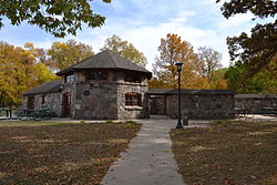
Montauk State Park is a public recreation area occupying nearly 3,000 acres (1,200 ha) at the headwaters of the Current River, fifteen miles (24 km) southwest of Salem, Missouri. The state park contains a fish hatchery and is noted for its rainbow and brown trout angling. It was acquired in 1926. The park has several natural springs including Montauk Spring with a daily average flow of 53 million gallons of water.

Black Moshannon State Park is a 3,480-acre (1,410 ha) Pennsylvania state park in Rush Township, Centre County, Pennsylvania, United States. It surrounds Black Moshannon Lake, formed by a dam on Black Moshannon Creek, which has given its name to the lake and park. The park is just west of the Allegheny Front, 9 miles (14 km) east of Philipsburg on Pennsylvania Route 504, and is largely surrounded by Moshannon State Forest. A bog in the park provides a habitat for diverse wildlife not common in other areas of the state, such as carnivorous plants, orchids, and species normally found farther north. As home to the "largest reconstituted bog in Pennsylvania", it was chosen by the Pennsylvania Department of Conservation and Natural Resources for its "25 Must-see Pennsylvania State Parks" list.

Whipple Dam State Park is a Pennsylvania state park on 256 acres (104 ha) in Jackson Township, Huntingdon County, Pennsylvania in the United States. Whipple Lake is a man-made lake on 22 acres (8.9 ha) that was originally built during the height of the lumber era that swept through Pennsylvania in the late 19th and early 20th century to supply power for a sawmill. Whipple Dam State Park is 12 miles (19 km) south of State College, just east of Pennsylvania Route 26.

Lake Keomah State Park is a state park of Iowa, USA. It is in Mahaska County. To the park's immediate east is Keomah Village and the park is approximately 4 miles (6.4 km) east of Oskaloosa.

Table Rock State Park is a 3,083-acre (12.48 km2) park at the edge of the Blue Ridge Mountains in northern Pickens County, South Carolina. The park includes Pinnacle Mountain, the tallest mountain totally within the state.

Backbone State Park is Iowa's oldest state park, dedicated in 1919. Located in the valley of the Maquoketa River, it is approximately three miles (5 km) south of Strawberry Point in Delaware County. It is named for a narrow and steep ridge of bedrock carved by a loop of the Maquoketa River originally known as the Devil's Backbone. The initial 1,200 acres (490 ha) were donated by E.M. Carr of Lamont, Iowa. Backbone Lake Dam, a relatively low dam built by the Civilian Conservation Corps (CCC) in the 1930s, created Backbone Lake. The CCC constructed a majority of trails and buildings which make up the park.

Crystal Lake State Park is a day-use state park and historic site in Barton, Vermont, United States. It is located at 96 Bellwater Avenue, off Willoughby Lake Road just east of the village, at the northwestern end of 763-acre (309 ha) Crystal Lake. It features a sandy beach with swimming area, and a bath house built by the Civilian Conservation Corps (CCC). A cottage is available for rental. The park was added to the U.S. National Register of Historic Places on August 30, 2005, for its association with the CCC.

Huntsville State Park is a 2,083.2-acre (843 ha) wooded recreational area, six miles (10 km) southwest of Huntsville, Texas, within Walker County and the Sam Houston National Forest.

Black Hawk State Park is a state park of Iowa, USA, in the town of Lake View. The park includes land, campgrounds, trails, game preserves, historic structures, and the waters of Black Hawk Lake. Also it is home to the Lake View Water Carnival. This event is held the third full weekend in July every year, and includes many family-friendly activities including a Water Parade. Three sections of the park were listed on the National Register of Historic Places in 1991.

The Black Moshannon State Park Historic Districts are three separate historic districts on the National Register of Historic Places (NRHP) at Black Moshannon State Park in Rush Township, Centre County, Pennsylvania in the United States. The structures in the historic districts were constructed in the 1930s during the Great Depression by the Civilian Conservation Corps (CCC). The three districts are: the Beach and Day Use District, with 18 contributing structures, including 11 different picnic pavilions, concession building, bathhouse, museum, and four open pit latrines; the Family Cabin District with 16 contributing properties, including 13 cabins, one lodge and two latrines; and the Maintenance District with four contributing properties, including a storage building, three-bay garage, gas pump house, and ranger's residence.

Copper Falls State Park is a 3,068-acre (1,242 ha) state park in Wisconsin. The park contains a section of the Bad River and its tributary the Tylers Forks, which flow through a gorge and drop over several waterfalls. Old Copper Culture Indians and later European settlers mined copper in the area. The state park was created in 1929 and amenities were developed by the Civilian Conservation Corps and the Works Progress Administration. In 2005 the park was listed on the National Register of Historic Places as a site with 10 contributing properties.
Roaring River State Park is a public recreation area covering of 4,294 acres (1,738 ha) eight miles (13 km) south of Cassville in Barry County, Missouri. The state park offers trout fishing on the Roaring River, hiking on seven different trails, and the seasonally open Ozark Chinquapin Nature Center.

Okmulgee Park is a city park in Okmulgee, Oklahoma in the United States. The park contains 1,075 acres (435 ha) and sits at an elevation of 758 feet (231 m). The park is adjacent to Dripping Springs Park and is located on Okmulgee Lake. Okmulgee Park, a municipal park established in 1963, is open for year-round recreation including camping, fishing, swimming and hiking.

Oak Lodge is a historic recreational building, located on the west side of Schreeder Pond in Chatfield Hollow State Park in Killingworth, Connecticut. Built in 1937, it is one of Connecticut's finest examples of construction by crews of the Civilian Conservation Corps (CCC). It, along with Schreeder Pond and other CCC-built park features, was listed on the National Register of Historic Places in 1986.

Lake Ahquabi State Park is a state park of Iowa, US, featuring a 115-acre (47 ha) reservoir. Ahquabi means "resting place" in the Fox language. The park is 6 miles (9.7 km) south of Indianola and 22 miles (35 km) south of Des Moines. Three sections of the park were listed on the National Register of Historic Places in 1991.

Hopeville Pond State Park is a public recreation area located on Hopeville Pond, an impoundment of the Pachaug River, in the town of Griswold, Connecticut. A portion of the 554-acre (224 ha) state park occupies the site of the lost village of Hopeville. The park manager's house occupies Avery House, which is listed on the National Register of Historic Places. The park offers fishing, swimming, camping, and trails for hiking and biking. It is managed by the Connecticut Department of Energy and Environmental Protection.

Ratcliff Lake Recreation Area is a developed park within the Davy Crockett National Forest near Kennard, Texas, United States. The park surrounds a 45-acre (18 ha) lake that was once a mill pond and source of water for a sawmill which operated from 1902 to 1920. Ratcliff Lake Recreation Area was built in 1936 by the Civilian Conservation Corps (CCC) and is operated by the United States Forest Service (USFS). The facility is open year-round and includes a large campground, picnic areas, an amphitheater, a swim area and hiking trails.

Lacey-Keosauqua State Park is located southwest of Keosauqua, Iowa, United States. The park is located along the Des Moines River in Van Buren County. First dedicated in 1921, it is the largest state park in size in Iowa. In 1990, three areas were named nationally recognized historic districts and listed on the National Register of Historic Places.
Sand Bar State Park is a 15-acre (6.1 ha) state park in Milton, Vermont on the shore of Lake Champlain. The park was established in 1933.