
Deep Creek Lake is a man-made reservoir in the U.S. state of Maryland. It has an area of 3,900 acres (16 km2), a shoreline length of 69 miles (111 km), and a volume of 106,000 acre⋅ft (0.131 km3). The lake is home to a wide variety of aquatic life, such as freshwater fish and aquatic birds. Along with the nearby Wisp Ski Resort, the lake is a popular regional vacation and tourism destination.
Okamanpeedan Lake, partially located in Martin County, Minnesota, and Emmet County, Iowa, is also known as Tuttle Lake. Okamanpeedan Lake is a roughly 2,300-acre (9.3 km2) riverine lake located on the East Fork of the Des Moines River. It has an average depth of about four to six feet. The lake has a contributing watershed of approximately 120,056 acres (486 km2) and watershed:lake ratio on the order of about 50:1. The lake is situated in a glacial till plain and is generally in an area dominated by loamy, poorly drained soils. The area is primarily level but does have some rolling hills.
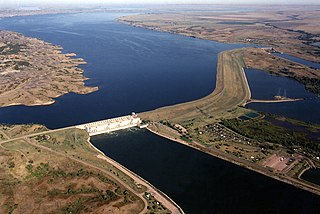
Lake Sharpe is a large reservoir impounded by Big Bend Dam on the Missouri River in central South Dakota, United States. The lake has an area of 56,884 acres (230.20 km2) and a maximum depth of 78 ft (24 m). Lake Sharpe is approximately 80 mi (130 km) long, with a shoreline of 200 mi (320 km). Lake Sharpe is the 54th largest reservoir in the United States. The lake starts near Ft. Thompson and stretches upstream to Oahe Dam, near Pierre. The lake is located within the following counties: Buffalo, Lyman, Hyde, Hughes, and Stanley. The Big Bend of the Missouri is about 7 miles (11 km) north of the dam.
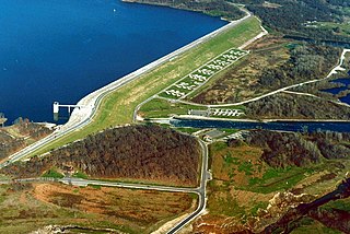
Saylorville Lake is a reservoir on the Des Moines River in Iowa, United States. It is located 11 miles (18 km) upstream from the city of Des Moines, and 214 miles (344 km) from the mouth of the Des Moines River at the Mississippi River. It was constructed as part of a flood control system for the Des Moines River as well as to aid in controlling flood crests on the Mississippi, of which the Des Moines is a tributary. The lake and dam is owned and operated by the U.S. Army Corps of Engineers, Rock Island District.

Clear Lake is the name of a natural spring fed body of water located in Cerro Gordo County, Iowa, near Clear Lake, Iowa. It is approximately 3,684 acres (15 km2) in size. It is a popular fishing destination, with walleye, yellow bass and channel catfish. People from Des Moines and Minneapolis–Saint Paul have had homes on the shores of the lake since the 1870s. The average depth is 10 feet (3 m) and the maximum depth is 30 feet (9 m), in the dredged area of the west end. The lake has 13.6 mi (22 km) of shoreline. As of 2004, the lake has seen major efforts undergone to restore its natural clarity, including filtration systems, dredging, and education of local farmers to reduce toxic pesticides from entering the lake. Clear Lake has been named the "Best Iowa Lake Town" by The Des Moines Register and "A Top Vacation Spot" by Midwest Living magazine.

Marsh Creek State Park is a 1,705 acres (690 ha) Pennsylvania state park in Upper Uwchlan and Wallace Townships, Chester County, Pennsylvania in the United States. The park is the location of the 535-acre (217 ha) man-made Marsh Creek Lake. With an average depth of 40 feet, the lake is stocked with fish and is a stop for migrating waterfowl. Marsh Creek State Park is 2 miles (3.2 km) west of Eagle on Pennsylvania Route 100. Park road hours 8:00 am until sunset. All other access open 24 hours.

Rock Creek State Park is a state park in Jasper County, Iowa, United States, located near the city of Kellogg.
McGee Creek State Park is a state park in southern Oklahoma. The park is on the south side of McGee Creek Reservoir, which impounds the waters of McGee Creek. Created in 1985 the reservoir provides flood control. The park is approximately 2,600 acres (1,100 ha) and the reservoir is approximately 3,800 acres (1,500 ha). Its main staple is recreational and sport fishing. The main fish fished for in this park include Crappie, Sunfish, Largemouth bass, and Channel catfish. The McGee Creek Wildlife Management area is located between the two arms of the reservoir.

Pleasant Creek Wildlife Management Area is located near Philippi, West Virginia in Barbour and Taylor counties. Located on 3,030 acres (1,230 ha) land that varies from wetlands to steeply forested woodlands, the Pleasant Creek WMA rises to an elevation of 1,600 feet (490 m).
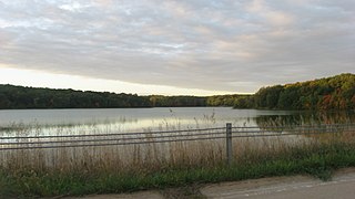
Geode State Park is a state park in Henry County, Iowa bordering Des Moines County. It is managed by the Iowa Department of Natural Resources. While it is named for Iowa's state rock, the geode, few can be found in the park. A display of geodes, with their mysterious crystal formations in their hollow cavities, can be seen at the park office. It is illegal to remove geodes from state parks.

Lake Sugema [Pronounced sōō•jē’•mə](+40° 41' 22.85", -91° 59' 39.01") is a man-made 574-acre (2.32 km2) lake 3 miles (4.8 km) southwest of Keosauqua, Van Buren County, in southeast Iowa, United States. It is located south of the Des Moines River, west of State Highway 1 and north of State Highway 2.

High Trestle Trail is a rail trail running from Ankeny to Woodward in central Iowa. The recreation trail opened on April 30, 2011. It is a paved recreational trail that runs through the Polk, Story, Boone, and Dallas counties. The trail's name is derived from a former 1913 bridge that spanned the Des Moines River between the towns of Madrid and Woodward.
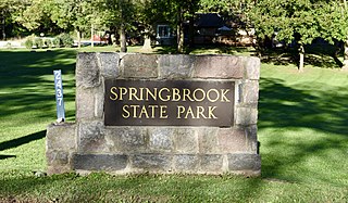
Springbrook State Park is a state park in Guthrie County, Iowa, United States, located approximately 5 miles (8.0 km) west of the city of Yale. The park contains a 17-acre (6.9 ha) spring-fed lake and timber-covered rolling hills along the Middle Raccoon River.

Lake Ahquabi State Park is a state park in Warren County, Iowa, United States, featuring a 115-acre (47 ha) reservoir. Ahquabi means "resting place" in the Fox language. The park is 6 miles (9.7 km) south of Indianola and 22 miles (35 km) south of Des Moines. Three sections of the park were listed on the National Register of Historic Places in 1991.

Lake Chatuge is a man-made reservoir in Towns County, Georgia, and Clay County, North Carolina. It was formed by the Tennessee Valley Authority's construction of Chatuge Dam in 1942. The lake is relatively shallow with depths of 30 feet (9.1 m) and reaches 144 feet (44 m) by the dam. In an average year the water level varies 10 feet (3.0 m) from winter to summer to provide seasonal flood storage. Lake Chatuge is the highest major lake in the state of Georgia. It takes up 7,000 acres and is 13 miles (21 km) long.
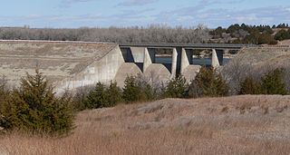
Medicine Creek Dam is a dam in Frontier County, Nebraska.
Cuba Lake is a 454-acre (1.84 km2) reservoir in Allegany and Cattaraugus counties, New York.
Big Creek Lake is a lake situated in the Big Creek State Park in Polk County, Iowa. The lake is situated two miles to the north of Polk City, spreads across 814 acres (329 ha), and its mean depth is 17.3 feet (5.3 m). The lake's purpose was to protect Polk City from floods. It was a part of the Saylorville project. It provides numerous recreational options including fishing, picnicking, swimming, boating, camping, and others.
Seneca Creek, also known as Cienequilla Creek, is a watercourse in New Mexico and Oklahoma. Running south of, and roughly parallel to, Corrumpa Creek, it originates south-southeast of Des Moines, New Mexico and east-northeast of Grenville, and travels generally east, eventually crossing into Oklahoma. Where it finally joins Corrumpa Creek about 4.5 miles northwest of Felt, Oklahoma, the combined stream becomes the Beaver River.
Badger Creek State Recreation Area is a state recreation area in Madison County, Iowa, United States, near the city of Van Meter. The park covers over 700 acres (280 ha) of land and includes the 276-acre (112 ha) Badger Creek Lake. The lake has two boat ramps and multiple fishing jetties; fish living in the lake include bass, bluegill, catfish, and crappie. The entire recreation area is also open for hunting.


