Eva Site

Last updated
Eva Site
(6 BN 12)
Eva-monument-tn1.jpg
Eva Monument at Eva Beach
USA Tennessee location map.svg
Archaeological site icon (red).svg
Location within Tennessee today
Location Benton County, Tennessee, Flag of the United States.svg  USA
Region Benton County, Tennessee
Coordinates 36°4′29.17″N87°58′59.34″W / 36.0747694°N 87.9831500°W / 36.0747694; -87.9831500
History
Cultures Archaic period
Site notes
Excavation dates1940

The Eva site (40BN12) is a prehistoric Native American site in Benton County, Tennessee, in the Southeastern United States. Located along an ancient channel of the Tennessee River, the Eva site saw extensive periods of occupation during the Middle and Late Archaic period (c. 6000-1000 BC). The site's well-defined midden layers helped investigators identify three distinct Archaic cultures, the oldest of which was first identified at Eva and is still known as the "Eva culture" or the "Eva phase."

Contents

The Eva site is now submerged by Kentucky Lake, an artificial reservoir created by the impoundment of the Tennessee River by Kentucky Dam. In 1940, before the Tennessee River was dammed to form Kentucky Lake, University of Tennessee archaeologists conducted excavations at the Eva site and managed to extract a relatively large amount of data. The data and artifacts were analyzed by University of Tennessee anthropologists Thomas Lewis and Madeline Kneburg Lewis, who presented their findings in a 1961 publication entitled Eva, an Archaic Site.

Geographical setting

Diagram showing a rough pre-inundation profile of the floodplain upon which the Eva site was located. Approximately one mile separated the site from the Tennessee River. Eva-archaic-site-profile-tn1.jpg
Diagram showing a rough pre-inundation profile of the floodplain upon which the Eva site was located. Approximately one mile separated the site from the Tennessee River.

The Tennessee River enters the Benton County area from the south and proceeds northward for nearly 100 miles (160 km) before emptying into the Ohio River. Kentucky Dam, located nearly 80 miles (130 km) downstream from the Eva site, was completed in 1944 and created a lake that spans most of the state from north-to-south. Hills that comprise the western fringe of the Highland Rim rise as high as 300 feet (91 m) above the river to the east and west. The Eva site is named for the community of Eva, which is centered approximately 2 miles (3.2 km) to the southwest.

Before inundation by Kentucky Lake, the Eva site was located on a flood plain that stretched for nearly 2 miles (3.2 km) between the river bank and the hills to the west. This floodplain was characterized by a series of swells (natural levees created by river deposits) and swales (ancient river channels and tributary channels). The Eva site was situated on a high swell between a swale known as Three Mile Slough to the east and a swale known as the Cypress Creek Slough to the west. In Archaic times, the Tennessee River proper flowed through Three Mile Slough (roughly a mile west of its modern pre-inundation channel). As Three Mile Slough joins Cypress Creek immediately north of the Eva site, it's likely the site was situated at the ancient confluence of Cypress Creek and the Tennessee River. [1]

Kentucky Lake is managed by the Tennessee Valley Authority. Much of the current lakeshore above the Eva site is part of Nathan Bedford Forrest State Park. The submerged Eva site is visible from atop Pilot Knob to the north and from the Eva Beach boat ramp to the south. In 1993, the Benton County Genealogical Society erected a small monument at Eva Beach recalling the Eva site's Archaic-era importance.

Archaeological findings

The Eva site, looking north from Eva Beach Eva-site-from-eva-beach-tn1.jpg
The Eva site, looking north from Eva Beach

The University of Tennessee and the Works Progress Administration conducted excavations at the Eva site from September 11, 1940 through November 23, 1940. [2] Excavators identified six soil layers, the uppermost being the plowzone and the others labeled Strata I-V, with Stratum V being the deepest. The plowzone and Stratum I contained artifacts that were predominantly associated with a Late Archaic people known as the Big Sandy culture, who occupied the Eva site roughly 2000-1000 BC (and possibly as late as 500 BC). Stratum II contained artifacts associated with a Middle Archaic people known as the Three Mile culture, who occupied Eva around 4000-2000 BC. Stratum III contained only scant cultural material, indicating that the Eva site was unoccupied for a period around 4000 BC. Stratum IV and Stratum V contained material associated with a culture first identified at Eva and thus referred to as the Eva culture. The Eva culture was operating at the Eva site by 5200 BC and probably occupied the site as early as 6000 BC. [3]

Flint and chert artifacts uncovered at Eva included projectile points, blades, and butchering tools. [4] Stone artifacts included atlatl weights, gorgets, and pestles. [5] Bone artifacts included awls, needles, fishhooks, and a necklace composed of snake vertebrae. [6] Antler artifacts included scrapers, projectile points, and atlatl hooks. [7]

180 human burials were uncovered at the Eva site. These burials included 29 infants, 11 children, 7 juveniles, and 133 adults. Most of the adults were younger than 45 years old, although a few lived well into their 70s. Pathological analyses conducted on the site's human remains indicates that Eva's Archaic inhabitants were healthy compared to the region's later cultures. [8] Along with the human burials, 18 dog burials were uncovered at the Eva site. [9]

The Eva site's inhabitants

While Clovis points and other Paleo-Indian artifacts have been found along the Tennessee River in Benton County, [10] [11] major occupation of the site didn't begin until around 6000 BC during the Middle Archaic period. Substantial occupation continued at Eva until at least 1000 BC and possibly as late as 500 BC. While pottery sherds dating to the Woodland period and Mississippian period were uncovered at Eva, they were relatively scant. [12] The Eva site was uninhabited when Euro-American explorers and settlers arrived in the late 18th century, although the junction of two major Native American trails ("traces") occurred just south of the site. [13]

Cultural materials and features uncovered from Stratum IV and Stratum V (which correlate to the Eva culture) include mussel shells, fire-cracked rocks, flint chips, antler tools, projectile points, and animal bones (mostly deer). Using radiocarbon testing, an antler section uncovered from Stratum IV was dated to roughly 5200 BC. A pile of chert projectile point blanks and the relatively large number of tools might indicate the location of a workshop. [14]

Very little cultural material was uncovered from Stratum III, indicating a significant gap between the Eva occupation and the Three Mile occupation. Materials and features uncovered in Stratum II (which correlates to the site's Three Mile phase) include fire-cracked rocks, mussel shells and a curious mussel shell arrangement, ash content, and animal bones. While deer bones still comprised the majority of the animal bones, the percentage was significantly lower than that of the Eva phase, indicating a greater reliance upon fish and bird meat. [15]

Cultural materials uncovered from Stratum I and the plowzone (which correlate to the site's Big Sandy phase) include burned clay, a hearth, a mortar, hammerstones, and bone needles. Deer still comprised the greatest percentage of animal bones, but, as with the site's Three Mile phase, birds and fish were providing major supplements. Unlike previous phases, however, very few mussel shells were uncovered in Stratum I. Lewis and Lewis hypothesized that the lack of mussel shells indicates higher river levels in the Late Archaic period. [16]

Sources

Related Research Articles

Nathan Bedford Forrest State Park

Nathan Bedford Forrest State Park is a state park in Benton County, Tennessee, in the southeastern United States. The park is situated on the western shore of the Kentucky Lake impoundment of the Tennessee River, just north of the community of Eva. Established in 1929, the park consists of 2,587 acres (10.47 km2) managed by the Tennessee Department of Environment and Conservation.

The Maple Creek Phase is an archaeological phase, remains of which have been found on the Ohio and Kentucky sides of the Ohio River, primarily around the area of modern Cincinnati. The material culture of the Maple Creek phase is characterized by McWhinney Heavy Stemmed points, Meron-Trimble points, a chipped-stone micro-tool industry, diagnostic features such as earth ovens, and large riverine base camps. This suite of cultural characteristics appear to be shared by a number of sites in this area in the period of approximately 5000-3000 B.P., ending with the Early Woodland period.

Eva, Tennessee Census-designated place in Tennessee, United States

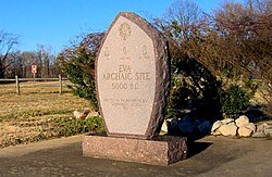
Eva is an unincorporated community and census-designated place (CDP) in Benton County, Tennessee, United States, on the western shore of the Kentucky Lake impoundment of the Tennessee River. It is the site of Nathan Bedford Forrest State Park. As of the 2010 census, its population was 293. The ZIP Code Tabulation Area for the ZIP code (38333) that serves Eva had a population of 574 as of the 2000 U.S. Census, when Eva was not yet a CDP. Eva is centered on the junction of State Route 191, which connects the community to Nathan Bedford Forrest State Park to the north and the town of Camden to the south, and Eva Beach Road, which stretches from the center of the community to its beach along Kentucky Lake.

Indian Knoll Archaeological site in Kentucky, US

Indian Knoll is an archaeological site near Paradise, Kentucky that was declared to be a U.S. National Historic Landmark.

Mialoquo (Cherokee town) United States historic place

Mialoquo is a prehistoric and historic Native American site in Monroe County, Tennessee, in the southeastern United States. The site saw significant periods of occupation during the Mississippian period and later as a Cherokee refugee village. While the archaeological site of Mialoquo was situated on the southwest bank of the Little Tennessee River, the village's habitation area probably included part of Rose Island, a large island in the river immediately opposite the site. Rose Island was occupied on at least a semi-permanent basis as early as the Middle Archaic period.

The Pisgah Phase is an archaeological phase of the South Appalachian Mississippian culture in the Appalachian Summit area of northeastern Tennessee, Western North Carolina and northwestern South Carolina.

The Buffalo Indian Village Site is an archaeological site located near Buffalo, Putnam County, West Virginia along the Kanawha River in the United States. This site sits atop a high terrace on the eastern bank of the Kanawha River and was once home to a variety of Native American villages including the Archaic, Middle Woodland and Fort Ancient cultures of this region. Buffalo Village was the site of one of the first systematic archaeological projects performed in West Virginia and it was added to the National Register of Historic Places in 1971.

Dust Cave is a Paleoindian archaeology site located in northern Alabama. It is in the Highland Rim in the limestone bluffs that overlook Coffee Slough, a tributary of the Tennessee River. The site was occupied during the Pleistocene and early Holocene eras. 1LU496, another name for Dust Cave, was occupied seasonally for 7,000 years. The cave was first discovered in 1984 by Dr. Richard Cobb and first excavated in 1989 under Dr. Boyce Driskell from the University of Alabama.

Franktown Cave United States historic place

Franktown Cave is located 25 miles south of Denver, Colorado on the north edge of the Palmer Divide. It is the largest rock shelter documented on the Palmer Divide, which contains artifacts from many prehistoric cultures. Prehistoric hunter-gatherers occupied Franktown Cave intermittently for 8000 years beginning about 6400 B.C. The site held remarkable lithic and ceramic artifacts, but it is better known for its perishable artifacts, including animal hides, wood, fiber and corn. Material goods were produced for their comfort, task-simplification and religious celebration. There is evidence of the site being a campsite or dwelling as recent as AD 1725.

Trinchera Cave Archeological District United States historic place

The Trinchera Cave Archeological District (5LA9555) is an archaeological site in Las Animas County, Colorado with artifacts primarily dating from 1000 BC to AD 1749, although there were some Archaic period artifacts found. The site was added to the National Register of Historic Places in 2001 and is located on State Trust Lands.

John Broster

John Bertram Broster is an American archaeologist formerly serving as the Prehistoric Archeological Supervisor at the Tennessee Division of Archaeology, Department of Environment and Conservation. He is best known for his work on the Paleoindian period of the American Southwest and Southeast, and has published some 38 book chapters and journal articles on the subject.

Carlston Annis Shell Mound United States historic place

The Carlston Annis Shell Mound is a prominent archaeological site in the western part of the U.S. state of Kentucky. Located along the Green River in Butler County, this shell midden has been declared a historic site because of its archaeological value.

The KYANG Site, also known as the Kentucky Air National Guard Site or 15JF267, is a prehistoric archaeological site located on the grounds of the Louisville Air National Guard Base in Louisville, Kentucky. The site was occupied from the Early Archaic period to the Late Woodland period. The site includes two zones, both of which contain extensive midden deposits. Burials were also conducted at the site, and human remains have been recovered from both zones. The site was discovered in 1972 during construction work at the base; formal excavations at the site began the following year.

Martin Site (Fosters Falls, Virginia) United States historic place

The Martin Site (44WY13) is a prehistoric Native American village site in Wythe County, Virginia, United States. It is located on the banks of the New River near the community of Fosters Falls. The site has clear evidence of occupation during the Late Woodland period, and offers evidence of older occupation. Finds at the site include pottery sherds, stone tools, ceramic and shell trade items, and grave sites.

The Quad Site is a series of Paleoindian sites and localities in Limestone County near Decatur, Alabama. It was first reported by Frank Soday in 1954, and later findings were also documented by James Cambron, David Hulse and Joe Wright and Cambron and Hulse. The Quad Locale can seldom be viewed at current lake levels, even during normal winter pool, due to extensive erosion, but is considered one of the most important and well known Paleoindian sites in the Southeastern United States.

Griesmer Site Archaeological site in Indiana, United States

The Griesmer site (La-3) is located on the Kankakee River in Lake County, Indiana, about a mile southeast of Schneider, in Northwestern Indiana. It is classified as a Prehistoric, multi-component site with Middle Woodland, Late Woodland and Upper Mississippian occupations. The deposits were not stratified, but observation of the types of artifacts present, together with radiocarbon dates, helped to define the sequence of occupations at the site.

Fifield Site Archaeological site in Indiana

The Fifield site (Pr-55) is located on Damon Run Creek in Porter County, northwestern Indiana. It is classified as a late Prehistoric, single-component Upper Mississippian Fisher village.

Anker Site Archaeological site in Illinois, United States

The Anker Site (11Ck-21) is located on the Little Calumet River near Chicago, Illinois. It is classified as a late Prehistoric site with Upper Mississippian Huber affiliation.

Fisher Mound Group Archaeological site in Illinois, United States

The Fisher Mound Group is a group of burial mounds with an associated village site located on the DesPlaines River near its convergence with the Kankakee River where they combine to form the Illinois River, in Will County, Illinois, about 60 miles southwest of Chicago. It is a multi-component stratified site representing several Prehistoric Upper Mississippian occupations as well as minor Late Woodland and Early Historic components.

Upper Iowa River Oneota Site Complex Archaeological site complex in Iowa, United States

The Upper Iowa River Oneota Site Complex is a series of 7 Iowa archaeological sites located within a few miles of each other in Allamakee County, Iowa, on or near the Upper Iowa River. They are all affiliated with the Late Prehistoric Upper Mississippian Oneota Orr Focus. In some cases there are early European trade goods present, indicating occupation continued into the Protohistoric or early Historic period.

References

  1. Lewis and Lewis 1961, p. 1-4.
  2. Lewis and Lewis 1961, p. v.
  3. Lewis and Lewis 1961, p. 9-17, 173.
  4. Lewis and Lewis 1961, p. 25.
  5. Lewis and Lewis 1961, p. 70.
  6. Lewis and Lewis 1961, p. 76, 88.
  7. Lewis and Lewis 1961, p. 92.
  8. Faulkner, Charles (2002). "Eva Site". Tennessee Encyclopedia of History and Culture . Retrieved 2009-07-29.
  9. Lewis and Lewis 1961, p. 102-103.
  10. Guthe, Alfred (Spring 1962). Tennessee Archaeologist18 (1): 53. ISSN   0040-3180.
  11. Guthe, Alfred (Spring 1965). Tennessee Archaeologist21 (1): 28-29. ISSN   0040-3180.
  12. Lewis and Lewis 1961, p. 5.
  13. Smith, Jonathan Kennon (1970). A History of Benton County, Tennessee, to 1900. Memphis: J Edge Co. pp. 4–6. OCLC   117712.
  14. Lewis and Lewis 1961, p. 13-17.
  15. Lewis and Lewis 1961, p. 9, 15, 17-20.
  16. Lewis and Lewis 1961, p. 9-15.