Coosa chiefdom

Last updated
Map of the Paramount Chiefdom/Kingdom of Coosa in March 1538 (right before the De Soto expedition), along with its internal chiefdoms and neighboring states. Paramountcy of Coosa.jpg
Map of the Paramount Chiefdom/Kingdom of Coosa in March 1538 (right before the De Soto expedition), along with its internal chiefdoms and neighboring states.

The Coosa chiefdom was a powerful Native American paramount chiefdom in what are now Gordon and Murray counties in Georgia, in the United States. [1] It was inhabited from about 1400 until about 1600, and dominated several smaller chiefdoms. [2] The total population of Coosa's area of influence, reaching into present-day Tennessee and Alabama, has been estimated at 50,000.

Contents

Hernando de Soto and his conquistadors visited Coosa on their expedition through the Southeast United States in 1539–1541, as did participants in Tristán de Luna's expedition in 1560, and Juan Pardo's 1566–1568 expedition. [3] The Europeans recorded descriptions and impressions of the various chiefdoms they visited, describing Coosa as a series of communities and fertile gardens containing much food, rather than a town or city. [4] [ failed verification ]

Coosa was also the name of one of the four mother towns of the Muscogee Creek confederacy. [5]

History

The protohistoric King site on the Coosa River, occupied during the mid to late 1500s King Site Aerial HRoe 2018.jpg
The protohistoric King site on the Coosa River, occupied during the mid to late 1500s
Coosa Historical Marker along Coosa River, outside Childersburg, Alabama Coosa Historical Marker outside of Childersburg, AL.jpg
Coosa Historical Marker along Coosa River, outside Childersburg, Alabama
A map showing the de Soto expedition route through Georgia, South Carolina, North Carolina, Tennessee, and Alabama. Based on the Charles M. Hudson map of 1997 DeSoto Map Leg 2 HRoe 2008.jpg
A map showing the de Soto expedition route through Georgia, South Carolina, North Carolina, Tennessee, and Alabama. Based on the Charles M. Hudson map of 1997

The Coosa chiefdom was centered at a site along the Coosawattee River in present-day Gordon and Murray counties in northwestern Georgia. The capital of Coosa, it had a large plaza and three platform mounds, as well as residential dwellings. Researchers have found various Mississippian culture pottery types, the most substantial of which reflect the site's Middle and Late South Appalachian Mississippian culture (a regional variation of the Mississippian culture) habitation from 1300 to 1600. [1]

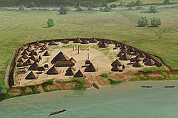
Archeologists, who nicknamed this settlement as "Little Egypt", have defined these as the Dallas, Lamar, and Mouse Creek phases of pottery. These type variations could indicate that the chiefdom underwent three archaeological phases and changes in culture, each with distinct pottery and artifact styles. Only one other village had a mound; the others associated with the chiefdom had only residential dwellings.

Hernando de Soto and his expedition entered the Coosa chiefdom in 1540. Chroniclers recorded that the chiefdom consisted of eight villages. Archaeologists have identified the remains of seven of these, including the capital. The population of the Coosa is thought to have been between about 2,500 to 4,650 people. The chief of Coosa ruled over a significantly wider confederation of other chiefdoms, whose territory spread 400 miles along the Appalachian Mountains across present-day northern Georgia into eastern Tennessee and central Alabama. These populations totaled in the tens of thousands. This "paramount chiefdom consisted of seven or more smaller chiefdoms, representing about 50,000 people." [1]

Following contact with Europeans and the associated introduction of endemic Old World diseases, the populations of the Coosa and other local chiefdoms suffered extensive fatalities from the new diseases. The societies went into precipitous decline and suffered great disruption by the loss of so much life. By the close of the 16th century, most of the core area of the Coosa was abandoned. The surviving population withdrew to a few villages along the Coosa River in Alabama. One such settlement was the King site, a small heavily fortified village of 277 to 517 people and 47 houses. [1]

Linguistics

The chroniclers of the de Soto Expedition recorded the name of the Coosa as Coça. [6] The early French maps recorded several member towns of the Creek Confederacy as being occupied by the Cousha or Coushetta, in their transliterated form of the name as they heard it.

The Cherokee first appeared to use the word kusa to mean the Muskogee Creek people of the Upper Towns, who were competitors and enemies. According to James Mooney, they called the Muskogee Creek "Ani'-Ku'sa or Ani'-Gu'sa, from Kusa, their principal town". [7] English speakers adopted "Coosa" as a frontier English version of the early Cherokee word. The contemporary Cherokee name for all Creek Indians is ani-kusa. This is also the name for Muskogee, Oklahoma: ᎫᏐᎢ, guso'i. The name for the Muskogee Creek people, in the revised Cherokee syllabary of ᎦᎳᎩᎾ/Elias Boudinot, is spelled ᎠᏂᎫᏌ. A singular Muskogee Creek person is ᎠᎫᏌ, "agusa," according to the Cherokee-English Dictionary (Cherokee Nation of Oklahoma: Feeling & Pulte, 1975).

The original name for the town may have derived from a Muskogean word for river-cane, such as the Choctaw word kusha (/kʊʃa/) or the Maskoki word koha (/koha/). [8]

See also

Notes

  1. 1 2 3 4 "Late Prehistoric/Early Historic Chiefdoms (ca. A.D. 1300-1850)" Archived 2012-10-04 at the Wayback Machine . New Georgia Encyclopedia . Retrieved July 22, 2010.
  2. Charles Hudson (1998). Knights of Spain, Warriors of the Sun: Hernando de Soto and the South's Ancient Chiefdoms . University of Georgia Press. ISBN   978-0-8203-2062-5.
  3. Ethridge, Robbie Franklyn (2010). From Chicaza to Chickasaw: The European invasion and the transformation of the Mississippian world, 1540-1715. Chapel Hill: University of North Carolina Press. p. 62. ISBN   978-0-8078-3435-0.
  4. Charles Hudson (Winter 1988). "A Spanish-Coosa Alliance in Sixteenth-Century North Georgia". The Georgia Historical Quarterly. 72 (4): 599–626. JSTOR   40581893.
  5. Isham, Theodore and Blue Clark. "Creek (Mvskoke)." Archived 2010-07-20 at the Wayback Machine Oklahoma Historical Society's Encyclopedia of Oklahoma History and Culture. Retrieved 20 Aug 2012.
  6. Wickman, Patricia Riles (1999). The Tree that Bends: Discourse, Power, and the Survival of the Maskókî People (2nd ed.). University of Alabama Press. pp. 79, 126. ISBN   978-0-8173-0966-4.
  7. Mooney, James (2008) [1902]. Myths of the Cherokee. Forgotten Books. p. 225. ISBN   978-1-60506-887-9.
  8. Hemperley, M. R. (1973). "Indian Place Names in Georgia". The Georgia Historical Quarterly. 57 (4): 568. ISSN   0016-8297.

Related Research Articles

<span class="mw-page-title-main">Muscogee</span> Indigenous people from Southeastern Woodlands

The Muscogee, also known as the Mvskoke, Muscogee Creek, and the Muscogee Creek Confederacy, are a group of related Indigenous peoples of the Southeastern Woodlands in the United States. Their historical homelands are in what now comprises southern Tennessee, much of Alabama, western Georgia and parts of northern Florida.

<span class="mw-page-title-main">Etowah Indian Mounds</span> Archaeological site in Georgia, U.S.

Etowah Indian Mounds (9BR1) are a 54-acre (220,000 m2) archaeological site in Bartow County, Georgia, south of Cartersville. Built and occupied in three phases, from 1000–1550 CE, the prehistoric site is located on the north shore of the Etowah River.

<span class="mw-page-title-main">Mississippian culture</span> Native American culture in the United States (800 - 1600 CE)

The Mississippian culture was a Native American civilization that flourished in what is now the Midwestern, Eastern, and Southeastern United States from approximately 800 CE to 1600 CE, varying regionally. It was known for building large, earthen platform mounds, and often other shaped mounds as well. It was composed of a series of urban settlements and satellite villages linked together by loose trading networks. The largest city was Cahokia, believed to be a major religious center located in what is present-day southern Illinois.

<span class="mw-page-title-main">Joara</span> Archaeological site in North Carolina, United States of America

Joara was a large Native American settlement, a regional chiefdom of the Mississippian culture, located in what is now Burke County, North Carolina, about 300 miles from the Atlantic coast in the foothills of the Blue Ridge Mountains. Joara is notable as a significant archaeological and historic site, where Mississippian culture-era and European artifacts have been found, in addition to an earthwork platform mound and remains of a 16th-century Spanish fort.

<span class="mw-page-title-main">Tuskaloosa</span> 16th-century Mississippian chief in present-day Alabama

Tuskaloosa was a paramount chief of a Mississippian chiefdom in what is now the U.S. state of Alabama. His people were possibly ancestors to the several southern Native American confederacies who later emerged in the region. The modern city of Tuscaloosa, Alabama, is named for him.

<span class="mw-page-title-main">Parkin Archeological State Park</span> Archaeological site

Parkin Archeological State Park, also known as Parkin Indian Mound, is an archeological site and state park in Parkin, Cross County, Arkansas. Around 1350–1650 CE an aboriginal palisaded village existed at the site, at the confluence of the St. Francis and Tyronza rivers. Artifacts from this site are on display at the site museum. The Parkin site is the type site for the Parkin phase, an expression of the Mississippian culture from the Late Mississippian period. Many archeologists believe it to be part of the province of Casqui, documented as visited by Spanish explorer Hernando de Soto in 1542. Archeological artifacts from the village of the Parkin people are dated to 1400–1650 CE.

<span class="mw-page-title-main">Charles M. Hudson</span> American academic (1932–2013)

Charles Melvin Hudson Jr. (1932–2013) was an anthropologist, a professor of anthropology and history at the University of Georgia. He was a leading scholar on the history and culture of Indigenous peoples of the Southeastern Woodlands of the present-day United States. He is known for his book mapping the expedition of Spanish explorer Hernando de Soto in the mid-16th century in the Southeast, based on both the expedition's records and sites identified through archeology and anthropology.

<span class="mw-page-title-main">Cofitachequi</span> Pre-Columbian chiefdom in North America

Cofitachequi was a paramount chiefdom founded about 1300 AD and encountered by the Hernando de Soto expedition in South Carolina in April 1540. Cofitachequi was later visited by Juan Pardo during his two expeditions (1566–1568) and by Henry Woodward in 1670. Cofitachequi ceased to exist as a political entity prior to 1701.

<span class="mw-page-title-main">Toqua (Tennessee)</span> Prehistoric Native American site in Monroe County, Tennessee, United States

Toqua was a prehistoric and historic Native American site in Monroe County, Tennessee, located in the Southeastern Woodlands. Toqua was the site of a substantial ancestral town that thrived during the Mississippian period. Toqua had a large earthwork 25-foot (7.6 m) platform mound built by the town's Mississippian-era inhabitants, in addition to a second, smaller mound. The site's Mississippian occupation may have been recorded by the Spanish as the village of Tali, which was documented in 1540 by the Hernando de Soto expedition. It was later known as the Overhill Cherokee town Toqua, and this name was applied to the archeological site.

<span class="mw-page-title-main">Chiaha</span> Mississippian culture chiefdom in Tennessee

<span class="mw-page-title-main">Plaquemine culture</span> Archaeological culture in the lower Mississippi River Valley, United States

The Plaquemine culture was an archaeological culture centered on the Lower Mississippi River valley. It had a deep history in the area stretching back through the earlier Coles Creek and Troyville cultures to the Marksville culture. The Natchez and related Taensa peoples were their historic period descendants. The type site for the culture is the Medora site in Louisiana; while other examples include the Anna, Emerald, Holly Bluff, and Winterville sites in Mississippi.

The Tula were a Native American group that lived in what is now western Arkansas. The Tula are known to history only from the chronicles of Spanish conquistador Hernando de Soto's exploits in the interior of North America.

<span class="mw-page-title-main">Bussell Island</span> United States historic place

Bussell Island, formerly Lenoir Island, is an island located at the mouth of the Little Tennessee River, at its confluence with the Tennessee River in Loudon County, near the U.S. city of Lenoir City, Tennessee. The island was inhabited by various Native American cultures for thousands of years before the arrival of early European explorers. The Tellico Dam and a recreational area occupy part of the island. Part of the island was added in 1978 to the National Register of Historic Places for its archaeological potential.

The Jere Shine site (1MT6) is an archaeological site on the Tallapoosa River near its confluence with the Coosa River in modern Montgomery County, Alabama. Based on comparison of archaeological remains and pottery styles, scholars believe that it was most likely occupied from 1400–1550 CE by people of the South Appalachian Mississippian culture.

The Little Egypt site was an archaeological site located in Murray County, Georgia, near the junction of the Coosawattee River and Talking Rock Creek. The site originally had three platform mounds surrounding a plaza and a large village area. It was destroyed during the construction of the Dam of Carters Lake in 1972. It was situated between the Ridge and Valley and Piedmont sections of the state in a flood plain. Using Mississippian culture pottery found at the site archaeologists dated the site to the Middle and Late South Appalachian culture habitation from 1300 to 1600 CE during the Dallas, Lamar, and Mouse Creek phases.

The Lamar mounds and village site (9BI2) is an important archaeological site on the banks of the Ocmulgee River in Bibb County, Georgia, several miles to the southeast of the Ocmulgee mound site. Both mound sites are part of the Ocmulgee Mounds National Historical Park, a national park and historic district created in 1936 and run by the U.S. National Park Service. Historians and archaeologists have theorized that the site is the location of the main village of the Ichisi encountered by the Hernando de Soto expedition in 1539.

<span class="mw-page-title-main">Ocute</span> Native American paramount chiefdom

Ocute, later known as Altamaha or La Tama and sometimes known conventionally as the Oconee province, was a Native American paramount chiefdom in the Piedmont region of the U.S. state of Georgia in the 16th and 17th centuries. Centered in the Oconee River valley, the main chiefdom of Ocute held sway over the nearby chiefdoms of Altamaha, Cofaqui, and possibly others.

<span class="mw-page-title-main">Taskigi Mound</span> Historic site in Alabama, United States

The Taskigi Mound or Mound at Fort Toulouse – Fort Jackson Park (1EE1) is an archaeological site from the South Appalachian Mississippian Big Eddy phase. It is located on a 40 feet (12 m) bluff at the confluence of the Coosa and Tallapoosa rivers where they meet to form the Alabama River, near the town of Wetumpka in Elmore County, Alabama.

<span class="mw-page-title-main">Mississippian shatter zone</span>

The Mississippian shatter zone describes the period from 1540 to 1730 in the southeastern part of the present United States. During that time, the interaction between European explorers and colonists transformed the Native American cultures of that region. In 1540 dozens of chiefdoms and several paramount chiefdoms were scattered throughout the southeast. Chiefdoms featured a noble class ruling a large number of commoners and were characterized by villages and towns with large earthen mounds and complex religious practices. Some chiefdoms, known as paramount chieftains, ruled or influenced large areas. The chiefdoms were ravaged by the de Soto and other Spanish exploratory missions in the 1540s through the 1560s and their decline began.

References