
Ixchel or Ix Chel is the 16th-century name of the aged jaguar goddess of midwifery and medicine in ancient Maya culture.
The Spanish conquest of Yucatán was the campaign undertaken by the Spanish conquistadores against the Late Postclassic Maya states and polities in the Yucatán Peninsula, a vast limestone plain covering south-eastern Mexico, northern Guatemala, and all of Belize. The Spanish conquest of the Yucatán Peninsula was hindered by its politically fragmented state. The Spanish engaged in a strategy of concentrating native populations in newly founded colonial towns. Native resistance to the new nucleated settlements took the form of the flight into inaccessible regions such as the forest or joining neighbouring Maya groups that had not yet submitted to the Spanish. Among the Maya, ambush was a favoured tactic. Spanish weaponry included broadswords, rapiers, lances, pikes, halberds, crossbows, matchlocks, and light artillery. Maya warriors fought with flint-tipped spears, bows and arrows and stones, and wore padded cotton armour to protect themselves. The Spanish introduced a number of Old World diseases previously unknown in the Americas, initiating devastating plagues that swept through the native populations.

Champotón is a small city in Champotón Municipality in the Mexican state of Campeche, located at 19°21′N90°43′W, about 60 km south of the city of Campeche where the small Champotón river meets the coast of the Gulf of Mexico. At the 2010 census it had a population of 30,881.

San Gervasio is an archaeological site of the pre-Columbian Maya civilization, located in the northern third of the island of Cozumel off the northeastern coast of the Yucatán Peninsula, in what is now the Mexican state of Quintana Roo. San Gervasio's pre-Hispanic name was Tantun Cuzamil, Mayan for Flat Rock in the place of the Swallows. The ruins were once a hub of worship of the goddess Ix Chel, an aged deity of childbirth, fertility, medicine, and weaving. Pre-Columbian Maya women would try to travel to San Gervasio and make offerings at least once in their lives. In 1560, the Spanish historian, Diego Lopez de Cogolludo, wrote: "The pilgrims arrive at Cozumel for the fulfillment of their vows to offer their sacrifices, to ask help for their needs, and for the mistaken adoration of their false gods." The bishop of Yucatán, Diego de Landa, wrote in 1549 that the Maya "held Cozumel in the same veneration as we have for pilgrimages to Jerusalem and Rome, and so they used to go to visit and offer presents there, as we do to holy places; and if they did not go themselves, they always sent their offerings."

Xelha is an archaeological site of the Maya civilization from pre-Columbian Mesoamerica, located on the eastern coastline of the Yucatán Peninsula, in the present-day state of Quintana Roo, Mexico. The etymology of the site's name comes from Yukatek Maya, combining the roots xel ("spring") and ha' ("water").
Belize, on the east coast of Central America, southeast of Mexico, was inhabited by the indigenous peoples who fought off the Spaniards in an attempt to preserve their heritage and to avoid the fate of their neighbors who were conquered and under Spanish rule. While this was going on, British pirates would rob Spanish merchant ships and navigate through the shallow waters and small islands even going up river later to hide their bounty. The indigenous people of Belize did not resist the British like they did the Spanish. In the 17th century, however, the British settlement became a formal British crown colony from 1862 through 1964, where they first achieved self government and later in 1981 became an independent country recognized globally with all its territory intact. The British brought along with them slaves taken from Congo and Angola during the eighteenth century.

The Province of Yucatán, or the Captaincy General, Governorate, Intendancy, or Kingdom of Yucatán, was a first order administrative subdivision of the Viceroyalty of New Spain in the Yucatán Peninsula.
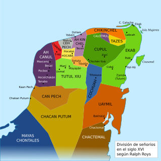
Chikinchel was the name of a Mayan chiefdom of the northern coast of Yucatán, before the arrival of the Spanish conquistadors in the sixteenth century. Chauacá has also been used to refer to this province, but apparently it was the name of the main city.
Ah Canul was the name of a Maya Kuchkabal of the northwest Yucatán Peninsula, before the arrival of the Spanish conquistadors in the 16th century.
Ah Kin Chel was the name of a Maya chiefdom or Kuchkabal of the northern Yucatán Peninsula, before the arrival of the Spanish conquistadors in the 16th century.
Can Pech was the name of a Maya chiefdom of the southwestern Yucatán Peninsula, before the arrival of the Spanish conquistadors in the sixteenth century. Can Pech was south of Ah Canul and north of Chakán Putum, on the coast of the Gulf of Mexico. In 1517, the population of its capital city was approximately 36,000, judging by the description of the city by Bernal Díaz del Castillo.

Ceh Pech is the name of a post-classic Maya ruling family and a province, or kuchkabal of the northern Yucatán Peninsula.
Chakán oregano of this land; 2) macaw tail feathers.’) is the name of one of the Mayan jurisdictions (kuchkabalob) that existed on the Yucatan Peninsula at the arrival of the Spanish conquistadors in the sixteenth century. Unlike other jurisdictions, Chakán did not seem to have a centralized government or control of a dominant Halach Uinik, as in the case of the provinces Ceh Pech or Ah Kin Chel. This is inferred from the fact that upon the Spaniards' arrival, Francisco de Montejo was well received by some local leaders (batabob), but not others, such as Ah Kin Chuy, who organized resistance in the region's eastern towns to repel Spanish settlers.
Chakán Putum was the name of a Mayan chiefdom of the southwestern Yucatán Peninsula, before the arrival of the Spanish conquistadors in the 16th century. Its capital city was a major Mayan port city with some 8000 buildings. The modern city of Champotón, Campeche was constructed at this location.
Cochuah is the name of one of the sixteen Mayan provinces into which the central Yucatán Peninsula was divided at the time of the arrival of the Spanish conquistadors in the sixteenth century.
Cupul or Kupul was the name of a Maya chiefdom at time of the Spanish conquest of Yucatán. Cupul was one of the most extensive and densely populated Maya provinces on the Yucatán Peninsula. It was formed in the mid-fifteenth century after the fall of Mayapan and reached its maximum power during the sixteenth century, at the time of their own Spanish conquest led by the adelantado Francisco de Montejo. According to the Encyclopedia Yucatán in time, the Mayan voice ku-pul, means that throws the bouncing, giving a connotation referring to the Mayan ballplayers that existed in the region.
Hocabá-Homún, Hokabá-Homún or Hocabá was the name of a Maya Kuchkabal of the northwestern Yucatán Peninsula, before the arrival of the Spanish conquistadors in the sixteenth century.

The League of Mayapan was a confederation of Maya states in the Postclassic period of Mesoamerica on the Yucatan Peninsula.
Halach uinik or halach uinic was the name given to the supreme ruler, overlord or chief, as they were called in the colonial period of a Maya kuchkabal.

Chetumal, or the Province of Chetumal, was a Postclassic Maya state of the Yucatan Peninsula, in the Maya Lowlands.


