Chikinchel

Last updated

Chiefdoms of Yucatan: marked 10 Cacicazgos mayas.jpg
Chiefdoms of Yucatán: marked 10

Chikinchel (also called Chauacá)(in Yucatec Mayan: Chikinchel de Chinkín) was the name of a Mayan chiefdom of the northern coast of Yucatán, before the arrival of the Spanish conquistadors in the sixteenth century. [1] Chauaca has also been used to name this province, but apparently it was the name of the main city.

Maya civilization Mesoamerican civilization

The Maya civilization was a Mesoamerican civilization developed by the Maya peoples, and noted for its logosyllabic script—the most sophisticated and highly developed writing system in pre-Columbian Americas—as well as for its art, architecture, mathematics, calendar, and astronomical system. The Maya civilization developed in an area that encompasses southeastern Mexico, all of Guatemala and Belize, and the western portions of Honduras and El Salvador. This region consists of the northern lowlands encompassing the Yucatán Peninsula, and the highlands of the Sierra Madre, running from the Mexican state of Chiapas, across southern Guatemala and onwards into El Salvador, and the southern lowlands of the Pacific littoral plain.

A chiefdom is a form of hierarchical political organization in non-industrial societies usually based on kinship, and in which formal leadership is monopolized by the legitimate senior members of select families or 'houses'. These elites form a political-ideological aristocracy relative to the general group.

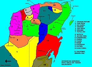
After the destruction of Mayapan (1441–1461), in the Yucatán Peninsula, it created rivalries among the Maya, and formed 16 separate jurisdictions, called Kuchkabals. In each Kuchkabal there was a Halach Uinik (in Mayan: Halach Uinik), who was the chief with the most political, judicial, and militaristic authority and lived in a principal city considered the capital of the jurisdiction.

Mayapan

Mayapan, , is a Pre-Columbian Maya site a couple of kilometers south of the town of Telchaquillo in Municipality of Tecoh, approximately 40 km south-east of Mérida and 100 km west of Chichen Itza; in the state of Yucatán, Mexico. Mayapan was the political and cultural capital of the Maya in the Yucatán Peninsula during the Late Post-Classic period from the 1220s until the 1440s. Estimates of the total city population are 15,000–17,000 persons, and the site has more than 4,000 structures within the city walls, and additional dwellings outside.

Kuchkabal

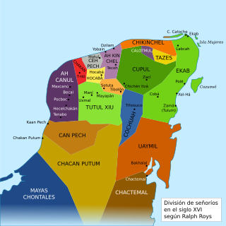
The Kuchkabal, Ah Kuch-Kab, or Ah Cuch-Cab were the forms of government used by the pre-Columbian nations of the Yucatan Peninsula. There were somewhere between 16 and 24 kuchkabalob in the 16th century. Kuchkabal could also refer to the ruling family.

Halach uinik or halach uinic was the name given to the supreme ruler, overlord or chief, as they were called in the colonial period of a Maya kuchkabal.

Historical Dates and Territories

It bordered the Tazes and Cupul in the south, Ah Kin Chel in the west, and Ekab in the east, which separated an area of swamps and, to the north, a large portion of the coast of the Yucatán Peninsula. The area provided an abundance of animals to hunt and salt and salt to mine (it was the leading producer on the peninsula), although unhealthy conditions caused dignitaries to live in remote villages along the coast.

Cupul

Cupul or Kupul, was the name of a Maya chiefdom at time of the Spanish conquest of Yucatán. Cupul was one of the most extensive and densely populated Maya provinces on the Yucatán Peninsula. It was formed in the mid-fifteenth century after the fall of Mayapan and reached its maximum power during the sixteenth century, at the time of their own Spanish conquest led by the adelantado Francisco de Montejo. According to the Encyclopedia Yucatán in time, the Mayan voice ku-pul, means that throws the bouncing, giving a connotation referring to the Mayan ballplayers that existed in the region.

Ah Kin Chel

Ah Kin Chel was the name of a Maya chiefdom or Kuchkabal of the northern Yucatán Peninsula, before the arrival of the Spanish conquistadors in the sixteenth century.

Ekab Mayan chiefdom

Ekab or Ecab was the name of a Mayan chiefdom of the northeastern Yucatán Peninsula, before the arrival of the Spanish conquistadors in the sixteenth century. In the fifteenth century most of Yucatán was controlled by the League of Mayapan. By 1441 there was civil unrest. The provinces of the League rebelled and formed sixteen smaller states. These states were called Kuchkabals. Most Kuchkabals were ruled by a Halach Uinik, but Ekab wasn't. It was divided up into several Batabil. Each Batabil was ruled over by a leader called a Batab. In Ekab the Batabs were supposed to have equal power, but the Batabs on Cozumel had much more power than the others.

Chikinchel does not appear to have been a united providence. Chauaca fought frequently with local rivals, like Sinsimato and Dzonotaké. [2] However, salt united the inhabitants of the jurisdiction because they prevented outsiders from Ah Kin Chel and the south from going where valuable chloride was produced.

Related Research Articles

Ah Canul

Ah Canul was the name of a Maya Kuchkabal of the northwest Yucatán Peninsula, before the arrival of the Spanish conquistadors in the sixteenth century.

Can Pech

Can Pech was the name of a Maya chiefdom of the southwestern Yucatán Peninsula, before the arrival of the Spanish conquistadors in the sixteenth century. Can Pech was south of Ah Canul and north of Chakán Putum, on the coast of the Gulf of Mexico. In 1517 the population of the capital city Campeche was approximately 36,000.

Ceh Pech

Ceh Pech is the name of a post-classic Maya ruling family and a province, or kuchkabal of the northern Yucatán Peninsula.

Chakán Putum

Chakán Putum was the name of a Mayan chiefdom of the southwestern Yucatán Peninsula, before the arrival of the Spanish conquistadors in the sixteenth century. It was named after the capital city Chakan Putum. The city had approximately 8000 houses. It was a major port.

Cochuah

Cochuah is the name of one of the sixteen Mayan provinces into which the central Yucatán Peninsula was divided at the time of the arrival of the Spanish conquistadors in the sixteenth century.

Hocabá-Homún

Hocabá-Homún, Hokabá-Homún or Hocabá was the name of a Maya Kuchkabal of the northwestern Yucatán Peninsula, before the arrival of the Spanish conquistadors in the sixteenth century.

Tutul-Xiu

Tutul-Xiu, also Tutul Xiues or Mani, was the name of a Mayan chiefdom of the central Yucatán Peninsula with capital in Maní, before the arrival of the Spanish conquistadors in the sixteenth century.

Sotuta human settlement in Mexico

Sotuta is a small town and municipality of the Mexican state of Yucatán, and also was the name of a Mayan chiefdom of the northern central Yucatán Peninsula, before the arrival of the Spanish conquistadors in the sixteenth century.

League of Mayapan

The League of Mayapan was a confederation of Maya states in the post classic period of Mesoamerica on the Yucatan peninsula.

Mo-Chel was the first Halach Uinik of the Kuchkabal Ah Kin Chel. He started the rule of the Chel family and the political state ruled by them. He was originally a nobleman, the son in law of one of the principal priests at Mayapan. Another priest Ah Xupan Nauat married his daughter Namox Chel to Mo. He is said to have foreseen the destruction of the League of Mayapan, and he fled with some followers to Tecoh near Izamal, where he established an independent state. He named the nation Ah Kin Chel.

Batab, which is Mayan for 'Local village chief, chieftain', was the name given to the chief of a town or village called batabil.

Tekal de Venegas Municipality Municipality in Yucatán, Mexico

Tekal de Venegas Municipality is one of the 106 municipalities in the Mexican state of Yucatán containing (95.80 km2) of land and located roughly 80 km east of the city of Mérida.

Dzilam González Municipality Municipality in Yucatán, Mexico

Dzilam González Municipality is one of the 106 municipalities in the Mexican state of Yucatán containing 545.45 square kilometres (210.60 sq mi) of land and located roughly 90 kilometres (56 mi) northeast of the city of Mérida. It is located in the former Province of Ah Kin Chel Province to the north of Izamal, about 10 kilometres (6.2 mi) inland from the coast. It was once the port of Dzilam which has now receded inland is known as Dzilam González. The agricultural produces of the area are corn, onions, beans and fruit.

Teya Municipality Municipality in Yucatán, Mexico

Teya Municipality is one of the 106 municipalities in the Mexican state of Yucatán containing (65.15 km2) of land and located roughly 65 km northeast of the city of Mérida.

Yobaín Municipality Municipality in Yucatán, Mexico

Yobaín Municipality is one of the 106 municipalities in the Mexican state of Yucatán containing (81.75 km2) of land and located roughly 70 km northeast of the city of Mérida.

References