Lake Jackson Mounds Archaeological State Park (8LE1) is one of the most important archaeological sites in Florida, the capital of chiefdom and ceremonial center of the Fort Walton Culture inhabited from 1050–1500. The complex originally included seven earthwork mounds, a public plaza and numerous individual village residences.

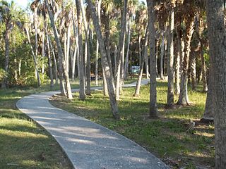
Crystal River State Archaeological Site is a 61-acre (250,000 m2) Florida State Park located on the Crystal River and within the Crystal River Preserve State Park. The park is located two miles (3 km) northwest of the city of Crystal River, on Museum Point off U.S. 19/98.
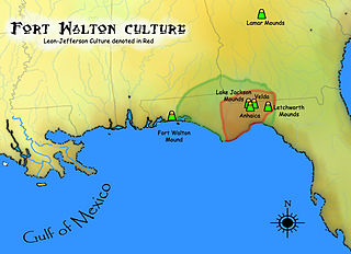
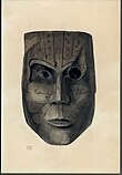
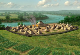
The Fort Walton culture is the term used by archaeologists for a late prehistoric Native American archaeological culture that flourished in southeastern North America from approximately 1200~1500 CE and is associated with the historic Apalachee people.
The Leon-Jefferson Culture is the term used by archaeologists for a protohistoric Native American archaeological culture that flourished in southeastern North America from approximately 1500–1704 CE and is associated with the historic Apalachee people. It was located in and named for the present day Leon and Jefferson counties in northern Florida of the Southeastern United States
The Madira Bickel Mound State Archaeological Site is an archaeological site on Terra Ceia Island in northwestern Palmetto, Florida, United States. It is located on Bayshore Drive, west of U.S. 19, a mile south of I-275. On August 12, 1970, it was added to the U.S. National Register of Historic Places. It is also a Florida State Park.
Big Mound City (8PB48) is a prehistoric site near Canal Point, Florida, United States. It is located 10 miles east of Canal Point, off U.S. Route 98. On May 24, 1973, it was added to the U.S. National Register of Historic Places. It is located inside the J.W. Corbett Wildlife Management Area.

The Fort Walton Mound (8OK6) is an archaeological site located in present-day Fort Walton Beach, Florida, United States. The large platform mound was built about 850 CE by the Pensacola culture, a local form of the Mississippian culture. Because of its significance, the mound was designated a National Historic Landmark in 1964.
The Yent Mound (8FR5) is a Santa Rosa-Swift Creek culture archaeological site located on Alligator Harbor west of St. Teresa, Florida. It is on the east side of County Road 370, approximately 2.5 miles from the junction of U.S. Route 98. On May 24, 1973, it was added to the U.S. National Register of Historic Places.
The Hickory Ridge Cemetery Archeological Site (8ES1280) is an archaeological site in Pensacola, Escambia County Florida. It is located north of Big Lagoon and west of Pensacola. During excavations in the 1980s carbon dating was done on burnt wood fragments associated with burials in the mound, with a determination that the site had been used c. 1450. Analysis of ceramics suggested it was a Mississippian culture site, probably from the Late Bottle Creek Phase or Early Bear Point Phases of the Pensacola culture. It was a cemetery associated with a village nearby, (8ES1052). On September 22, 2000, it was added to the U.S. National Register of Historic Places.
The Cayson Mound and Village Site (8CA3) is a prehistoric archaeological site located near Blountstown, Florida. It is located three miles southeast of Blountstown, on the Apalachicola River. The site was occupied by peoples of the Fort Walton Culture. On March 15, 1976, it was added to the U.S. National Register of Historic Places.
The Yon Mound and Village Site (8LI2) is a prehistoric archaeological site located two miles west of Bristol, Florida on the east bank of the Apalachicola River. The site was occupied by peoples of the Fort Walton Culture. On December 15, 1978, it was added to the U.S. National Register of Historic Places as reference number 78000952.

The Safety Harbor site is an archaeological site in Philippe Park at 2525 Philippe Parkway in Safety Harbor, Florida, United States. It is the type site for the Safety Harbor culture, and includes the largest remaining mound in the Tampa Bay area. It was designated a National Historic Landmark in 1964.
The Pierce Site is a Pre-Columbian archaeological site in Apalachicola, Florida. It is located approximately 1 mile northwest of Apalachicola on 12th Street. On January 11, 1974, it was added to the U.S. National Register of Historic Places. It was occupied during the Middle Woodland Period, which includes ceramics of early Weeden Island and Swift Creek types. It also was occupied during the late prehistoric Fort Walton Period.

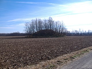
The Roberts Mound is a Native American mound in the southwestern part of the U.S. state of Ohio, United States. Located northwest of Auburn in Butler County, the mound sits in Section 36 of Reily Township; it is the only mound in the far southeastern part of the township.
The Austin Brown Mound, also known as the "Dwight Fullerton Mound," is a subconical Native American mound located northwest of the city of Chillicothe in Ross County, Ohio, United States. In 1897, the Ohio Historical Society sponsored an excavation of the mound under the leadership of Clarence Loveberry, who oversaw the digging of a large tunnel into the mound's side. Loveberry's investigation yielded artifacts of the Adena culture and evidence of rotten logs on the floor of the mound, but in publishing the results of his excavation, he observed that neither a tomb nor any isolated burials were discovered within the mound. Since 1897, other Adena mounds have been excavated and shown to have wooden tombs in off-center locations, presumably to complicate the efforts of those who would loot the mounds; accordingly, it is possible that the Brown mound likewise has an off-center tomb.

The Adams site (15FU4) is a Mississippian culture archaeological site located near Hickman in Fulton County, Kentucky, on Bayou de Chien, a creek that drains into the nearby Mississippi River.

The Jackson Mound is a Native American mound in the south-central portion of the U.S. state of Ohio. Located north of Pancoastburg in Fayette County, it measures approximately 75 feet (23 m) in diameter and 5.5 feet (1.7 m) in height. The mound has never been excavated, making the certain identification of its builders impossible; however, its location on a high terrace above a relatively small stream suggests that it was built by the Adena culture, which favored such sites for its many mounds. If true, it was originally more conical in shape, and it is likely to cover the remains of a wooden charnel house built by the Adena.

Poverty Point State Historic Site/Poverty Point National Monument is a prehistoric earthwork constructed by the Poverty Point culture, located in present-day northeastern Louisiana. Evidence of the Poverty Point culture extends throughout much of the Southeastern Woodlands of the Southern United States. The culture extended 100 miles (160 km) across the Mississippi Delta and south to the Gulf Coast.
The Annis Mound and Village site is a prehistoric Middle Mississippian culture archaeological site located on the bank of the Green River in Butler County, Kentucky, several miles northwest of Morgantown in the Big Bend region. It was occupied from about 800 CE to about 1300 CE.