Maritime archaeology is a discipline within archaeology as a whole that specifically studies human interaction with the sea, lakes and rivers through the study of associated physical remains, be they vessels, shore-side facilities, port-related structures, cargoes, human remains and submerged landscapes. A specialty within maritime archaeology is nautical archaeology, which studies ship construction and use.
Underwater archaeology is archaeology practiced underwater. As with all other branches of archaeology, it evolved from its roots in pre-history and in the classical era to include sites from the historical and industrial eras.

A shipwreck is the wreckage of a ship that is located either beached on land or sunken to the bottom of a body of water. Shipwrecking may be intentional or unintentional. There were approximately three million shipwrecks worldwide as of January 1999, according to Angela Croome, a science writer and author who specialized in the history of underwater archaeology.

Wreck diving is recreational diving where the wreckage of ships, aircraft and other artificial structures are explored. The term is used mainly by recreational and technical divers. Professional divers, when diving on a shipwreck, generally refer to the specific task, such as salvage work, accident investigation or archaeological survey. Although most wreck dive sites are at shipwrecks, there is an increasing trend to scuttle retired ships to create artificial reef sites. Diving to crashed aircraft can also be considered wreck diving. The recreation of wreck diving makes no distinction as to how the vessel ended up on the bottom.

Barrier islands are a coastal landform, a type of dune system and sand island, where an area of sand has been formed by wave and tidal action parallel to the mainland coast. They usually occur in chains, consisting of anything from a few islands to more than a dozen. They are subject to change during storms and other action, but absorb energy and protect the coastlines and create areas of protected waters where wetlands may flourish. A barrier chain may extend for hundreds of kilometers, with islands periodically separated by tidal inlets. The largest barrier island in the world is Padre Island of Texas, United States, at 113 miles (182 km) long. Sometimes an important inlet may close permanently, transforming an island into a peninsula, thus creating a barrier peninsula, often including a beach, barrier beach. Though many are long and narrow, the length and width of barriers and overall morphology of barrier coasts are related to parameters including tidal range, wave energy, sediment supply, sea-level trends, and basement controls. The amount of vegetation on the barrier has a large impact on the height and evolution of the island.
A raised beach, coastal terrace, or perched coastline is a relatively flat, horizontal or gently inclined surface of marine origin, mostly an old abrasion platform which has been lifted out of the sphere of wave activity. Thus, it lies above or under the current sea level, depending on the time of its formation. It is bounded by a steeper ascending slope on the landward side and a steeper descending slope on the seaward side. Due to its generally flat shape, it is often used for anthropogenic structures such as settlements and infrastructure.

In maritime law, flotsam,jetsam,lagan, and derelict are specific kinds of shipwreck. The words have specific nautical meanings, with legal consequences in the law of admiralty and marine salvage. A shipwreck is defined as the remains of a ship that has been wrecked, whether it has sunk or is floating on the surface of the water.

La Belle was one of Robert de La Salle's four ships when he explored the Gulf of Mexico with the ill-fated mission of starting a French colony at the mouth of the Mississippi River in 1685. La Belle was wrecked in present-day Matagorda Bay the following year, dooming La Salle's Texas colony to failure. The wreckage of La Belle lay forgotten until it was discovered by a team of state archaeologists in 1995. The discovery of La Salle's flagship was regarded as one of the most important archaeological finds of the century in Texas, and a major excavation was launched by the state of Texas that, over a period of about a year, recovered the entire shipwreck and over a million artifacts.

San Pedro Underwater Archaeological Preserve State Park is a Florida State Park located in 18 feet (5.5 m) of water, approximately 1.25 nautical miles (2.32 km) south of Indian Key. It became the second Florida Underwater Archaeological Preserve when it opened to the public in 1989. The heart of the park is the San Pedro, a submerged shipwreck from a 1733 Spanish flotilla, around which visitors can dive and snorkel. The San Pedro, a 287-ton Dutch-built vessel, and 21 other Spanish ships under the command of Rodrigo de Torres left Havana, Cuba, on Friday, July 13, 1733, bound for Spain. The San Pedro carried a cargo of 16,000 silver Mexican pesos and crates of Chinese porcelain. A hurricane struck the fleet, while entering the Straits of Florida, and sank or swamped most of the fleet. The wrecksite includes an "eighteenth century anchor, replica cannons, ballast stones encrusted with coral, a dedication plaque, and a mooring buoy system." The wreck was added to the U.S. National Register of Historic Places on May 31, 2001.

Treasure hunting is the physical search for treasure. For example, treasure hunters try to find sunken shipwrecks and retrieve artifacts with market value. This industry is generally fueled by the market for antiquities.

The archaeology of shipwrecks is the field of archaeology specialized most commonly in the study and exploration of shipwrecks. Its techniques combine those of archaeology with those of diving to become Underwater archaeology. However, shipwrecks are discovered on what have become terrestrial sites.

The Lofthus is a Norwegian shipwreck near Boynton Beach, Florida, United States. Built in 1868 in Sunderland, England by T.R. Oswald, the 222-foot iron-hulled vessel was originally christened Cashmere and rigged as a three masted barque. She was painted with false gunports to ward off Sumatran and Javanese pirates. After a career in the East Indian trade Cashmere was sold to a Norwegian firm, renamed Lofthus, and used in the American trade. On February 4, 1898, the Lofthaus wrecked in a storm en route to Buenos Aires, Argentina from Pensacola, Florida. The crew of 16 men, as well as the ship's cat and dog were rescued by the passing vessel Three Friends, which was smuggling guns to Cuba. The ship, however, was declared a loss as it could not be removed from the shallow reef. The cargo, primarily lumber, was salvaged and brought ashore by locals and reportedly used to build homes in the Boynton Beach area.
Urca de Lima is a Spanish shipwreck near Fort Pierce, Florida, United States. She was part of the 1715 Treasure Fleet, one of the numerous Spanish treasure fleets sailing between Spain and its colonies in the Americas. The wreck is located north of Fort Pierce Inlet, 200 yards off the shore from Jack Island Park. It became the first Florida Underwater Archaeological Preserve when dedicated in 1987. This was followed on May 31, 2001 with its addition to the U.S. National Register of Historic Places.

The 1715 Treasure Fleet was actually a combination of two Spanish treasure fleets returning from the New World to Spain, the "Nueva España Fleet", under Capt.-General Don Juan Esteban de Ubilla, and the "Tierra Firme Fleet", under Don Antonio de Echeverz y Zubiza. At two in the morning on Wednesday, July 31, 1715, seven days after departing from Havana, Cuba, all eleven ships of the fleet were lost in a hurricane along the east coast of Florida. A 12th ship, the French frigate "Le Grifon", had sailed with the fleet. Its captain was unfamiliar with the Florida coastline and elected to stay further out to sea. The "Grifon" safely returned to Europe.

Robert F. Marx was an American pioneer in scuba diving, a prolific author, and was best known for his work as an avocational marine archaeologist. Over his career, he discovered over 5000 shipwrecks in over 60 countries. Although some accused him of treasure hunting, fellow avocational archeologist E. Lee Spence described Marx as the "true father of underwater archaeology". Marx also helped write UNESCO legislation regarding shipwrecks.

George Robert Fischer was an American underwater archaeologist, considered the founding father of the field in the National Park Service. A native Californian, he did undergraduate and graduate work at Stanford University, and began his career with the National Park Service in 1959, which included assignments in six parks, the Washington, D.C. Office, and the Southeast Archaeological Center from which he retired in 1988. He began teaching courses in underwater archaeology at Florida State University in 1974 and co-instructed inter-disciplinary courses in scientific diving techniques. After retirement from the NPS his FSU activities were expanded and his assistance helped shape the university's program in underwater archaeology.

The Key West Shipwreck Museum is located in Key West, Florida, United States. It combines actors, films and actual artifacts to tell the story of 400 years of shipwreck salvage in the Florida Keys. The museum itself is a re-creation of a 19th-century warehouse built by wrecker tycoon Asa Tift. Many of the artifacts on display are from the 1985 rediscovery of the wrecked vessel Isaac Allerton, which sank in 1856 on the Florida Keys reef and turned out to be one the richest shipwrecks in Key West's history, having resulted in the Federal Wrecking Court's largest monetary award for the salvage of a single vessel.
J&J Hunt Site (8JE740) is an inundated prehistoric archaeological site located 6 km off the coast of northwestern Florida. The site which was discovered in 1989 is located in 3.7 to 4.6 m of salt water in the Gulf of Mexico along the PaleoAucilla River. In prehistory the site had at least two different occupations: a Late Paleoindian-Early Archaic and Middle Archaic. The J&J Hunt site was a major focus of the PaleoAucilla Prehistory Project conducted by Michael K. Faught.

The conservation and restoration of shipwreck artifacts is the process of caring for cultural heritage that has been part of a shipwreck. Oftentimes these cultural artifacts have been underwater for a great length of time. Without conservation, most artifacts would perish and important historical data would be lost. In archaeological terms, it is usually the responsibility of an archaeologist and conservator to ensure that material recovered from a shipwreck is properly cared for. The conservation phase is often time-consuming and expensive, which is one of the most important considerations when planning and implementing any action involving the recovery of artifacts from a shipwreck.
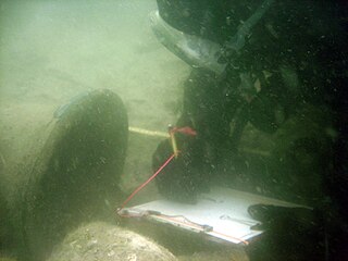
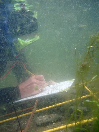
Archaeological diving is a type of scientific diving used as a method of survey and excavation in underwater archaeology. The first known use of the method comes from 1446, when Leon Battista Alberti explored and attempted to lift the ships of Emperor Caligula in Lake Nemi, Italy. Just a few decades later, in 1535, the same site saw the first use of a sophisticated breathing apparatus for archaeological purposes, when Guglielmo de Lorena and Frances de Marchi used an early diving bell to explore and retrieve material from the lake, although they decided to keep the blueprint of the exact mechanism secret. The following three centuries saw the gradual extension of diving time through the use of bells and submersing barrels filled with air. In the 19th century, the standard copper helmet diving gear was developed, allowing divers to stay underwater for extended periods through a constant air supply pumped down from the surface through a hose. Nevertheless, the widespread utilisation of diving gear for archaeological purposes had to wait until the 20th century, when archaeologists began to appreciate the wealth of material that could be found under the water. This century also saw further advances in technology, most important being the invention of the aqualung by Émile Gagnan and Jacques-Yves Cousteau, the latter of whom would go on to use the technology for underwater excavation by 1948. Modern archaeologists use two kinds of equipment to provide breathing gas underwater: self-contained underwater breathing apparatus (SCUBA), which allows for greater mobility but limits the time the diver can spend in the water, and Surface-supplied diving equipment, which is safer but more expensive, and can only be used in shallower waters.