Ortona Prehistoric Village

Last updated

The Ortona Prehistoric Village is an archaeological site adjacent to the community of Ortona in northeastern Glades County, Florida, north of the Caloosahatchee River and west of Lake Okeechobee, consisting of mounds, canals and other features. [1] Part of the site is currently in the Glades County-owned Ortona Indian Mound Park, but much remains in private hands. The site has been extensively modified by 20th-century activities, including the construction of a county road and a cemetery, sand mining operations, and improvements to pasture land.

Contents

Environs

The Ortona mounds are located about 3 miles (4.8 km) north of the present-day Caloosahatchee River. Until late in the 19th century, the Caloosahatchee River was fed by a series of lakes starting from Lake Hicpochee, and including Lettuce Lake, Bonnet Lake and Flirt Lake. A waterfall and set of rapids at the lower end of Flirt Lake marked the beginning of the river. The rapids were close to 1 mile (1.6 km) long, with a drop in elevation of about 10 feet (3.0 m). Lake Hicpochee, about 9,000 acres (3,600 ha) in area, was only 3 miles (4.8 km) from Lake Okeechobee, but there was no connection between the two lakes before the late 19th century. Water flowed from Lake Hicpochee westward into Lettuce Lake and then Bonnet Lake. When the water was high the two lakes merged. From Bonnet Lake water flowed into Lake Flirt, which was about 1,000 acres (400 ha) in area and 5 miles (8.0 km) long. All of the lakes were surrounded by extensive wetlands. [2]

In 1881 Hamilton Disston, as part of a scheme to drain large areas of wetlands in the interior of Florida, had a canal dredged from Lake Okeechobee to Lake Hicpochee and through the lakes and wetlands to the west. His company removed the rock ledge that formed the falls and rapids below Lake Flirt, and straightened the upper reaches of the Caloosahatchee River. Various state and federal projects have widened and deepened the river since then. [3] The conversion of the Caloosahatchee River into a canal drained Lake Flirt and the wetlands descending from Lake Hicpochee. [4]

Site components

The site was extensively altered during the 20th century, and many of the features were destroyed or heavily damaged. Archaeologists have used early descriptions and maps of the site, as well as aerial photographs taken in the middle of the 20th century, to construct a partial picture of the site before it was altered. [5]

Canals

The remains of two linear canals connect the Ortona site with the Caloosahatchee River. One canal runs about 3.2 kilometres (2.0 mi) southeast from the site to a natural waterway connecting to the river. The other canal runs southwest from the site about 3.7 kilometres (2.3 mi) to what was Lake Flirt on the old river bed (the Caloosahatchee River was canalized in the 20th century). [6] While the routes of the canals can be traced on old maps and aerial photos, they have been significantly altered and obscured by human actions in the 20th century. [7]

Early maps show an “Indian Trail” running from Fisheating Creek that crossed the wetlands east of Lake Flirt (and south of the Ortona site) at a ford. The Seminole Wars Fort Thompson was located at the rapids below (west of) Lake Flirt. [8]

The two canals were fed by a slough called Turkey Creek, which flowed towards the mounds from the north. The western canal (8GL4A) connected a small, round pond near the mounds to an arm of Lake Flirt called Cypress Branch. The eastern canal (8GL4B) started near the mounds but does not appear to have been connected to the pond. Wheeler speculates that the two canals may have been connected by Turkey Slough. A 1950 map based on aerial photos shows a short branch of the eastern canal connecting to a mound or group of mounds. Much of the eastern canal may have been re-dredged as a drainage canal during the 20th century. [9]

Measurements made in the 20th century indicate that the canals were about 1.2 metres (3.9 ft) deep and 3 metres (9.8 ft) wide. The canals had flat bottoms and sloped sides, with spoil along their sides. [10] A surviving portion of the eastern canal that was about to be destroyed in a sand mining operation was examined in 1997 by archaeologists. Trenches were cut through the canal to determine its history. Examination of the soil profiles in the trenches revealed that the canal was originally 6.7 to 9.1 metres (22 to 30 ft) wide at the top and 4.6 to 6.1 metres (15 to 20 ft) wide at the bottom of the canal, and 1 to 1.2 metres (3.3 to 3.9 ft) deep. Radiocarbon dates from samples of organic material recovered from the trenches indicate that the canal may have been dug as much as 1,900 years ago. A sample from the lowest layer was 1,600 to 1,900 years old. Two other samples above the original bottom of the canal, presumably deposited on sediment that had accumulated in the canal, were 1,100 to 1,750 years old. [11]

Both canals slope from the area of the mounds to the river, dropping just over 1 foot (0.30 m) in every 1,000 feet (300 m). The slope was enough to maintain a flow of water through the canals without causing excessive erosion. Wheeler states that the canals were primarily for canoe traffic, although, as a secondary effect, they may have helped drain the area around the mounds. “The canals demonstrate a complex knowledge of local topography and hydraulic features.” [12]

The Ortona canals differ from other pre-historic canals in southwest Florida, as having had a flow induced by a drop in elevation. The Mud Lake, Snake Bight and Naples canals were at sea level, subject only to tidal flows. The Pine Island and Cape Coral canals were static canals, closed at both ends and at intermediate points. In addition, the Ortona Canals may have been used to bypass a marshy section of the Caloosahatchee watershed and bring canoe traffic between Lake Okeechobee and the lower Caloosahatchee to the Ortona site, while the other canals provided shortcuts that also avoided taking canoes into open, and possibly rough, water. [13]

Major mounds

On the east side of the site is a large mound (8GL5). Estimates of the size of the mound have varied over the years. In 1918 the mound was described as being 160 feet (49 m) by 130 feet (40 m), and 30 feet (9.1 m) tall. In 1948 the dimensions were given as 200 feet (61 m) by 200 feet (61 m), and 16 feet (4.9 m) tall, with part of the mound removed for road fill. By the 1990s the entire center of the mound had been removed, leaving a rim around the outside of the mound. Pits (presumably dug by "pot hunters") were reported in the mound as early as 1918, but there is no report of any human remains or artifacts being found in the mound. [14]

Mound A (8GL80) is on the east side of Turkey Creek. The mound is about 38 to 39 metres (125 to 128 ft) across and 2.5 metres (8.2 ft) tall. It is one of the best-preserved mounds at Ortona. The mound is a midden, with animal bones and human artifacts. The soil in the mound is noticeably darker than that of other mounds at the site. [14]

To the west of Turkey Creek is Mound B. Mound B was largely destroyed when it was mined for fill. Historical accounts and aerial photos indicate that the mound was 152 metres (499 ft) long, 21 metres (69 ft) wide and 5 feet (1.5 m) high. It has been described as being shaped like a loaf of bread. Test excavations on the remnants of the mound indicate that it was made primarily of sand, with some midden material mixed in. [15]

Mound C has also been largely destroyed by mining. It was originally about 30.3 metres (99 ft) in diameter and about 1 metre (3.3 ft) high. Shards were observed on the surface of the mound in 1974. [15]

Mound D was another "breadloaf-shaped" mound that was largely destroyed in the later 20th century. It was originally about 152 metres (499 ft) long, with a width that varied between 20 and 25 metres (66 and 82 ft). Stereoptic aerial photos from 1949 suggest that the mound had conical elevations at each end of the mound, but both ends have been leveled. One remaining segment of the mound has been bulldozed, but is still about .5 metres (1.6 ft) high. Robert Carr was present when the northern end of the mound was destroyed, and observed that the upper 1 metre (3.3 ft) of the mound contained organically-stained sand and pottery shards. A 16 metres (52 ft) wide ramp on the west side of the mound shows in mid-20th century aerial photos. A "causeway" appears to have connected the north end of Mound D to Mound C, which is east of Mound D. [16]

Discovery and examination

The site first appears in the written record in 1839, when surveyors noted a large mound and two canals at the site. The canals were described in a Smithsonian Institution report in 1882, while the mounds were described in American Antiquarian in 1887. In the first half of the 20th century the site was visited and described by R. D. Wainwright, John Kunkel Small, Aleš Hrdlička, Henry B. Collins, John W. Griffin and John Mann Goggin. Goggin returned to the site in 1952 with some students to excavate part of the large mound. [17]

Glades County created the Ortona Indian Mound Park in 1989. [18]

History

Many archaeologists believe that the village was first settled around 300 A.D., and that the village lasted till 1150 A.D. They also believe that the height of the occupation was from 550–800 A.D. Ortona was built at a critical intersection of a north-south and an east-west trade routes.

The longest canals built by Indians in North America, built by the Calusa, connected the major waterway, the Caloosahatchee River at Ortona, because the site was just below the falls. Former state archaeologist Ryan J. Wheeler, [19] made researches on the Ortona Canals using government maps and areal photography. Wheeler believes the canals traveled 20 miles, an incredible feat of hydraulic engineering by a group of hunter-gathers. Wheeler was instrumental in having the Mud Lake Canal, a 3.9 mile long Calusa canal in the Everglades, designated a National Historic Landmark.

The restoration and further study of the Ortona Canals is being undertaken by Robert S. Carr and his organization, the Florida Archaeological Conservancy. [1] Architect and anthropologist, Richard Thornton, [20] has researched, as well as, created village layouts, showing the various mounds and features. His ideas and layouts are online at his site, access genealogy. Thornton was the first to raise the point concerning the lack of barricades and fortification of the village. Southeast archaeologist George R. Milner [21] conducted research on trends by prehistoric tribes of violence and warfare. Ortona as well as Fort Center were built at a brief window of peace and trade that started around 100 B.C. and lasted till 400 A.D.. Florida archaeologists such as Milanich, believe that features at Ortona were the result of contact by societies associated with the Mississippian culture due to similarities in building types.

The recent dating of the neighboring Fort Center site to 800–500 B.C. indicates that most likely, the culture that built Ortona, Fort Center, Big Mound City, and Tony's Mound had a unifying religion, trade and engineering skills and feats many centuries before the Hopewell and Mississippi culture.

Notes

  1. 1 2 Derr, Mark (2002-07-23). "Network of Waterways Traced to Ancient Florida Culture". The New York Times. ISSN   0362-4331 . Retrieved 2019-01-10.
  2. Lodge, Thomas E. (1994). "The Caloosahatchee: Historic Condition". The Everglades Handbook: Understanding the Ecosystem (4 ed.). CRC Press. ISBN   9781498742955.
  3. "Dredging History of Southwest Florida Inland Waterways" (PDF). National Sea Grant Library. Archived from the original (PDF) on December 23, 2004. Retrieved July 18, 2018.
  4. Wheeler: 266, 270.
  5. Carr, et al. December 1995: 233.
  6. Carr, et el. December 1995: 233, 235
  7. Wheeler: 272.
  8. Wheeler: 266-268
  9. Wheeler: 270, 274
  10. Wheeler: 273.
  11. Carr, et al. March 2002: 3, 5, 15, 16.
  12. Wheeler: 272-274, 276, 278.
  13. Wheeler: 276-277.
  14. 1 2 Carr, et al. December 1995: 236.
  15. 1 2 Carr, et al. December 1995: 238.
  16. Carr, et al. December 1995: 238, 240.
  17. Carr, et al. December 1995: 230, 233.
  18. O'Phelan, Anne M. (February 9, 2016). "Ortona Indian Mound Park full of history". [Fort Myers] News-Press. Retrieved July 19, 2018.
  19. Wheeler
  20. Thornton
  21. Milner

Related Research Articles

<span class="mw-page-title-main">Everglades</span> Flooded grassland in southern Florida, United States

The Everglades is a natural region of tropical wetlands in the southern portion of the U.S. state of Florida, comprising the southern half of a large drainage basin within the Neotropical realm. The ecosystem it forms is not presently found anywhere else on earth. The system begins near Orlando with the Kissimmee River, which discharges into the vast but shallow Lake Okeechobee. Water leaving the lake in the wet season forms a slow-moving river 60 miles (97 km) wide and over 100 miles (160 km) long, flowing southward across a limestone shelf to Florida Bay at the southern end of the state. The Everglades experiences a wide range of weather patterns, from frequent flooding in the wet season to drought in the dry season. Throughout the 20th century, the Everglades suffered significant loss of habitat and environmental degradation.

<span class="mw-page-title-main">Moore Haven, Florida</span> City in Florida, United States

Moore Haven is a city in, and the county seat of, Glades County, Florida, United States. The population was 1,680 at the 2010 census. Moore Haven is located on the southwest shoreline of Lake Okeechobee.

<span class="mw-page-title-main">Canal Point, Florida</span> CDP in Florida, United States

Canal Point is a census-designated place (CDP) and unincorporated community in Palm Beach County, Florida, United States. Canal Point is located along the eastern shore of Lake Okeechobee, to the northeast of Pahokee and to the northwest of Bryant. The unincorporated community was originally inhabited by the Calusa tribe until almost 400 years ago. Whites began occupying the area in the 1900s decade, establishing an agrarian community. The completion of the West Palm Beach Canal in 1917 allowed crops to be shipped by boat to West Palm Beach and then to other areas of the country, while construction of Conners Highway in 1924 resulted in crops being transported by motor vehicle.

<span class="mw-page-title-main">Lake Okeechobee</span> Natural freshwater lake in Florida, United States

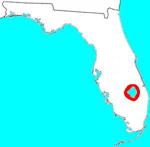
Lake Okeechobee, also known as Florida's Inland Sea, is the largest freshwater lake in the U.S. state of Florida. It is the tenth largest natural freshwater lake among the 50 states of the United States and the second-largest natural freshwater lake contained entirely within the contiguous 48 states, after Lake Michigan.

<span class="mw-page-title-main">Caloosahatchee River</span> River on the southwest coast of Florida, US

The Caloosahatchee River is a river on the southwest Gulf Coast of Florida in the United States, approximately 67 miles (108 km) long. It drains rural areas on the northern edge of the Everglades, east of Fort Myers. An important link in the Okeechobee Waterway, a manmade inland waterway system of southern Florida, the river forms a tidal estuary along most of its course and has become the subject of efforts to restore and preserve the Everglades.

<span class="mw-page-title-main">Okeechobee Waterway</span> Canal in Florida, United States of America

The Okeechobee Waterway or Okeechobee Canal is a relatively shallow artificial waterway in the United States, stretching across Florida from Fort Myers on the west coast to Stuart on Florida's east coast. The waterway can support tows such as barges or private vessels up to 50 feet wide x 250 feet long which draw less than 10 feet, as parts of the system, especially the locks may have low water depths of just ten feet. The system of channels runs through Lake Okeechobee and consists of the Caloosahatchee River to the west of the lake and the St. Lucie Canal east of the lake.

<span class="mw-page-title-main">Jaega</span> Native American chiefdom in Florida, US

The Jaega were Native Americans living in a chiefdom of the same name, which included the coastal parts of present-day Martin County and northern Palm Beach County, Florida at the time of initial European contact, and until the 18th century. The area occupied by the Jaega corresponds to the East Okeechobee Area, an archaeological culture that is part of, or closely related to, the Belle Glade culture. The name Jobé, or Jové[ˈxoβe], has been identified as a synonym of Jaega, a sub-group of the Jaega, or a town of the Jaega.

<span class="mw-page-title-main">Mayaimi</span> Native American people

The Mayaimi were Native American people who lived around Lake Mayaimi in the Belle Glade area of Florida from the beginning of the Common Era until the 17th or 18th century. In the languages of the Mayaimi, Calusa, and Tequesta tribes, Mayaimi meant "big water." The origin of the language has not been determined, as the meanings of only ten words were recorded before extinction. The linguist Julian Granberry states that the language of the Calusa, Mayaimi and Tequesta people is related to the Tunica language. The current name, Okeechobee, is derived from the Hitchiti word meaning "big water". The Mayaimis have no linguistic or cultural relationship with the Miamis of Great Lakes region. The city of Miami is named after the Miami River, which derived its name from Lake Mayaimi.

<span class="mw-page-title-main">Florida State Road 78</span>

State Road 78 is the Florida Department of Transportation designation of the highway that historically extended from Pine Island Center on the Gulf Coast of Florida to the northern tip of Lake Okeechobee. In the 1980s, two segments of the route were removed from state maintenance to county maintenance. More recently, SR 78 signs were removed from the four-mile-long stretch of US 27/SR 25 that was once a concurrency. All three sections are signed east–west, even though the easternmost section is actually a north–south route.

The Belle Glade culture, or Okeechobee culture, is an archaeological culture that existed from as early as 1000 BCE until about 1700 CE in the area surrounding Lake Okeechobee and in the Kissimmee River valley in the Florida Peninsula.

The Caloosahatchee culture is an archaeological culture on the Gulf coast of Southwest Florida that lasted from about 500 to 1750 AD. Its territory consisted of the coast from Estero Bay to Charlotte Harbor and inland about halfway to Lake Okeechobee, approximately covering what are now Charlotte, Lee, and Collier counties. At the time of first European contact, the Caloosahatchee culture region formed the core of the Calusa domain.

Robert (Bob) S. Carr is an American archaeologist and the current executive director of The Archaeological and Historical Conservancy, Inc. He specializes in Southeastern archaeology, with particular emphasis on archaeology in Florida. He has also conducted fieldwork in the Bahamas.

Big Mound City (8PB48) is a prehistoric site near Canal Point, Florida, United States. It is located 10 miles east of Canal Point, off U.S. Route 98. On May 24, 1973, it was added to the U.S. National Register of Historic Places. It is located inside the J.W. Corbett Wildlife Management Area.

The Pineland Archeological District is a U.S. historic district located on Pine Island, near Pineland, Florida, and next to Pine Island Sound. The site was occupied by people of the Caloosahatchee culture, known as the Calusa in historic times, from 500 BCE until after 1700. The site includes shell and sand mounds and other structures and prehistoric canals and artificial lakes. It also includes structures from the late 19th and early 20th centuries.

Dismal Key is a small island, part of the Ten Thousand Islands archipelago in the Gulf of Mexico off the coast of Florida. The island is artificial, constructed by people of the Glades culture. Construction of the island proceeded in stages over some 1,500 years following the end of the Archaic period in Florida. Occupation probably ended a couple of centuries before the arrival of Europeans in Florida. Dismal Key was occupied by several hermits in the 20th century.

<span class="mw-page-title-main">St. Johns culture</span> Archaeological culture in North America

The St. Johns culture was an archaeological culture in northeastern Florida, USA that lasted from about 500 BCE until shortly after European contact in the 17th century. The St. Johns culture was present along the St. Johns River and its tributaries (including the Oklawaha River, and along the Atlantic coast of Florida from the mouth of the St. Johns River south to a point east of the head of the St. Johns River, near present-day Cocoa Beach, Florida. At the time of first European contact, the St. Johns culture area was inhabited by speakers of the Mocama, Agua Fresca and Acuera dialects of the Timucua language and by the Mayacas.

<span class="mw-page-title-main">Draining and development of the Everglades</span> Development of the Florida Everglades

A national push for expansion and progress toward the latter part of the 19th century stimulated interest in draining the Everglades, a region of tropical wetlands in southern Florida, for agricultural use. According to historians, "From the middle of the nineteenth century to the middle of the twentieth century, the United States went through a period in which wetland removal was not questioned. Indeed, it was considered the proper thing to do."

Fort Center is an archaeological site in Glades County, Florida, United States, a few miles northwest of Lake Okeechobee. It was occupied for more than 2,000 years, from 450 BCE until about 1700 CE. The inhabitants of Fort Center may have been cultivating maize centuries before it appeared anywhere else in Florida.

<span class="mw-page-title-main">Ortona, Glades County, Florida</span> Unincorporated community in Florida, United States

Ortona is an unincorporated area and a populated place in Glades County, Florida.

<span class="mw-page-title-main">St. Lucie Canal</span> Canal in Martin County, Florida

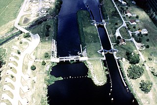
The St. Lucie Canal, also known as the C-44 Canal or simply C-44, is a man-made canal in Martin County, Florida, connecting Lake Okeechobee to the Indian River Lagoon. The canal was built between 1916 and 1924 to divert floodwaters from the lake into the St. Lucie Estuary via the South Fork of the St. Lucie River. Deepend in 1937 to enable the passage of boats, the St. Lucie Canal is now the eastern segment of the Okeechobee Waterway.

References

See also