A midden is an old dump for domestic waste which may consist of animal bone, human excrement, botanical material, mollusc shells, potsherds, lithics, and other artifacts and ecofacts associated with past human occupation.

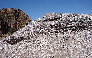
Crystal River State Archaeological Site is a 61-acre (250,000 m2) Florida State Park located on the Crystal River and within the Crystal River Preserve State Park. The park is located two miles (3 km) northwest of the city of Crystal River, on Museum Point off U.S. 19/98.

The Kolomoki Mounds is one of the largest and earliest Woodland period earthwork mound complexes in the Southeastern United States and is the largest in Georgia. Constructed from 350CE to 600CE, the mound complex is located in southwest Georgia, in present-day Early County near the Chattahoochee River.

Horr's Island is a significant Archaic period archaeological site located on an island in Southwest Florida formerly known as Horr's Island. Horr's Island is on the south side of Marco Island in Collier County, Florida. The site includes four mounds and a shell ring. It has one of the oldest known mound burials in the eastern United States, dating to about 3400 radiocarbon years Before Present (BP). One of the mounds has been dated to as early as 6700 BP. It was the largest known community in the southeastern United States to have been permanently occupied during the Archaic period.

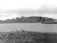
The Madira Bickel Mound State Archaeological Site is an archaeological site on Terra Ceia Island in northwestern Palmetto, Florida, United States. It is located on Bayshore Drive, west of U.S. 19, a mile south of I-275. On August 12, 1970, it was added to the U.S. National Register of Historic Places. It is also a Florida State Park.
Mound Key Archaeological State Park is a Florida State Park, located in Estero Bay, near the mouth of the Estero River. One hundred and thirteen of the island's one hundred and twenty-five acres are managed by the park system. It is a complex of mounds and accumulated shell, fish bone, and pottery middens that rises more than 30 feet above the waters of the bay.
The Garden Patch is a Middle Woodland archaeological site in Horseshoe Cove, near Horseshoe Beach, Florida, off County Road 351. For a major part of its occupation, the site was a ceremonial center associated with the Swift Creek and Weeden Island cultures. On April 25, 1991, it was added to the U.S. National Register of Historic Places.

The Safety Harbor Site is an archaeological site in Philippe Park at 2525 Philippe Parkway in Safety Harbor, Florida, United States. It is the type site for the Safety Harbor culture, and includes the largest remaining mound in the Tampa Bay area. It was designated a National Historic Landmark in 1964.

The St. Johns culture was an archaeological culture in northeastern Florida, USA that lasted from about 500 BCE until shortly after European contact in the 17th century. The St. Johns culture was present along the St. Johns River and its tributaries (including the Oklawaha River, and along the Atlantic coast of Florida from the mouth of the St. Johns River south to a point east of the head of the St. Johns River, near present-day Cocoa Beach, Florida. At the time of first European contact, the St. Johns culture area was inhabited by speakers of the Mocama, Agua Fresca and Acuera dialects of the Timucua language and by the Mayacas.

The Amalik Bay Archeological District is a geographic area with a significant number of archaeological sites in Alaska. It is located on the Pacific coast of Katmai National Park and Preserve, in the mainland portion of Kodiak Island Borough, Alaska.
The Chaluka Site is a prehistoric archaeological site and National Historic Landmark in Nikolski, Alaska, on Umnak Island in the Aleutian Islands of southwestern Alaska. The site documents more than 4,000 years of more-or-less continuous occupation of the area now occupied by the modern village of Nikolski. The site includes a large midden, yielding much information about the origins of the Aleut people.

Yukon Island is an island in outer Kachemak Bay, an inlet of the Cook Inlet of south central Alaska. The island is located about 9 miles (14 km) south of Homer. The island is archaeologically sensitive, with a number of sites documenting the prehistory of the bay. The Yukon Island Main Site, a National Historic Landmark, is a major shell midden site at which the pioneering archaeologist Frederica de Laguna was able to sequence 1500 years of the area's prehistory, and other sites have been found on the island since then. The island is now home to an educational retreat center.
The Safety Harbor culture was an archaeological culture practiced by Native Americans living on the central Gulf coast of the Florida peninsula, from about 900 CE until after 1700. The Safety Harbor culture is defined by the presence of Safety Harbor ceramics in burial mounds. The culture is named after the Safety Harbor Site, which is close to the center of the culture area. The Safety Harbor Site is the probable location of the chief town of the Tocobaga, the best known of the groups practicing the Safety Harbor culture.

Frogmore Mound Site is an archaeological site of the Late Coles Creek culture in Concordia Parish, Louisiana. The site is located 7 miles (11 km) west of Ferriday on US 84. It was added to the National Register of Historic Places on July 28, 2004.

The Mayberry Mound and Village Site are a valuable archaeological site in the southeastern portion of the U.S. state of Illinois. Located near the village of Sims in southern Wayne County, the site comprises what was once a substantial village during the Archaic period, and it has been designated a historic site because of its archaeological importance.
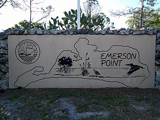
Emerson Point Preserve is a 365-acre (1.48 km2) preserve in Manatee County, Florida, located west of Palmetto and at the western end of Snead Island.
Takli Island is an island off the southern coast of the Alaska Peninsula in the Shelikof Strait of southwestern Alaska. It is located at the mouth of Amalik Bay, off the mainland portion of Kodiak Island Borough, in Katmai National Park and Preserve. The area was first archaeologically investigated in the 1960s, when the prehistory of the area was little known, and the island's sites are type sites for a series of archaeological cultures.

The Kukak Village Site is a prehistoric and historic archaeological site, located on the shore of Kukak Bay, on the south coast of the Alaska Peninsula in Katmai National Park and Preserve. The area was documented to be occupied in the early 20th century, and was abandoned after the 1912 volcanic eruption of Novarupta. The Kukak Bay area is also of prehistoric significance, with researchers identifying 89 depressions as likely sites of subterranean houses, and a refuse midden.
KOD-171 is a prehistoric and historic archaeological site in the vicinity of Larsen Bay, a city on the north side of Kodiak Island in southern Alaska. The site was discovered by Smithsonian Institution archaeologist Aleš Hrdlička and described in 1944 as containing both historical Russian artifacts as well as prehistoric Kachemak Bay tradition artifacts. A 1978 survey team reported the site to include 22 house pits and an eroding shell midden. The site, listed on the National Register of Historic Places in 1981, is subject to erosion and vandalism by pot hunters.
The Smuggler Cove Shell Midden is an archeological site located in Oswald West State Park near Neahkahnie Beach, Oregon, United States. First documented by archeologists in 1976, the midden has been found to contain remains of mussels, barnacles, and chiton to a depth of approximately 30 centimeters (12 in). Radiocarbon dating of a single sample of shell debris indicates that the Smuggler Cove campsite was occupied around 1660 CE, approximately the same date as the supposed wreck of a European ship at nearby Nehalem Spit, suggesting the site may preserve information from both before and after first contact between local people and Europeans. The site has been heavily damaged by construction of recreational facilities and coastal erosion, but a significant portion remains with potential to contribute to future research. Data generated from the site may help answer questions related to environmental change in the Oregon Coast region, settlement and subsistence patterns, emergence of ethnographic patterns among coastal people, the change in cultural patterns from before to after contact with European Americans, and other topics.


