Angel Mounds State Historic Site, an expression of the Mississippian culture, is an archaeological site managed by the Indiana State Museum and Historic Sites that includes more than 600 acres of land about 8 miles (13 km) southeast of present-day Evansville, in Vanderburgh and Warrick counties in Indiana. The large residential and agricultural community was constructed and inhabited from AD 1100 to AD 1450, and served as the political, cultural, and economic center of the Angel chiefdom. It extended within 120 miles (190 km) of the Ohio River valley to the Green River in present-day Kentucky. The town had as many as 1,000 inhabitants at its peak, and included a complex of thirteen earthen mounds, hundreds of home sites, a palisade (stockade), and other structures.

The Grand Village of the Illinois, also called Old Kaskaskia Village, is a site significant for being the best documented historic Native American village in the Illinois River valley. It was a large agricultural and trading village of Native Americans of the Illinois confederacy, located on the north bank of the Illinois River near the present town of Utica, Illinois. French explorers Louis Joliet and Father Jacques Marquette came across it in 1673. The Kaskaskia, a tribe of the Illiniwek people lived in the village. It grew rapidly after a mission and fur trading post were established there in 1675, to a population of about 6,000 people in about 460 houses. Around 1691 the Kaskaskia and other Illiniwek moved further south, abandoning the site due to pressure from an Iroquois invasion from the northeast.
The Angel Phase describes a 300-400-year cultural manifestation of the Mississippian culture of the central portions of the United States of America, as defined in the discipline of archaeology. Angel Phase archaeological sites date from c. 1050 - 1350 CE and are located on the northern and southern sides of the Ohio River in southern Indiana, such as National Historic Landmark Angel Mounds near present-day Evansville; northwestern Kentucky, with Wickliffe Mounds and the Tolu Site; and Kincaid Mounds State Historic Site in Illinois. Additional sites range from the mouth of Anderson River in Perry County, Indiana, west to the mouth of the Wabash in Posey County, Indiana.
The Stoner Site is a substantial archaeological site in the far eastern portion of the U.S. state of Illinois. Discovered during the Great Depression, the site has produced large numbers of artifacts from a prehistoric village that was once located there, and archaeological investigations have shown it to be one of the area's most important archaeological sites for the Allison-Lamotte culture. After more than a decade of fruitful research and predictions of potentially rich results from future work, it has been designated a historic site.

The Kincaid Mounds Historic Site c. 1050–1400 CE, is a Mississippian culture archaeological site located at the southern tip of present-day U.S. state of Illinois, along the Ohio River. Kincaid Mounds has been notable for both its significant role in native North American prehistory and for the central role the site has played in the development of modern archaeological techniques. The site had at least 11 substructure platform mounds, and 8 other monuments.

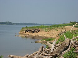
The Ashworth Archaeological Site is a significant archaeological site in the extreme southwestern corner of the U.S. state of Indiana. Located near the confluence of the Ohio and Wabash Rivers, it lies near several similar archaeological sites. It was first examined by archaeologists in the middle of the twentieth century and found to be the site of a relatively recent Native American village, and it has been designated a historic site because of its archaeological value.
The Mann Site is a Crab Orchard culture site located off Indian Mound Road in Mount Vernon, Posey County, Indiana. It was placed on the National Historic Register on October 1, 1974. Exotic ceramics and other artifacts found at the site reflect contact with Ohio Hopewell and Swift Creek culture people of the Georgia Piedmont and Gulf Coastal Plain.

The Juntunen Site, also known as 20MK1, is a stratified Prehistoric Late Woodland fishing village located on the western tip of Bois Blanc Island. It was listed on the National Register of Historic Places in 1978.

The Duffy Site is a substantial archaeological site along the Wabash River in the southeastern part of the U.S. state of Illinois. Located near the village of New Haven in Gallatin County, it is the type site for the Duffy Complex, a group of similar sites on the Illinois side of the Wabash near its confluence with the Ohio River. Duffy is distinctive largely because of its pottery: the site's inhabitants typically produced ceramics of various thicknesses and comparatively few decorative elements, tempered with grog. What decorations exist are typically limited to one or two rows of simple lines or bars that have been incised or stamped on the side of the piece of pottery. Projectile points found at the site are small triangular "Mounds Stemless" points, and the inhabitants produced celts of a vaguely rectangular shape. The site is believed to have been inhabited circa AD 1000.

The Ellerbusch Site (12-W-56) is a small but significant archaeological site in the southwestern part of the U.S. state of Indiana. Unlike many sites created by people of the same culture, it occupies an upland site near a major river floodplain. Its existence appears to have been the result of the coincidence of periods of peace and growth in the related Angel Site, which led some townspeople to leave their homes for new villages that were more convenient for resource gathering. Researched partly because of its small size, Ellerbusch has produced information that greatly increases present awareness of other small sites and of its culture's overall patterns of settlement in the region. Because of its archaeological value, the site was declared a historic site in the late twentieth century.

The Hubele Mounds and Village Site are an archaeological site in the southeastern part of the U.S. state of Illinois. Located near the community of Maunie in White County, the site has received recognition from the federal government because of its archaeological value. Due to the lack of recent excavations, the site's dates of habitation are debated, ranging from 400 BC in some estimates to AD 1000 in others, but all agree on the site's significance to understanding the prehistory of the region.

The White Site is a prehistoric archaeological site located northeast of Hickman in Fulton County in the southwestern corner of the U.S. state of Kentucky. Discovered in the 1980s, it was occupied during a long period of time by peoples of multiple cultures, and it has been named a historic site.

The Moccasin Bluff Site is an archaeological site located along Red Bud Trail and the St. Joseph River north of Buchanan, Michigan. It was listed on the National Register of Historic Places in 1977, and has been classified as a multi-component Prehistoric site with the major component dating to the Late Woodland/Upper Mississippian period.

The Griesmer site (La-3) is located on the Kankakee River in Lake County, Indiana, about a mile southeast of Schneider, in Northwestern Indiana. It is classified as a Prehistoric, multi-component site with Middle Woodland, Late Woodland and Upper Mississippian occupations. The deposits were not stratified, but observation of the types of artifacts present, together with radiocarbon dates, helped to define the sequence of occupations at the site.
The Fifield site (Pr-55) is located on Damon Run Creek in Porter County, northwestern Indiana. It is classified as a late Prehistoric, single-component Upper Mississippian Fisher village.

The Knoll Spring site (11Ck-19), aka Au Sagaunashke Village, is located in the Sag Valley, Palos Hills, in Cook County, Illinois, near the city of Chicago. It is classified as a late Prehistoric site with Upper Mississippian Huber affiliation.
The Hotel Plaza Site (Ls-36) is located near Starved Rock, on the Illinois River across from the Zimmerman Site (aka Grand Village of the Illinois. It is a multi-component site representing Prehistoric, Protohistoric and early Historic periods, with the main occupation being an early Historic component associated with the French Fort St. Louis.

The Plum Island Site (Ls-2) is located in the Illinois River near Starved Rock, LaSalle County, Illinois, in the vicinity of the Hotel Plaza site and the Zimmerman site. It is a multi-component site representing Prehistoric, Protohistoric and early Historic periods, with the main occupation being a late Prehistoric to early Historic component with Upper Mississippian affiliation.

The Carcajou Point Site is located in Jefferson County, Wisconsin, on Lake Koshkonong. It is a multi-component site with Prehistoric Upper Mississippian Oneota and Historic components.
![Walker-Hooper Site Archaeological site in [[Wisconsin]], United States](https://upload.wikimedia.org/wikipedia/en/thumb/f/f9/Walker-Hooper_Site.jpeg/320px-Walker-Hooper_Site.jpeg)
The Walker-Hooper Site (47-GL-65) is a multicomponent Prehistoric site complex located on the Grand River in the Upper Fox River drainage area in Green Lake County, Wisconsin. It consisted of at least 2 village sites and several mound groups. It was excavated by S.A. Barrett under the auspices of the Milwaukee Public Museum in 1921 and again in 1967 by Guy Gibbon of the University of Wisconsin-Milwaukee. The major component of the site is an Upper Mississippian Oneota palisaded village. Other components were also present, mainly Late Woodland but also including Archaic, Early Woodland and Middle Woodland.