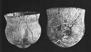
Wickliffe Mounds is a prehistoric, Mississippian culture archaeological site located in Ballard County, Kentucky, just outside the town of Wickliffe, about 3 miles (4.8 km) from the confluence of the Ohio and Mississippi rivers. Archaeological investigations have linked the site with others along the Ohio River in Illinois and Kentucky as part of the Angel Phase of Mississippian culture. Wickliffe Mounds is controlled by the State Parks Service, which operates a museum at the site for interpretation of the ancient community. Listed on the National Register of Historic Places, it is also a Kentucky Archeological Landmark and State Historic Site.

Hopewell Culture National Historical Park is a United States national historical park with earthworks and burial mounds from the Hopewell culture, indigenous peoples who flourished from about 200 BC to AD 500. The park is composed of six separate sites in Ross County, Ohio, including the former Mound City Group National Monument. The park includes archaeological resources of the Hopewell culture. It is administered by the United States Department of the Interior's National Park Service.

Mounds State Park is a state park near Anderson, Madison County, Indiana featuring Native American heritage, and ten ceremonial mounds built by the prehistoric Adena culture indigenous peoples of eastern North America, and also used centuries later by Hopewell culture inhabitants. It is separate from the similarly named Mounds State Recreation Area. The park receives about 400,000 visitors annually.

The Kolomoki Mounds is one of the largest and earliest Woodland period earthwork mound complexes in the Southeastern United States and is the largest in Georgia. Constructed from 350CE to 600CE, the mound complex is located in southwest Georgia, in present-day Early County near the Chattahoochee River.

The Toolesboro Mound Group, a National Historic Landmark, is a group of Havana Hopewell culture earthworks on the north bank of the Iowa River near its discharge into the Mississippi. The mounds are owned and displayed to the public by the State Historical Society of Iowa. The mound group is located east of Wapello, Iowa, near the unincorporated community of Toolesboro.

The Naples Mound 8 is a Havana Hopewell culture mound site located in Pike County, Illinois three miles east of the city of Griggsville. The mound was given the name Naples Mound #8 in 1882. The mound was listed on the National Register of Historic Places in 1975.

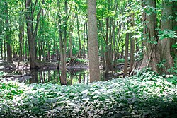
Channahon State Park is an Illinois state park in Will County, Illinois, United States. The park was named after a Native American word meaning "the meeting of the waters". It lies adjacent to the confluence of the Dupage, Des Plaines, and Kankakee Rivers.

The Mathew Mound is a Native American mound in the southwestern part of the U.S. state of Ohio. Located off Oak Road near the village of Evendale, the mound is believed to have been built by members of the Adena or Hopewell peoples during the Woodland period.

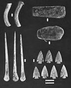
The Kincaid Mounds Historic Site c. 1050–1400 CE, is a Mississippian culture archaeological site located at the southern tip of present-day U.S. state of Illinois, along the Ohio River. Kincaid Mounds has been notable for both its significant role in native North American prehistory and for the central role the site has played in the development of modern archaeological techniques. The site had at least 11 substructure platform mounds, and 8 other monuments.

Leary Site, also known as 25-RH-1 or Leary-Kelly Site is an archaeological site near Rulo, Nebraska and the Big Nemaha River. The site now lies entirely on the reservation of the Iowa Tribe of Kansas and Nebraska. The area was once a village and burial site.

The Goodall Focus was a Hopewellian culture from the Middle Woodland period peoples that occupied Western Michigan and northern Indiana from around 200 BCE to 500 CE. Extensive trade networks existed at this time, particularly among the many local cultural expressions of the Hopewell communities. The Goodall pattern stretched from the southern tip of Lake Michigan, east across northern Indiana, to the Ohio border, then northward, covering central Michigan, almost reaching to Saginaw Bay on the east and Grand Traverse Bay to the north. The culture is named for the Goodall Site in northwest Indiana.
The Boyd Mounds Site (22MD512) is an archaeological site from the Late Woodland and Early Mississippian period located in Madison County, Mississippi near Ridgeland. Many of the mounds were excavated by The National Park Service in 1964. It is located at mile 106.9 on the old Natchez Trace, now the Natchez Trace Parkway. It was added to the NRHP on July 14, 1989 as NRIS number 89000784.
Pharr Mounds is a Middle Woodland period archaeological site located near Tupelo in parts of Itawamba and Prentiss counties in northern Mississippi. This complex was made of earthwork mounds.

The Bynum Mound and Village Site (22CS501) is a Middle Woodland period archaeological site located near Houston in Chickasaw County, Mississippi. The complex of six burial mounds was in use during the Miller 1 and Miller 2 phases of the Miller culture and was built between 100 BC and 100 AD. It was listed on the National Register of Historic Places in 1989 as part of the Natchez Trace Parkway at milepost 232.4.

Fewkes Group Archaeological Site, also known as the Boiling Springs Site, is a pre American history Native American archaeological site located in the city of Brentwood, in Williamson County, Tennessee. It is in Primm Historic Park on the grounds of Boiling Spring Academy, a historic schoolhouse established in 1830. The 15-acre site consists of the remains of a late Mississippian culture mound complex and village roughly dating to 1050-1475 AD. The site, which sits on the western bank of the Little Harpeth River, has five mounds, some used for burial and others, including the largest, were ceremonial platform mounds. The village was abandoned for unknown reasons around 1450. The site is named in honor of Dr. J. Walter Fewkes, the Chief of the Bureau of American Ethnology in 1920, who had visited the site and recognized its potential. While it was partially excavated by the landowner in 1895, archaeologist William E. Myer directed a second, more thorough excavation in October 1920. The report of his findings was published in the Bureau of American Ethnology's Forty-First Annual Report. Many of the artifacts recovered from the site are now housed at the Smithsonian Institution. It was added to the National Register of Historic Places on April 21, 1980, as NRIS number 80003880.

The Younge Site is an archeological site located in Goodland Township, Lapeer County, Michigan. It is classified as a Prehistoric Late Woodland site and was designated as a Michigan State Historic Site on October 29, 1971. It was added to the National Register of Historic Places on October 29, 1976.

The Spoonville site, also designated 20OT1, is a historic archeological site, located on the banks of the Grand River in Crockery Township, Ottawa County, Michigan, United States. It was placed on the National Register of Historic Places in 1973.
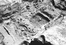
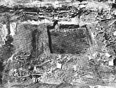
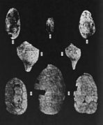
The Fisher Mound Group is a group of burial mounds with an associated village site located on the DesPlaines River near its convergence with the Kankakee River where they combine to form the Illinois River, in Will County, Illinois, about 60 miles southwest of Chicago. It is a multi-component stratified site representing several Prehistoric Upper Mississippian occupations as well as minor Late Woodland and Early Historic components.