Pharr Mounds

Last updated

Pharr Mounds
Pharr Mounds.jpg
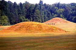
Two mounds at the Pharr Mounds site
USA Mississippi location map.svg
Red pog.svg
Nearest city Tupelo, Mississippi
Coordinates 34°27′59.3562″N88°25′0.1734″W / 34.466487833°N 88.416714833°W / 34.466487833; -88.416714833
NRHP reference No. 78000346 [1]
Added to NRHPFebruary 23, 1978 [1]

Pharr Mounds is a Middle Woodland period archaeological site located near Tupelo in parts of Itawamba and Prentiss counties in northern Mississippi. This complex was made of earthwork mounds.

Contents

The complex of eight dome-shaped, tumulus burial mounds was in use during the Miller 1 phase of the Miller culture. [2] These were constructed as earthwork mounds between 1 and 200 CE. The complex is considered to be one of the largest and most important sites from this era. [3] It was listed on the National Register of Historic Places in 1978 as part of the Natchez Trace Parkway at milepost 286.7. [1]

Site description

The site is located at the headwaters of the Tombigbee River, a rugged, hilly area with many broad, swampy streams. It is named for "Pharr Flats", a wide, gently rolling terrace overlooking the confluence of Little Brown and Mackeys creeks. The site features eight dome-shaped mounds of differing sizes, several of which have been nearly flattened by plowing and cultivation during European-American farming. The mounds in the Pharr Mounds site are found over an area of 90 acres of land. [4]

Pharr Mounds 1.JPG
Pharr Mounds site
MoundWidth and lengthHeight
Mound A55 feet (17 m) by 65 feet (20 m)7 feet (2.1 m)
Mound B105 feet (32 m) by 110 feet (34 m)18 feet (5.5 m)
Mound C115 feet (35 m) in diameter18 feet (5.5 m)
Mound D80 feet (24 m) by 95 feet (29 m)12 feet (3.7 m)
Mound E165 feet (50 m) by 175 feet (53 m)8 feet (2.4 m)
Mound F60 feet (18 m) in diameter8 feet (2.4 m)
Mound G200 feet (61 m) in diameter6 feet (1.8 m)
Mound H110 feet (34 m) by 130 feet (40 m)2 feet (0.61 m)

[4]

Diagram of Pharr Mounds Pharr Mounds diagram HRoe 2010.jpg
Diagram of Pharr Mounds

Archaeology

In 1966 Charles Bohannon, an archaeologist for the National Park Service, supervised [5] an excavation of four of the mounds. The excavators found fire pits and low clay platforms at the base of the mounds. [3] They also found human remains, some cremated, as well as various ceremonial artifacts.

Many of the artifacts were made from non-local materials, such as Great Lakes copper and greenstone, galena, and mica, demonstrating the reach of trading through the Hopewell exchange system. These artifacts, which include copper ear-spools and a greenstone platform pipe, show the connection of the local peoples with the larger Middle Woodland period world of the time, reaching to the Great Lakes. [3]

See also

References

  1. 1 2 3 "National Register of Historic Places". National Park Service. November 16, 2010.
  2. "Pharr Mounds-Ceramic analysis". National Park Service. Archived from the original on July 14, 2010. Retrieved November 16, 2010.
  3. 1 2 3 "Pharr Mounds-National Register of Historic Places Indian Mounds of Mississippi Travel Itinerary". National Park Service. Archived from the original on February 25, 2009. Retrieved November 16, 2010.
  4. 1 2 "Pharr Mounds-The site and its setting". National Park Service. Archived from the original on July 14, 2010. Retrieved November 16, 2010.
  5. Excavation at the Pharr Mounds, US Department of Interior. July, 1972