Tupelo National Battlefield

Last updated

Tupelo National Battlefield
Tupelo NBS Monument.jpg
Battle of Tupelo Memorial, 2006
Location Tupelo, Mississippi,
United States
Coordinates 34°15′20.4″N88°44′13.2″W / 34.255667°N 88.737000°W / 34.255667; -88.737000
Area1 acre (0.40 ha) [1]
EstablishedFebruary 21, 1929 (1929-02-21) (War Dept.)
August 10, 1933 (NPS) [2]
Governing body National Park Service
Website Tupelo National Battlefield
DesignatedOctober 15, 1966 (1966-10-15)
Reference no.66000068
USA Mississippi location map.svg
Red pog.svg
Map of Mississippi
Usa edcp location map.svg
Red pog.svg
Tupelo National Battlefield (the United States)

Tupelo National Battlefield commemorates the Battle of Tupelo, also known as the Battle of Harrisburg, fought from July 14 to 15, 1864, near Tupelo, Mississippi during the American Civil War. The Union victory over Confederate forces in northeast Mississippi ensured the safety of Sherman's supply lines during the Atlanta Campaign. [3]

Contents

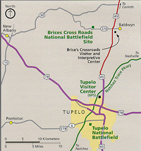
The 1-acre site on Main Street in Tupelo is a grassy park with a flagpole, memorial monument, and two cannons. There are no visitor services; information is provided at the visitor center for the Natchez Trace Parkway six miles north. The monument and site are very similar to that at Brices Cross Roads National Battlefield Site.

Administrative history

Tupelo area National Park Service map USA Mississippi Tupelo area NPS map.jpg
Tupelo area National Park Service map

The Tupelo National Battlefield was established as "Tupelo Battlefield Site" on February 21, 1929. The site was transferred from the United States War Department to the National Park Service on August 10, 1933, redesignated, and boundary changed on August 10, 1961. In 1936, the Tupelo-Gainesville Tornado destroyed the concrete monument to the battle, ripping it out of the ground and shattering it. [4] The site was listed in the National Register of Historic Places on October 15, 1966.

See also

Notes

  1. "Listing of acreage – December 31, 2020" (XLSX). Land Resource Division, National Park Service. Retrieved August 15, 2021. (National Park Service Acreage Reports)
  2. "Park Anniversaries" . Retrieved August 13, 2021.
  3. Bearss 1971, p. 1.
  4. National Park Service 2001, p. 57.

Related Research Articles

<span class="mw-page-title-main">Battle of Brice's Cross Roads</span> 1864 battle of the American Civil War

The Battle of Brice's Cross Roads, also known as the Battle of Tishomingo Creek or the Battle of Guntown, was fought on Friday, June 10, 1864, near Baldwyn, Mississippi, then part of the Confederate States of America. A Federal expedition from Memphis, Tennessee, of 4,800 infantry and 3,300 cavalry, under the command of Brigadier-General Samuel D. Sturgis, was defeated by a Confederate force of 3,500 cavalry under the command of Major-General Nathan B. Forrest. The battle was a victory for the Confederates. Forrest inflicted heavy casualties on the Federal force and captured more than 1,600 prisoners of war, 18 artillery pieces, and wagons loaded with supplies. Once Sturgis reached Memphis, he asked to be relieved of his command.

<span class="mw-page-title-main">Lee County, Mississippi</span> County in Mississippi, United States

Lee County is a county in U.S. state of Mississippi. At the 2020 census, the population was 83,343. Its county seat is Tupelo. Lee County is included in the Tupelo Micropolitan Statistical Area.

<span class="mw-page-title-main">Tupelo, Mississippi</span> City in Mississippi, United States

Tupelo is a city in and the county seat of Lee County, Mississippi, United States. Founded in 1860, the population was 37,923 at the 2020 census. It is the 7th most populous city in Mississippi and is considered a commercial, industrial, and cultural hub of northern Mississippi.

<span class="mw-page-title-main">Natchez Trace Parkway</span> National parkway in the southeastern U.S.

The Natchez Trace Parkway is a limited-access national parkway in the Southeastern United States that commemorates the historic Natchez Trace and preserves sections of that original trail. Its central feature is a two-lane road that extends 444 miles (715 km) from Natchez, Mississippi, to Nashville, Tennessee. Access to the parkway is limited, with more than 50 access points in Mississippi, Alabama, and Tennessee. The southern end of the route is in Natchez at its intersection with Liberty Road, and the northern end is northeast of Fairview, Tennessee, in the suburban community of Pasquo, at an intersection with Tennessee State Route 100. In addition to Natchez and Nashville, larger cities along the route include Jackson and Tupelo, Mississippi, and Florence, Alabama.

<span class="mw-page-title-main">Kennesaw Mountain National Battlefield Park</span> Public park and historic Civil War location in Georgia

Kennesaw Battlefield Park preserves a Civil War battleground of the Atlanta Campaign, and also contains Kennesaw Mountain. It is located at 900 Kennesaw Mountain Drive, between Marietta and Kennesaw, Georgia. The name "Kennesaw" derives from the Cherokee Indian "Gah-nee-sah" meaning "cemetery" or burial ground. The area was designated as a U.S. historic district on October 15, 1966.

Monocacy National Battlefield is a unit of the National Park Service, the site of the Battle of Monocacy in the American Civil War fought on July 9, 1864. The battlefield straddles the Monocacy River southeast of the city of Frederick, Maryland. The battle, labeled "The Battle That Saved Washington," was one of the last the Confederates would carry out in Union territory. The two opposing leaders were General Jubal Early, fighting for the South, and General Lew Wallace, fighting for the North.

<span class="mw-page-title-main">Shiloh National Military Park</span> Historic Civil War site in Hardin County, Tennessee

Shiloh National Military Park preserves the American Civil War Shiloh and Corinth battlefields. The main section of the park is in the unincorporated community of Shiloh, about nine miles (14 km) south of Savannah, Tennessee, with additional areas located in the city of Corinth, Mississippi, 23 miles (37 km) southwest of Shiloh and the Parker's Crossroads Battlefield in the city of Parkers Crossroads, Tennessee. The Battle of Shiloh began a six-month struggle for the key railroad junction at Corinth. Afterward, Union forces marched from Pittsburg Landing to take Corinth in a May siege, then withstood an October Confederate counter-attack.

<span class="mw-page-title-main">National military park</span> Military Parks of the United States

National Military Park, National Battlefield, National Battlefield Park, and National Battlefield Site are four designations for 25 battle sites preserved by the United States federal government because of their national importance. The designation applies to "sites where historic battles were fought on American soil during the armed conflicts that shaped the growth and development of the United States...."

<span class="mw-page-title-main">Ed Bearss</span> American military veteran and historian (1923–2020)

Edwin Cole Bearss was a historian of the American Civil War, tour guide, and United States Marine Corps veteran of World War II.

<span class="mw-page-title-main">Brices Cross Roads National Battlefield Site</span> Battlefield in Mississippi, United States

Brices Cross Roads National Battlefield Site memorializes the Battle of Brice's Cross Roads, in which a U.S. Army force was defeated by a smaller Confederate force commanded by Major-General Nathan Bedford Forrest on June 10, 1864, but nonetheless secured Union supply lines between Nashville and Chattanooga, Tennessee.

<span class="mw-page-title-main">Wilson's Creek National Battlefield</span> National battlefield in Missouri, United States

Wilson's Creek National Battlefield, located near Republic, Missouri, preserves the site of the Battle of Wilson's Creek. Fought on August 10, 1861, the battle was the first major American Civil War engagement west of the Mississippi River. In the battle, a Confederate army commanded by Benjamin McCulloch and Sterling Price defeated a smaller Union army commanded by Nathaniel Lyon. However, the Confederates were unable to hold much of Missouri, and a Confederate defeat at the Battle of Pea Ridge effectively solidified Union control of the state. Major features include a five-mile automobile tour loop, the restored 1852 Ray House, and "Bloody Hill", the site of the final stage of the battle. The site is located near Republic in southwestern Missouri just southwest of the city of Springfield. It has been a unit of the National Park Service since 1960, and was listed on the National Register of Historic Places in 1966.

<span class="mw-page-title-main">Manassas National Battlefield Park</span> Battlefield in Virginia, USA

Manassas National Battlefield Park is a unit of the National Park Service located in Prince William County, Virginia, north of Manassas that preserves the site of two major American Civil War battles: the First Battle of Bull Run, also called the Battle of First Manassas, and the Second Battle of Bull Run or Battle of Second Manassas. It was also where Confederate General Thomas J. Jackson acquired his nickname "Stonewall". The park was established in 1936 and listed on the National Register of Historic Places on October 15, 1966.

<span class="mw-page-title-main">Battle of Raymond</span> 1863 battle of the American Civil War

The Battle of Raymond was fought on May 12, 1863, near Raymond, Mississippi, during the Vicksburg campaign of the American Civil War. Initial Union attempts to capture the strategically important Mississippi River city of Vicksburg failed. Beginning in late April 1863, Union Major General Ulysses S. Grant led another try. After crossing the river into Mississippi and winning the Battle of Port Gibson, Grant began moving east, intending to turn back west and attack Vicksburg. A portion of Grant's army consisting of Major General James B. McPherson's 10,000 to 12,000-man XVII Corps moved northeast towards Raymond. The Confederate commander of Vicksburg, Lieutenant General John C. Pemberton, ordered Brigadier General John Gregg and his 3,000 to 4,000-strong brigade from Jackson to Raymond.

The Battle of Tupelo, also known as the Battle of Harrisburg, was a battle of the American Civil War fought July 14–15, 1864, near Tupelo, Mississippi. The Union victory over Confederate forces in north Mississippi ensured the safety of Sherman's supply lines during the Atlanta Campaign.

The 95th Regiment Illinois Volunteer Infantry was an infantry regiment that served in the Union Army during the American Civil War.

<span class="mw-page-title-main">Marks' Mills Battleground State Park</span> Battlefield in Arkansas, United States

Marks' Mills Battleground State Park is an Arkansas State Park located at the junction of Arkansas Highway 8 and Arkansas Highway 97, north of New Edinburg, Arkansas. It preserves a portion of the battlefield of the Battle of Marks' Mills fought on April 25, 1864, in the Trans-Mississippi Theater of American Civil War. The battle was part of the Camden Expedition. The park is one of nine historic sites that make up the Camden Expedition Sites, a National Historic Landmark District. The battle was most known for the slaughter of black Union soldiers that were murdered as they tried to surrender.

<span class="mw-page-title-main">114th Illinois Infantry Regiment</span> Military unit

The 114th Illinois Infantry Regiment was an infantry regiment from Illinois that served in the Union Army during the American Civil War. Formed in September 1862, the regiment served in Ulysses S. Grant's Central Mississippi campaign, in the Vicksburg campaign, at Brices Cross Roads, at Tupelo, in the 1864 Missouri campaign, at Nashville, and at Spanish Fort. At Nashville, the unit participated in the decisive attack on Shy's Hill. In 1865, the regiment was reassigned as pontoniers. The regiment was mustered out in August 1865.

<span class="mw-page-title-main">Old Natchez Trace segments listed on the National Register of Historic Places</span> United States historic place

Seven segments of the historic Natchez Trace are listed on the National Register of Historic Places (NRHP). Also there are additional NRHP-listed structures and other sites along the Natchez Trace, which served the travelers of the trace and survive from the era of its active use.

The Civil War Trust's Civil War Discovery Trail is a heritage tourism program that links more than 600 U.S. Civil War sites in more than 30 states. The program is one of the White House Millennium Council's sixteen flagship National Millennium Trails. Sites on the trail include battlefields, museums, historic sites, forts and cemeteries.

<span class="mw-page-title-main">Battery G, 2nd Illinois Light Artillery Regiment</span> Military unit

Battery G, 2nd Illinois Light Artillery Regiment was an artillery battery from Illinois that served in the Union Army during the American Civil War. The battery was organized at the end of December 1861. It fought at Vicksburg in 1863, Tupelo and Nashville in 1864, and Spanish Fort and Fort Blakeley in 1865. The battery was mustered out in September 1865.

References

Government
General information