Grand Bay National Estuarine Research Reserve

Last updated
Grand Bay National Estuarine Research Reserve

Aerial view of Grand Bay National Estuarine Research Reserve.jpg

Aerial view showing eroding shoreline along Rigolets
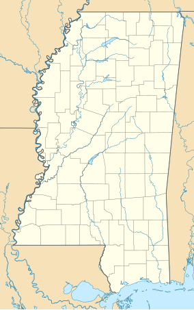
USA Mississippi location map.svg
Red pog.svg
Map of Mississippi
Location Mississippi, United States
Nearest city Pascagoula
Coordinates 30°22′38″N88°26′02″W / 30.3773°N 88.434°W / 30.3773; -88.434 Coordinates: 30°22′38″N88°26′02″W / 30.3773°N 88.434°W / 30.3773; -88.434
Area 18,400 acres (7,400 ha)
Established 1999
nerrs.noaa.gov/Reserve.aspx?ResID=GRD

The Grand Bay National Estuarine Research Reserve is one of the most biologically productive estuarine ecosystems in the Gulf of Mexico region, supporting several rare or endangered plant and animal species, numerous important marine fishery resources, diverse habitat types and archaeological sites, in the U.S. State of Mississippi.

Gulf of Mexico An Atlantic Ocean basin extending into southern North America

The Gulf of Mexico is an ocean basin and a marginal sea of the Atlantic Ocean, largely surrounded by the North American continent. It is bounded on the northeast, north and northwest by the Gulf Coast of the United States, on the southwest and south by Mexico, and on the southeast by Cuba. The U.S. states of Texas, Louisiana, Mississippi, Alabama, and Florida border the Gulf on the north, which are often referred to as the "Third Coast", in comparison with the U.S. Atlantic and Pacific coasts.

In biology, a species ( ) is the basic unit of classification and a taxonomic rank of an organism, as well as a unit of biodiversity. A species is often defined as the largest group of organisms in which any two individuals of the appropriate sexes or mating types can produce fertile offspring, typically by sexual reproduction. Other ways of defining species include their karyotype, DNA sequence, morphology, behaviour or ecological niche. In addition, paleontologists use the concept of the chronospecies since fossil reproduction cannot be examined. While these definitions may seem adequate, when looked at more closely they represent problematic species concepts. For example, the boundaries between closely related species become unclear with hybridisation, in a species complex of hundreds of similar microspecies, and in a ring species. Also, among organisms that reproduce only asexually, the concept of a reproductive species breaks down, and each clone is potentially a microspecies.

Fishery entity engaged in raising or harvesting fish which is determined by some authority to be a fishery

Generally, a fishery is an entity engaged in raising or harvesting fish which is determined by some authority to be a fishery. According to the FAO, a fishery is typically defined in terms of the "people involved, species or type of fish, area of water or seabed, method of fishing, class of boats, purpose of the activities or a combination of the foregoing features". The definition often includes a combination of fish and fishers in a region, the latter fishing for similar species with similar gear types.

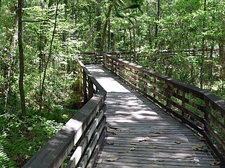
The reserve encompasses coastal bay, expansive saltwater marshes, maritime pine forest, pine savanna and pitcher plant bogs. It supports extensive and productive oyster reefs and seagrass habitats. It also serves as nursery area for many of the Gulf of Mexico's important recreational and commercial marine species, such as shrimp, blue crab, speckled trout, and red fish.

Pine genus of plants

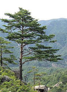
A pine is any conifer in the genus Pinus of the family Pinaceae. Pinus is the sole genus in the subfamily Pinoideae. The Plant List compiled by the Royal Botanic Gardens, Kew and Missouri Botanical Garden accepts 126 species names of pines as current, together with 35 unresolved species and many more synonyms.

Forest dense collection of trees covering a relatively large area

A forest is a large area dominated by trees. Hundreds of more precise definitions of forest are used throughout the world, incorporating factors such as tree density, tree height, land use, legal standing and ecological function. According to the widely used Food and Agriculture Organization definition, forests covered 4 billion hectares (9.9×10⁹ acres) (15 million square miles) or approximately 30 percent of the world's land area in 2006.

Savanna grassland ecosystem

A savanna or savannah is a mixed woodland grassland ecosystem characterised by the trees being sufficiently widely spaced so that the canopy does not close. The open canopy allows sufficient light to reach the ground to support an unbroken herbaceous layer consisting primarily of grasses.

As part of the Grand Bay Savannah Conservation Partnership, the Grand Bay Reserve is participating in a prescribed burn management program for the East Mississippi Sound Region. This project is widely supported by local and state government agencies as well as the oil and gas industry with facilities in adjacent fire-dependent woodlands.

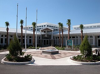
The Grand Bay Coastal Resources Center Interpretative Area is the headquarters for the Reserve and the Grand Bay National Wildlife Refuge. Completed in 2009, the Center features interpretive exhibits, classrooms, laboratories and a dormitory. Environmental education programs for and special events are offered. Visitor activities include hiking, boating, paddling, photography, fishing and hunting.

Grand Bay National Wildlife Refuge protected area

Grand Bay National Wildlife Refuge was established in 1992 under the Emergency Wetlands Resources Act of 1986 to protect one of the largest expanses of undisturbed pine savanna habitats in the Gulf Coastal Plain region. The refuge is located near Grand Bay, Alabama in Mobile County, Alabama and Jackson County, Mississippi, and when complete will encompass over 32,000 acres (130 km2). The refuge is part of the National Wildlife Refuge system. The Refuge Complex Manager also administers the Mississippi Sandhill Crane National Wildlife Refuge and Bon Secour National Wildlife Refuge. Access to refuge lands is limited, but is available mostly on the Mississippi side and by boat.

Related Research Articles

National Estuarine Research Reserve

The National Estuarine Research Reserve System is a network of 29 protected areas established by partnerships between the National Oceanic and Atmospheric Administration (NOAA) and coastal states. The reserves represent different biogeographic regions of the United States. The National Estuarine Research Reserve System protects more than 1.3 million acres of coastal and estuarine habitats for long-term research, water-quality monitoring, education, and coastal stewardship.

Coastal Zone Management Act

The Coastal Zone Management Act of 1972 is an Act of Congress passed in 1972 to encourage coastal states to develop and implement coastal zone management plans (CZMPs). This act was established as a United States National policy to preserve, protect, develop, and where possible, restore or enhance, the resources of the Nation's coastal zone for this and succeeding generations.

Apalachicola River 180 km (112mi) river in Florida, USA

The Apalachicola River is a river, approximately 112 mi (180 km) long in the state of Florida. The river's large watershed, known as the ACF River Basin, drains an area of approximately 19,500 square miles (50,505 km2) into the Gulf of Mexico. The distance to its farthest head waters in northeast Georgia is approximately 500 miles (800 km). Its name comes from the Apalachicola people, who used to live along the river.

The National Ocean Service (NOS), an office within the U.S. Department of Commerce National Oceanic and Atmospheric Administration (NOAA), is responsible for preserving and enhancing the nation’s coastal resources and ecosystems along 95,000 miles (153,000 km) of shoreline bordering 3,500,000 square miles (9,100,000 km2) of coastal, Great Lakes, and ocean waters. Its mission is to "provide science-based solutions through collaborative partnerships to address evolving economic, environmental, and social pressures on our oceans and coasts." NOS works closely with many partner agencies to ensure that ocean and coastal areas are safe, healthy, and productive. National Ocean Service scientists, natural resource managers, and specialists ensure safe and efficient marine transportation, promote innovative solutions to protect coastal communities, and conserve marine and coastal places. NOS is a scientific and technical organization of 1,700 scientists, natural resource managers, and specialists in many different fields. NOS delivers a dynamic range of nationwide coastal and Great Lakes scientific, technical, and resource management services in support of safe, healthy, and productive oceans and coasts. NOS develops partnerships to integrate expertise and efforts across all levels of government and with other interests to protect, maintain, and sustain the viability of coastal communities, economies and ecosystems.

Greater Farallones National Marine Sanctuary marine protected area in California, USA

The Greater Farallones National Marine Sanctuary protects the wildlife, habitats, and cultural resources of one of the most diverse and bountiful marine environments in the world, an area of 3,295 square miles off the northern and central California coast. The waters within Greater Farallones National Marine Sanctuary are part of a nationally significant marine ecosystem, and support an abundance of life, including many threatened or endangered species.

Monterey Bay National Marine Sanctuary marine protected area in California, USA

The Monterey Bay National Marine Sanctuary (MBNMS) is a US Federally protected marine area offshore of California's Big Sur and central coast. It is the largest US national marine sanctuary and has a shoreline length of 276 miles (444 km) stretching from just north of the Golden Gate Bridge at San Francisco to Cambria in San Luis Obispo County. Supporting one of the world’s most diverse marine ecosystems, it is home to numerous mammals, seabirds, fishes, invertebrates and plants in a remarkably productive coastal environment. The MBNMS was established in 1992 for the purpose of resource protection, research, education, and public use.

Mississippi River Delta plain

The Mississippi River Delta region is a three-million-acre area of land that stretches from Vermilion Bay on the west, to the Chandeleur Islands in the Gulf of Mexico on the southeastern coast of Louisiana. It is part of the Louisiana coastal plain, one of the largest areas of coastal wetlands in the United States. The Mississippi River Delta is the 7th largest river delta on Earth (USGS) and is an important coastal region for the United States, containing more than 2.7 million acres of coastal wetlands and 37% of the estuarine marsh in the conterminous U.S. The coastal area is the nation's largest drainage basin and drains about 41% of the contiguous United States into the Gulf of Mexico at an average rate of 470,000 cubic feet per second.

Wells National Estuarine Research Reserve

Wells National Estuarine Research Reserve, located in Wells, Maine, USA, is 2,250 acres (9.1 km2) of protected land headquartered at a restored saltwater farm called Laudholm. As a National Estuarine Research Reserve, the Wells Reserve works to expand knowledge of coasts and estuaries, engage people in environmental learning, and involve communities in conservation, all with a goal of protecting and restoring coastal ecosystems around the Gulf of Maine. Wells Reserve funding is largely through the National Oceanic and Atmospheric Administration and the nonprofit Laudholm Trust.

Wetlands of Louisiana

The wetlands of Louisiana are water-saturated coastal and swamp regions of southern Louisiana.

Golden Gate Biosphere Reserve nature reserve in northern California, USA

The Golden Gate Biosphere is a biosphere reserve in Northern California. It was created by UNESCO in 1988 and encompasses 13 protected areas in the San Francisco Bay Area. It extends through the central California coastal region from the Bodega Marine Reserve in the north to Jasper Ridge in the south and includes the Farallon Islands, Angel Island, and Alcatraz within the San Francisco Bay. The biosphere reserve is situated on both sides of the San Andreas Fault. Each side has a completely different type of bedrock, and the western side of the rift is moving northward. It encompasses a diverse range of marine, coastal, and upland habitats of the California chaparral and woodlands and Northern California coastal forests ecoregions, including mixed evergreen forests, Coast Redwood forests, Douglas-fir forests, Bishop pine forests, oak forests, woodlands and savannas, northern coastal scrub, chaparral, coastal dune, coastal strand, tidepools, kelp forests, coastal grasslands, and marshes. The associated fauna is also rich with cougars, Tule elk, California sea lions, elephant seals, and many shorebirds.

Jacques Cousteau National Estuarine Research Reserve

The Jacques Cousteau National Estuarine Research Reserve, located in southeastern New Jersey, encompasses over 110,000 acres (450 km²) of terrestrial, wetland and aquatic habitats within the Mullica River-Great Bay Ecosystem.

Rookery Bay Reserve protects 110,000 acres of coastal lands and waters at the northern end of the Ten Thousand Islands on the gulf coast of Florida, Rookery Bay National Estuarine Research Reserve represents one of the few remaining undisturbed mangrove estuaries in North America.

Guana Tolomato Matanzas National Estuarine Research Reserve protected area

In 1999, the Guana Tolomato Matanzas National Estuarine Research Reserve was designated in St. Johns and Flagler counties, Florida as a part of the National Oceanic and Atmospheric Administration (NOAA) National Estuarine Research Reserve (NERR) system. The GTM Research Reserve represents the east Florida sub-region of the Carolinian bioregion. It is one of 29 NERRs in 23 states and one territory. GTM is one of three NERRs in Florida, and is administered on behalf of the state by the Florida Department of Environmental Protection's Florida Coastal Office as part of a network that includes forty-one aquatic preserves, three NERRs, a National Marine Sanctuary, the Coral Reef Conservation Program and the Florida Oceans and Coastal Council.

Elkhorn Slough Body of water in Monterey County, California

Elkhorn Slough is a 7-mile-long (11 km) tidal slough and estuary on Monterey Bay in Monterey County, California. The community of Moss Landing and the Moss Landing Power Plant are located at the mouth of the slough on the bay.

Apalachicola National Estuarine Research Reserve

The Apalachicola National Estuarine Research Reserve, located in the U.S. State of Florida, protects the biological diversity of the Apalachicola Bay as well as the economic value of the natural resources and pristine conditions.

Delaware National Estuarine Research Reserve

The Delaware National Estuarine Research Reserve consists of two unique components, one on Blackbird Creek and the other on the St. Jones River. Freshwater wetlands, ponds and forest lands dominate the Blackbird Creek component. The St. Jones component is dominated by salt marsh and open water habitats of the Delaware Bay.

The Mission-Aransas National Estuarine Research Reserve is a large contiguous complex of wetland, terrestrial, and marine environments on the Texas Coastal Bend in the United States. Named for the two major rivers that flow into the area, the reserve contains public and private lands and waters. The land is primarily coastal prairie with unique oak motte habitats. The wetlands include riparian habitat, freshwater marshes, and saltwater marshes. Within the water areas, the bays are large, open, and include extensive tidal flats, seagrass meadows, mangroves, and oyster reefs. These unique and diverse estuarine habitats in the western Gulf of Mexico support a host of endangered and threatened species including the endangered whooping crane.

Weeks Bay National Estuarine Research Reserve

The Weeks Bay National Estuarine Research Reserve is a field laboratory and research facility along Weeks Bay estuary, about 6,000 acres (2,400 ha) in size. It receives freshwater from the Magnolia and Fish Rivers, and drains a 198 square miles (510 km2) watershed into the portion of Mobile Bay via a narrow opening. This sub-estuary of Mobile Bay averages just 4.8 ft deep and is fringed with marsh and swamp. The reserve lands also include upland and bottomland hardwood forests, freshwater marsh, submerged aquatic vegetation and unique bog habitats. Weeks Bay is a critical nursery for shrimp, bay anchovy, blue crab and multitudes of other fish, crustaceans and shellfish that support robust commercial fisheries providing $450 million/year for Alabama.

Lake Superior National Estuarine Research Reserve

The Lake Superior National Estuarine Research Reserve is located along the St. Louis River in Douglas County, the northwest corner of Wisconsin, United States. It is one of many National Estuarine Research Reserves. It has an area of 16,697 acres (6,757 ha), and was designated in 2010.

References

PD-icon.svg This article incorporates  public domain material from websites or documents ofthe NOAA .