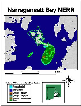
The Narragansett Bay National Estuarine Research Reserve is a Marine Protected Area of the United States located on Prudence, Patience, and Hope islands in Narragansett Bay in the state of Rhode Island.
It was established in August 1980 under the Coastal Zone Management Act. The reserve encompasses 2,353 acres (9.5 km2) of land as well as 1,591 acres (6.4 km2) of water adjoining the islands out to a depth of 18 feet (5.5 m). During the colonial era, all three islands were used for farming. By the 20th century, farming had declined and Prudence Island began to attract summer residents. During World War II, the U.S. military established a presence on the island and remained until 1972, when the land was turned over to the state of Rhode Island.
It encompasses coastal, estuarine, and tidal habitats.
The reserve is managed by the Rhode Island Department of Environmental Management as a federal/state partnership in cooperation with NOAA.

Narragansett Bay is a bay and estuary on the north side of Rhode Island Sound covering 147 square miles (380 km2), 120.5 square miles (312 km2) of which is in Rhode Island. The bay forms New England's largest estuary, which functions as an expansive natural harbor and includes a small archipelago. Small parts of the bay extend into Massachusetts.
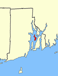
Prudence Island is the third-largest island in Narragansett Bay in the state of Rhode Island and part of the town of Portsmouth, Rhode Island, United States. It is located near the geographical center of the bay. It is defined by the United States Census Bureau as Block Group 3, Census Tract 401.03 of Newport County, Rhode Island. As of the 2010 census, the population was 278 people living on a land area of 14.43 km2.

The National Estuarine Research Reserve System is a network of 29 protected areas established by partnerships between the National Oceanic and Atmospheric Administration (NOAA) and coastal states. The reserves represent different biogeographic regions of the United States. The National Estuarine Research Reserve System protects more than 1.3 million acres of coastal and estuarine habitats for long-term research, water-quality monitoring, education, and coastal stewardship.

The Coastal Zone Management Act of 1972 is an Act of Congress passed in 1972 to encourage coastal states to develop and implement coastal zone management plans (CZMPs). This act was established as a United States National policy to preserve, protect, develop, and where possible, restore or enhance, the resources of the Nation's coastal zone for this and succeeding generations.

The Monterey Bay National Marine Sanctuary (MBNMS) is a US Federally protected marine area offshore of California's Big Sur and central coast. It is the largest US national marine sanctuary and has a shoreline length of 276 miles (444 km) stretching from just north of the Golden Gate Bridge at San Francisco to Cambria in San Luis Obispo County. Supporting one of the world’s most diverse marine ecosystems, it is home to numerous mammals, seabirds, fishes, invertebrates and plants in a remarkably productive coastal environment. The MBNMS was established in 1992 for the purpose of resource protection, research, education, and public use.

Wells National Estuarine Research Reserve, located in Wells, Maine, USA, is 2,250 acres (9.1 km2) of protected land headquartered at a restored saltwater farm called Laudholm. As a National Estuarine Research Reserve, the Wells Reserve works to expand knowledge of coasts and estuaries, engage people in environmental learning, and involve communities in conservation, all with a goal of protecting and restoring coastal ecosystems around the Gulf of Maine. Wells Reserve funding is largely through the National Oceanic and Atmospheric Administration and the nonprofit Laudholm Trust.

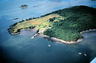
Hope Island is a 91-acre (0.368 km²) island located in Narragansett Bay in the State of Rhode Island. It is part of the Narragansett Bay National Estuarine Research Reserve, along with nearby Prudence Island and Patience Island, and home to colonial wading birds during their nesting season of spring and summer.
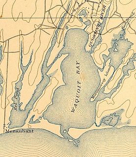
Waquoit Bay is a public national estuary, which is typically used as a research reserve. It is a part of Nantucket Sound and is located on the southern shore of Cape Cod in Massachusetts, USA. This bay forms the border of the towns of Falmouth and Mashpee, Massachusetts.
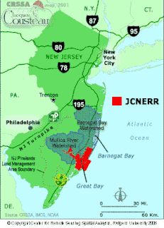
The Jacques Cousteau National Estuarine Research Reserve, located in southeastern New Jersey, encompasses over 110,000 acres (450 km2) of terrestrial, wetland and aquatic habitats within the Mullica River-Great Bay Ecosystem.

Patience Island lies off the northwest coast of Prudence Island in the town of Portsmouth, Rhode Island. It has a land area of 0.33 sq mi, making it the fourth-largest island in Narragansett Bay. Aside from a single 600-square foot house, which is disconnected from the state electrical grid, Patience Island is otherwise uninhabited.
Dyer Island is an island in Narragansett Bay in Rhode Island, United States. It lies off the west coast of Aquidneck Island and is part of Melville CDP, which itself is part of the town of Portsmouth. The island lies between Melville and Prudence Island and is uninhabited and has a land area of 0.12 km² and is only 13 feet above sea level.
Rookery Bay Reserve protects 110,000 acres of coastal lands and waters at the northern end of the Ten Thousand Islands on the gulf coast of Florida, Rookery Bay National Estuarine Research Reserve represents one of the few remaining undisturbed mangrove estuaries in North America.
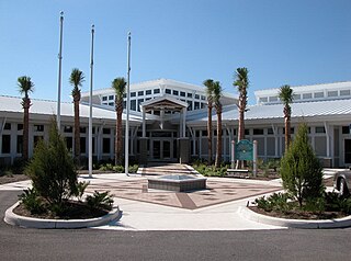
In 1999, the Guana Tolomato Matanzas National Estuarine Research Reserve was designated in St. Johns and Flagler counties, Florida as a part of the National Oceanic and Atmospheric Administration (NOAA) National Estuarine Research Reserve (NERR) system. The GTM Research Reserve represents the east Florida sub-region of the Carolinian bioregion. It is one of 29 NERRs in 23 states and one territory. GTM is one of three NERRs in Florida, and is administered on behalf of the state by the Florida Department of Environmental Protection's Florida Coastal Office as part of a network that includes forty-one aquatic preserves, three NERRs, a National Marine Sanctuary, the Coral Reef Conservation Program and the Florida Oceans and Coastal Council. Additional interests are held in the research and management of the GTM and connected preserved or conserved lands including:

Elkhorn Slough is a 7-mile-long (11 km) tidal slough and estuary on Monterey Bay in Monterey County, California. It is California's second largest estuary and the United States' first estuarine sanctuary. The community of Moss Landing and the Moss Landing Power Plant are located at the mouth of the slough on the bay.

The San Francisco Bay National Estuarine Research Reserve is one of 27 reserves established as part of the United States National Estuarine Research Reserve System. The reserve is used to promote San Francisco Bay wetlands and estuary research, education, and stewardship.
The Great Bay National Estuarine Research Reserve encompasses a diversity of land and water areas around Great Bay, an estuary in southeastern New Hampshire. Protected lands cover 10,235 acres (4,142 ha), including approximately 7,300 acres (3,000 ha) of open water and wetlands that include salt marshes, rocky shores, bluffs, woodlands, open fields, and riverine systems and tidal waters.
The estuarine system of the North Carolina National Estuarine Research Reserve is the third largest in the country, encompassing more the 10,000 acres (4,000 ha). This system is of prime economic importance to the coastal area—90 percent of the commercial seafood species caught in the state spends at least part of their lives in an estuary. The North Carolina National Estuarine Research Reserve was established to preserve these fragile natural areas and the variety of life they support.

Waquoit Bay National Estuarine Research Reserve (WBNERR) encompasses open waters, barrier beaches, marshlands and uplands on the south shore of Cape Cod in the towns of Falmouth and Mashpee. The park is managed by the Department of Conservation and Recreation (DCR) and the National Oceanic and Atmospheric Administration.
Designated in 1991, the Chesapeake Bay National Estuarine Research Reserve - Virginia (CBNERR-VA) is one of 29 protected areas that make up the National Estuarine Research Reserve System (NERRS). Established to promote informed management of the nation's estuaries and coastal habitats, national estuarine research reserves inspire solutions for healthy coasts and maintain strong local economies, effectively functioning as America's bridge between freshwater and salt.
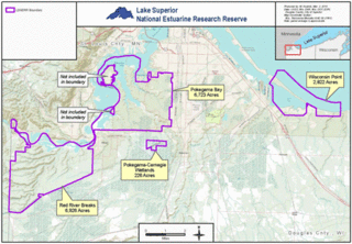
The Lake Superior National Estuarine Research Reserve includes land and water areas along the St. Louis River and Lake Superior in Douglas County, in the northwest corner of Wisconsin, United States. It is one of 29 National Estuarine Research Reserves. The Reserve is operated as a program of the Natural Resources Institute of the University of Wisconsin-Madison Division of Extension. It has an area of 16,697 acres (6,757 ha), and was designated in 2010.