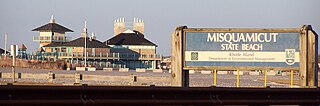
Misquamicut State Beach is a seaside public recreation area in the town of Westerly, Rhode Island. It occupies a portion of Misquamicut Beach, a 3-mile-long (4.8 km) barrier island that extends westward from Weekapaug to Watch Hill and separates Winnapaug Pond from the Atlantic Ocean. The state beach covers 51 acres (21 ha) and features a large beach pavilion with multiple public facilities.

Beavertail State Park is a public recreation area encompassing 153 acres (62 ha) at the southern end of Conanicut Island in Narragansett Bay, Rhode Island. The state park's main attraction is the active Beavertail Lighthouse, the current tower of which dates from 1856. During World War II, the park area was part of Fort Burnside, one of several coastal fortifications designed to protect Narragansett Bay. The park's scenic shoreline offers hiking, picnicking, and saltwater fishing.

Brenton Point State Park is a public recreation area occupying 89 acres (36 ha) at the southwestern tip of Aquidneck Island in the town of Newport, Rhode Island. The state park offers wide vistas of the Atlantic Ocean where it meets Narragansett Bay. The park lies adjacent to the Newport Country Club, part of Newport's Ocean Drive Historic District. It is managed by the Rhode Island Department of Environmental Management, Division of Parks and Recreation, and is overseen by the staff at nearby Fort Adams State Park.

Fort Adams State Park is a public recreation and historic area preserving Fort Adams, a large coastal fortification located at the harbor mouth in Newport, Rhode Island, that was active from 1841 through the first half of the 20th century. The state park hosts the annual Newport Jazz Festival and Newport Folk Festival and is the home of Sail Newport and Eisenhower House.

Colt State Park is a public recreation area that occupies 464 acres (188 ha) on Poppasquash Neck in the town of Bristol, Rhode Island, once owned by industrialist Samuel P. Colt, nephew of firearms manufacturer Samuel Colt. The park is a major component of the Poppasquash Farms Historic District, listed on the National Register of Historic Places, and is a stop on the East Bay Bike Path. The park includes trails, picnic groves, boat ramps, an observation tower, and an open air Chapel-by-the-Sea.
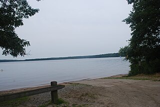
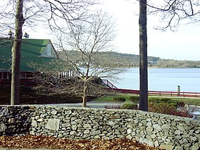
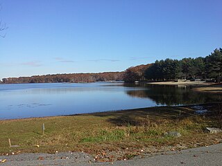
Burlingame State Park is a public recreation area located in the town of Charlestown, Rhode Island. The state park's 3,100 acres (1,300 ha) offer camping, hiking, and water activities on Watchaug Pond. The park's campground abuts the Burlingame Management Area and Kimball Wildlife Sanctuary.

Snake Den State Park is a public recreation area occupying 1,000 acres (400 ha) on U.S. Route 6 in the town of Johnston, Providence County, Rhode Island. The park includes a working farm, Dame Farm, and is largely undeveloped with limited recreational opportunities. The Rhode Island Division of Parks and Recreation is headquartered in the former, 22-room Palazzi family farmhouse. The park is named for a canyon-like fissure on the park grounds.

Scarborough State Beach is a public recreation area fronting the Atlantic Ocean in the town of Narragansett, Rhode Island. The state park occupies 60 acres (24 ha) comprising two units located at 870 and 970 Ocean Road. The beach offers saltwater bathing, picnicking, observation tower, and boardwalk and is open seasonally.
Lincoln Woods State Park is a public recreation area covering 627 acres (254 ha) around Olney Pond four miles (6.4 km) northwest of Pawtucket in the town of Lincoln, Rhode Island. The state park is known for its giant glacial boulders and the stony nature of its terrain which prevented most of the parkland from being used as farmland or for other development.
Fishermen's Memorial State Park is a public recreation area and campground encompassing 91 acres (37 ha) on Point Judith in the town of Narragansett, Rhode Island. The state park occupies a portion of the former Fort Nathaniel Greene, named after Rhode Island native and Revolutionary War general Nathaniel Greene.

Fort Wetherill State Park is a public recreation area occupying 61.5 acres (24.9 ha) at the southeastern tip of Conanicut Island in the town of Jamestown, Rhode Island. The state park sits on the East Passage of Narragansett Bay opposite Fort Adams State Park. From 1901 through World War II, Fort Wetherill and Fort Adams were part of a string of coastal defenses designed to protect the bay's entrance points. The Fort Wetherill battery and training camp were acquired by the State of Rhode Island from the United States in 1972. The park is used for sightseeing, scuba diving, picnicking, boating, fishing, and hiking. As of 2020, the fort itself is almost completely covered in graffiti.

Haines Memorial State Park is public recreation area in the town of Barrington on the northeastern side of Narragansett Bay, six miles (9.7 km) south of East Providence, Rhode Island. The state park offers picnicking, play fields, fishing and boating facilities, and is a stop on the East Bay Bike Path.

World War II Veterans Memorial State Park is a public recreation area located in the city of Woonsocket, Rhode Island. The park occupies land known as the Social flatlands where textile mills operated along the banks of the Mill River until the early years of the 20th century. Since 1979, the park has hosted the three-day Autumnfest celebration held annually on Columbus Day Weekend.

Charlestown Breachway State Beach is a seaside public recreation area on Block Island Sound in the town of Charlestown, Rhode Island. It is located on the east side of the manmade channel that connects Ninigret Pond with the Atlantic Ocean.
East Beach or East State Beach is a seaside public recreation area on Quonochontaug Neck, the narrow barrier island that separates Block Island Sound and Ninigret Pond, in the town of Charlestown, Rhode Island, United States. The state beach encompasses three miles (4.8 km) of oceanfront and abuts Ninigret National Wildlife Refuge.

East Matunuck State Beach is a public recreation area encompassing 144 acres (58 ha) on the shore of Block Island Sound in the town of South Kingstown, Rhode Island. The state beach offers picnicking, ocean swimming, and beach activities. It is open seasonally.
Roger W. Wheeler State Beach is a public recreation area covering 27 acres (11 ha) on Block Island Sound in the town of Narragansett, Rhode Island. The area offers picnicking, ocean swimming, and a playground and is open seasonally.
Salty Brine State Beach is a public recreation area occupying slightly more than one acre (0.40 ha) of ocean shore in the village of Galilee, town of Narragansett, Rhode Island. Established in 1954 as Galilee State Beach, it was renamed in 1990 to honor Salty Brine, a Rhode Island radio and television personality. A 2,800-square-foot (260 m2) beach pavilion and boardwalk were added to the facility in 2010. The area offers ocean swimming and saltwater fishing and is open seasonally.
The Narragansett Runestone, also known as the Quidnessett Rock, is a 2.5 t (2,500 kg) slab of metasandstone located in Rhode Island, United States. It is inscribed with two rows of symbols, which some have indicated resemble ancient runic characters.