Environment and ecology
The Chafee NWR and adjacent lands along the Narrow River (the Pettaquamscutt River), which form the Pettaquamscutt Cove, are a designated Important Bird Area (IBA). The Audubon Society reports that the majority of the Pettaquamscutt Cove IBA is under private ownership or in open water, with smaller portions being part of the Chafee NWR (18.7%), under the ownership of conservation organizations such as the Audubon Society of Rhode Island (3.8%) and the Narrow River Land Trust (3.0%), or owned by municipalities or the State of Rhode Island. [4]
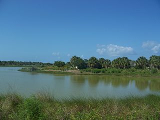
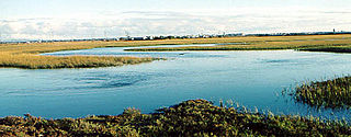
The majority of the John H. Chafee National Wildlife Refuge by acreage consists of forest upland, emergent wetland, forest wetland, and scrub-scrub wetland. [5] Tidal salt marsh is typical within the refuge. [6] [5] Within these areas of the refuge, saltmeadow cordgrass (salt hay) (Spartina patens), salt-marsh cordgrass (S. alterniflora), spike grass ( Distichlis spicata ), saltwort ( Salicornia sp.), and sealavender (Limonium nashii) are dominant plant types. [5]
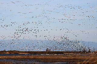
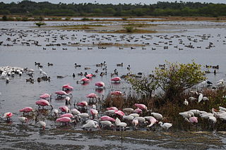
The refuge provides habitat for the largest American black duck population in Rhode Island. [7] The conservation of this migratory bird was the impetus for the creation of the national wildlife refuge. [6] Other waterfowl that inhabit the Pettaquamscutt Cove area include mallard (Anas platyrhynchos), gadwall (A. strepera), American wigeon (A. americana), Canada goose (Branta canadensis), and bufflehead (Bucephala albeola). [4] Salt-marsh and shorebirds that inhabit the region [4] include as the saltmarsh sparrow, also called the saltmarsh sharp-tailed sparrow (Ammodramus caudacutus), [4] [6] [7] as well as the seaside sparrow (A. maritimus), willet (Catoptrophorus semipalmatus), clapper rail (Rallus longirostris), greater yellowlegs (Tringa flavipes), lesser yellowlegs (T. melanoleuca), semipalmated plover (Charadrius semipalmatus), and least sandpiper (Calidris minutilla). [4] Species that inhabit ecotone areas (such as areas between marsh and woodland) include mimic thrushes, red-winged blackbird (Agelaius phoeniceus), common yellowthroat (Geothlypis trichas), and song sparrow (Melospiza melodia). [4] Tide creeks and open water provide habitat for least tern (Sternula antillarum), common tern (terna hirundo), and belted kingfisher (Megaceryle alcyon). [4]
A 1998 study by the Rhode Island Coastal Resources Management Council identified 75 fish species that used the Narrow River at some point in their lives and reported that the Narrow River had the state's largest alewife run. [5] A 2002 FWS report reported that some "28 fish species and 5 shellfish species use the lower section of the river adjacent to the refuge." [5]
History and administration
The refuge, originally named the Pettaquamscutt Cove National Wildlife Refuge, was established on November 5, 1988, as an amendment to Emergency Wetlands Resources Act and National Wildlife Refuge System Administration Act of 1966. [5] The specific legislation creating the refuge is Title II of the Outer Continental Shelf Operations Indemnification Clarification Act of 1988. [8] It was renamed the John H. Chafee National Wildlife Refuge in 1999, in honor of John H. Chafee, the Senator who sponsored the legislation creating the refuge. [7]
The refuge is administered by the U.S. Fish and Wildlife Service (FWS) as part of the Rhode Island National Wildlife Refuge Complex, headquartered in Charlestown, Rhode Island; the complex includes all five National Wildlife Refuges in Rhode Island: Chafee NWR, Block Island NWR, Ninigret NWR, Sachuest Point NWR, and Trustom Pond NWR. [7] [5]
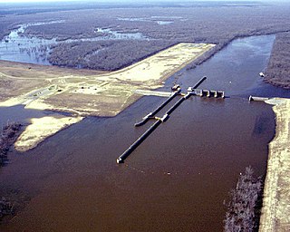
As of 2006, the size of the refuge was 368 acres (149 ha), [7] In 2009, an additional 120 acres (49 ha) were added to the refuge following a dial between the State of Rhode Island and FWS brokered by The Conservation Fund. [3] In the deal, two tracts of land owned by the State of Rhode Island—the "Camp Pastore" property in Charlestown (of 48 acres (19 ha) along the northwest shoreline of Watchaug Pond) and the "Stedman" property (72 acres (29 ha) abutting the refuge in Kingstown —were added to the refuge grounds. [3] The Stedman property was purchased by FWS using funds from the federal Land and Water Conservation Fund, while the state granted a conservation easement over the Camp Pastore property to The Nature Conservancy. [3] The total size of the refuge is now 544 acres (220 ha). [3]
In 2002, FWS estimated the annual visitorship at the Chafee Refuge to be 5,000, although the agency noted that the entire refuge boundary has not been posted and that public use is not monitored. [5] In addition to wildlife observation, waterfowl hunting is permitted at the refuge (by boat access only). [7] Shoreline fishing, canoeing, and kayaking are allowed from designed access points only. [7]
The Felsenthal National Wildlife Refuge (NWR) is a 76,000 acre (307.56 km2) national wildlife refuge located in south-central Arkansas in Ashley, Bradley, and Union counties. Felsenthal NWR is one of three refuges forming an administrative complex, which also includes Pond Creek NWR to the northwest and Overflow NWR to the east.

The White River National Wildlife Refuge is a 160,756 acres (650.56 km2) wildlife refuge located in Desha, Monroe, Phillips, and Arkansas counties in the U.S. state of Arkansas. The refuge is managed by the United States Fish and Wildlife Service. White River NWR borders on Cache River National Wildlife Refuge at its northern boundary. In 1974, the White River Sugarberry Natural Area was designated as a National Natural Landmark by the National Park Service.
The National Wildlife Refuge System (NWRS) is a system of protected areas of the United States managed by the United States Fish and Wildlife Service (FWS), an agency within the Department of the Interior. The National Wildlife Refuge System is the system of public lands and waters set aside to conserve America's fish, wildlife, and plants. Since President Theodore Roosevelt designated Florida's Pelican Island National Wildlife Refuge as the first wildlife refuge in 1903, the system has grown to over 568 national wildlife refuges and 38 wetland management districts encompassing about 859,000,000 acres (3,476,200 km2).
The Sacramento National Wildlife Refuge Complex is part of the United States system of National Wildlife Refuges (NWR). It is located in northern California, in the valley of the Sacramento River.
Pelican Island National Wildlife Refuge is a United States National Wildlife Refuge (NWR), and part of the Everglades Headwaters NWR complex, located just off the western coast of North Hutchinson Island in the Indian River Lagoon east of Sebastian, Florida. The refuge consists of a 3-acre (12,000 m2) island that includes an additional 2.5 acres (10,000 m2) of surrounding water and is located off the east coast of Florida of the Indian River Lagoon. Established by an executive order of President Theodore Roosevelt on March 14, 1903, Pelican Island was the first National wildlife refuge in the United States. It was created to protect egrets and other birds from extinction through plume hunting. The oldest government wildlife refuge of any kind in North America is the Lake Merritt Bird Refuge in Oakland, California. Oakland Mayor Samuel Merritt declared it a wildlife refuge for migrating birds in 1869. In 1870, the state of California designated Lake Merritt a state game refuge.
Merritt Island National Wildlife Refuge is a 140,000-acre (57,000 ha) U.S. National Wildlife Refuge (NWR) on the Atlantic coast of Florida's largest barrier island. NASA's Kennedy Space Center and visitor complex are also situated on the island and NASA can restrict access to the refuge based on its operational needs.

The Erie National Wildlife Refuge is an 8,777-acre (3,552 ha) National Wildlife Refuge located in Crawford County, Pennsylvania. Named after the Erie tribe, it was established to provide waterfowl and other migratory birds with nesting, feeding, brooding, and resting habitat.

Audubon National Wildlife Refuge is a 14,739-acre (5,965 ha) National Wildlife Refuge in the U.S. state of North Dakota. The refuge is managed by the U.S. Fish and Wildlife Service and is the centerpiece of the Audubon National Wildlife Refuge Complex, which includes numerous other refuges in the region. Originally designated as the Snake Creek National Wildlife Refuge in 1955, the refuge was renamed in 1967 in honor of the artist and naturalist John James Audubon. Most of the refuge area is a lake known as Audubon Lake which is managed by the U.S. Army Corps of Engineers.
Seal Beach National Wildlife Refuge is a wildlife refuge encompassing 965 acres (3.91 km2) located in the California coastal community of Seal Beach. Although it is located in Orange County it is included as part of the San Diego National Wildlife Refuge Complex. It was established in 1972.

Sanganois State Fish and Wildlife Area is an Illinois state park on 10,360 acres (4,190 ha) in Cass, Schuyler, and Mason County, Illinois, United States.

Glacial Ridge National Wildlife Refuge was created on October 12, 2004, the 545th National Wildlife Refuge in the United States. Its creation was the result of cooperation between at least 30 agencies or governmental entities. The creation of the refuge was spearheaded by The Nature Conservancy, and the initial endowment of 2,300 acres (9.3 km2) of land was donated by the Conservancy. In light of its planned final size of 37,756 acres (153 km2), it is described by the US Fish and Wildlife Service as "the largest tallgrass prairie and wetland restoration project in U.S. history."
The Blackbeard Island National Wildlife Refuge is a 5,618 acres (2,274 ha) National Wildlife Refuge located in McIntosh county in Georgia. The refuge was established to provide a nature and forest preserve for aesthetic and conservation purposes.
The Anahuac National Wildlife Refuge (NWR) is a wildlife conservation area along the coast of Texas (USA), west of the town of High Island, Texas. It borders East Bay, part of the Galveston Bay complex, behind Bolivar Peninsula at the Gulf of Mexico.

The Izembek National Wildlife Refuge is the smallest of the National Wildlife Refuges located in the U.S. state of Alaska. It lies on the northwest coastal side of central Aleutians East Borough. Almost all of the refuge was designated as wilderness in 1980 under the Alaska National Interest Lands Conservation Act (Anilca). The refuge is administered from offices in Cold Bay.

Straddling the headwaters of the Minnesota River in west-central Minnesota, Big Stone National Wildlife Refuge is within the heart of the tallgrass prairie's historic range. Today, less than one-percent of tallgrass prairie remains.
Pass a Loutre Wildlife Management Area (WMA) is a 115,000-acre (47,000 ha) protected wetland in Plaquemines Parish, Louisiana, United States. The WMA is located due south and bordering the 48,000 acre Delta National Wildlife Refuge, accessible only by air or boat, contains the Pass A L'Outre Lighthouse, and Port Eads is within the boundary.
The William T. Davis Wildlife Refuge (WTDWR) is an 814-acre (3.29 km2) wildlife refuge straddling the New Springville and Travis sections of Staten Island. The park was named in honor of Staten Island native William T. Davis, a renowned naturalist and entomologist who along with the Audubon Society started the refuge with an original acquisition of 52 acres (210,000 m2). Additional acreage was acquired in increments and the park is today 814 acres (3.29 km2). Beginning in 2010, the adjacent 223-acre (0.90 km2) North Park section of Freshkills Park has undergone preparation to serve as an expansion of the wildlife refuge.

The Everglades Headwaters National Wildlife Refuge and Conservation Area, created in 2012, is the newest addition and 556th unit of the United States National Wildlife Refuge (NWR) System. It began with 10 acres (4.0 ha) donated to the conservation effort as part of the Obama administration's America's Great Outdoors Initiative.

Charles E. Wheeler Wildlife Management Area is a 625-acre (253 ha) brackish tidal marsh, nature preserve and hunting area owned by the state of Connecticut located in Devon (village), Milford, New Haven County, Connecticut.

