Woonsocket, is a city in Providence County, Rhode Island, United States. The population was 43,240 at the 2020 census, making it the sixth largest city in the state. Being Rhode Island's northernmost city, Woonsocket lies directly south of the Massachusetts state line and constitutes part of both the Providence metropolitan area and the larger Greater Boston Combined Statistical Area.

The Blackstone River is a river in the U.S. states of Massachusetts and Rhode Island. It flows approximately 48 mi (80 km) and drains a watershed of approximately 540 sq. mi (1,400 km2). Its long history of industrial use has left a legacy of pollution, and it was characterized by the United States Environmental Protection Agency in 1990 as "the most polluted river in the country with respect to toxic sediments."
Route 99, also known as the Woonsocket Industrial Highway, is a numbered state highway running 2.9 miles (4.7 km) in Providence County, Rhode Island, United States. The route is a nominally north–south limited-access freeway for its entire length. Route 99 serves Manville and the Highland Industrial Park, providing freeway access to the city of Woonsocket from Rhode Island Route 146, which bypasses the city. The southern terminus of Route 99 is at a partial interchange with Route 146 in Lincoln. The freeway has one interchange in Manville, a village in Lincoln, before terminating at an at-grade intersection with Rhode Island Route 122 in Woonsocket.

Toronto Parks, Forestry and Recreation (PFR) is the division of Toronto's municipal government responsible for maintaining the municipal park system and natural spaces, regulation of and provision of urban forestry services, and the delivery of recreational programming in city-operated facilities.

The John H. Chafee Blackstone River Valley National Heritage Corridor is a National Heritage Corridor dedicated to the history of the early American Industrial Revolution, including mill towns stretching across 24 cities and towns near the river's course in Worcester County, Massachusetts and Providence County, Rhode Island. It makes up a historical area in the Blackstone Valley and is named for the late US Senator from Rhode Island John Chafee. In 2014, the Blackstone River Valley National Historical Park was created out of a smaller portion of the National Heritage Corridor. Both units now exist as cooperative entities. The organization is headquartered at the building in Woonsocket Depot Square which is located at 1 Depot Square, Woonsocket, RI 02895.

Misquamicut State Beach is a seaside public recreation area in the town of Westerly, Rhode Island. It occupies a portion of Misquamicut Beach, a 3-mile-long (4.8 km) barrier island that extends westward from Weekapaug to Watch Hill and separates Winnapaug Pond from the Atlantic Ocean. The state beach covers 51 acres (21 ha) and features a large beach pavilion with multiple public facilities.

Brenton Point State Park is a public recreation area occupying 89 acres (36 ha) at the southwestern tip of Aquidneck Island in the town of Newport, Rhode Island. The state park offers wide vistas of the Atlantic Ocean where it meets Narragansett Bay. The park lies adjacent to the Newport Country Club, part of Newport's Ocean Drive Historic District. It is managed by the Rhode Island Department of Environmental Management, Division of Parks and Recreation, and is overseen by the staff at nearby Fort Adams State Park.

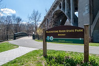
The Blackstone River Greenway is a partially completed 48-mile (77 km) paved rail trail defining the course of the East Coast Greenway through the Blackstone Valley from Worcester, Massachusetts to Providence, Rhode Island.

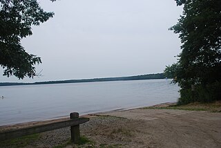
Burlingame State Park and Campground is a public recreation area located in the town of Charlestown, Rhode Island. The state park's 3,100 acres (1,300 ha) offer camping, hiking, and water activities on Watchaug Pond.

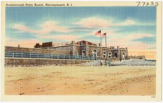
Scarborough State Beach is a public recreation area fronting the Atlantic Ocean in the town of Narragansett, Rhode Island. The state park occupies 60 acres (24 ha) comprising two units located at 870 and 970 Ocean Road. The beach offers saltwater bathing, picnicking, observation tower, and boardwalk.

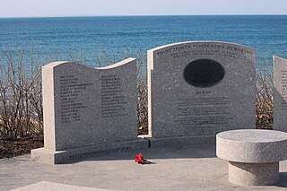
Fishermen's Memorial State Park is a public recreation area and campground encompassing 91 acres (37 ha) on Point Judith in the town of Narragansett, Rhode Island. The state park occupies a portion of the former Fort Nathaniel Greene, named after Rhode Island native and Revolutionary War general Nathaniel Greene.

Fort Wetherill State Park is a public recreation area occupying 61.5 acres (24.9 ha) at the southeastern tip of Conanicut Island in the town of Jamestown, Rhode Island. The state park sits on the East Passage of Narragansett Bay opposite Fort Adams State Park. From 1901 through World War II, Fort Wetherill and Fort Adams were part of a string of coastal defenses designed to protect the bay's entrance points. The Fort Wetherill battery and training camp were acquired by the State of Rhode Island from the United States in 1972. The park is used for sightseeing, scuba diving, picnicking, boating, fishing, and hiking. As of 2020, the fort itself is almost completely covered in graffiti.

Goddard Memorial State Park is a public recreation area occupying 490 acres (200 ha) along the shores of Greenwich Cove and Greenwich Bay in Warwick, Rhode Island. The state park grounds were once the estate of Civil War officer and Rhode Island politician Robert Goddard, whose children gave the land to the state in 1927 as a memorial to their father. The park features a nine-hole golf course, an equestrian area with 18 miles (29 km) of bridle trails, swimming beach, canoeing area, picnicking facilities, game fields, and a performing arts center.

Charlestown Breachway State Beach is a seaside public recreation area on Block Island Sound in the town of Charlestown, Rhode Island. Located on the east side of the manmade channel that connects Ninigret Pond with the Atlantic Ocean, the area offers 75 camping sites for self-contained RVs, ocean swimming, beach activities, salt-water fishing, and a boat launch.

East Beach or East State Beach is a seaside public recreation area on Quonochontaug Neck, the narrow barrier island that separates Block Island Sound and Ninigret Pond, in the town of Charlestown, Rhode Island, United States. The state beach encompasses three miles (4.8 km) of oceanfront and abuts Ninigret National Wildlife Refuge. The area offers a 20-unit seasonal campground, salt-water fishing, ocean swimming, and beach activities.

East Matunuck State Beach is a public recreation area encompassing 144 acres (58 ha) on the shore of Block Island Sound in the town of South Kingstown, Rhode Island. The state beach offers picnicking, ocean swimming, and beach activities.

Roger W. Wheeler State Beach is a public recreation area covering 27 acres (11 ha) on Block Island Sound in the town of Narragansett, Rhode Island. The area offers picnicking, ocean swimming, and a playground.

Salty Brine State Beach is a public recreation area occupying slightly more than one acre (0.40 ha) of ocean shore in the village of Galilee, town of Narragansett, Rhode Island. Established in 1954 as Galilee State Beach, it was renamed in 1990 to honor Salty Brine, a Rhode Island radio and television personality. The area offers ocean swimming and saltwater fishing. A 2,800-square-foot (260 m2) beach pavilion and boardwalk were added to the facility in 2010.
The Rhode Island Department of Environmental Management (RIDEM) is a Rhode Island state government agency charged with supervising and controlling the protection, development, planning, and utilization of the natural resources of the state, including, but not limited to: water, plants, trees, soil, clay, sand, gravel, rocks and other minerals, air, mammals, birds, reptiles, amphibians, fish, shellfish, and other forms of aquatic, insect, and animal life.


