
Wickliffe Mounds is a prehistoric, Mississippian culture archaeological site located in Ballard County, Kentucky, just outside the town of Wickliffe, about 3 miles (4.8 km) from the confluence of the Ohio and Mississippi rivers. Archaeological investigations have linked the site with others along the Ohio River in Illinois and Kentucky as part of the Angel phase of Mississippian culture. Wickliffe Mounds is controlled by the State Parks Service, which operates a museum at the site for interpretation of the ancient community. Listed on the National Register of Historic Places, it is also a Kentucky Archeological Landmark and State Historic Site.

This is a list of properties and districts in Illinois that are on the National Register of Historic Places. There are over 1,900 in total. Of these, 85 are National Historic Landmarks. There are listings in all of the state's 102 counties.
This National Park Service list is complete through NPS recent listings posted August 4, 2023.

SunWatch Indian Village / Archaeological Park, previously known as the Incinerator Site, and designated by the Smithsonian trinomial 33-MY-57, is a reconstructed Fort Ancient Native American village next to the Great Miami River. The dwellings and site plan of the 3-acre (1.2 ha) site are based on lengthy archeological excavations sponsored by the Dayton Society of Natural History, which owns and operates the site as an open-air museum. Because of its archaeological value, the site was listed in 1974 on the National Register of Historic Places. Since that time, as the many years of archaeological research at the site have led to important findings about the Fort Ancient culture, SunWatch Indian Village was designated in 1990 as a National Historic Landmark.
The Hickory Ridge Cemetery Archeological Site (8ES1280) is an archaeological site in Pensacola, Escambia County Florida. It is located north of Big Lagoon and west of Pensacola. During excavations in the 1980s carbon dating was done on burnt wood fragments associated with burials in the mound, with a determination that the site had been used c. 1450. Analysis of ceramics suggested it was a Mississippian culture site, probably from the Late Bottle Creek Phase or Early Bear Point Phases of the Pensacola culture. It was a cemetery associated with a village nearby, (8ES1052). On September 22, 2000, it was added to the U.S. National Register of Historic Places.
The Waddells Mill Pond Site is an archaeological site located seven miles northwest of Marianna, Florida. On December 15, 1972, it was added to the U.S. National Register of Historic Places.

The Nodena site is an archeological site east of Wilson, Arkansas, and northeast of Reverie, Tennessee, in Mississippi County, Arkansas, United States. Around 1400–1650 CE an aboriginal palisaded village existed in the Nodena area on a meander bend of the Mississippi River. The Nodena site was discovered and first documented by Dr. James K. Hampson, archaeologist and owner of the plantation on which the Nodena site is located. Artifacts from this site are on display in the Hampson Museum State Park in Wilson, Arkansas. The Nodena site is the type site for the Nodena phase, believed by many archaeologists to be the province of Pacaha visited by Spanish explorer Hernando de Soto in 1542.

The Eaker site (3MS105) is an archaeological site on Eaker Air Force Base near Blytheville, Arkansas, that was declared a National Historic Landmark in 1996. The site is the largest and most intact Late Mississippian Nodena phase village site within the Central Mississippi Valley, with archaeological evidence indicating a palisaded village some 50 acres (20 ha) in size, with hundreds of structures. The site's major period of occupation was 1350–1450 CE, although evidence of occupation dates back to 600 CE. The site is also hypothesized to have been occupied by the Quapaw prior to a migration further south, after which they made contact with Europeans in the late 17th century.
Parkin Archeological State Park, also known as Parkin Indian Mound, is an archeological site and state park in Parkin, Cross County, Arkansas. Around 1350–1650 CE an aboriginal palisaded village existed at the site, at the confluence of the St. Francis and Tyronza rivers. Artifacts from this site are on display at the site museum. The Parkin site is the type site for the Parkin phase, an expression of the Mississippian culture from the Late Mississippian period. Many archeologists believe it to be part of the province of Casqui, documented as visited by Spanish explorer Hernando de Soto in 1542. Archeological artifacts from the village of the Parkin people are dated to 1400–1650 CE.

Towosahgy State Historic Site (23MI2), also known as Beckwith's Fort Archeological Site, is a large Mississippian archaeological site with a Woodland period Baytown culture component located in Mississippi County, Missouri, United States. It is believed to have been inhabited from c. 400–1350 CE. The site is maintained by the Missouri Department of Natural Resources as a state historic site. The name Towosahgy is an Osage word which means "old town". It is not known if members of the historic Osage people, who dominated a large area of present-day Missouri at the beginning of the 19th century, ever occupied the site. The site was acquired by the Missouri state park system in 1967 and added to the National Register of Historic Places in 1969 as NRIS number 69000113.
This is a list of the National Register of Historic Places listings in St. Clair County, Illinois.

The C.H. Nash Museum at Chucalissa is located on and exhibits excavated materials of the Mississippian culture archaeological site known as Chucalissa which means "abandoned house" in Chickasaw. The site is located adjacent to the T. O. Fuller State Park within the city of Memphis, Tennessee, United States. Chucalissa was designated National Historic Landmark in 1994 due to its importance as one of the best-preserved and major prehistoric settlement sites in the region.

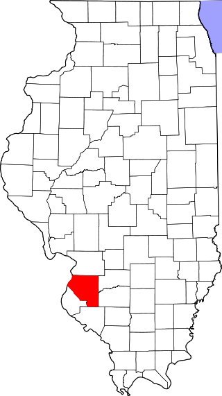
This is a list of the National Register of Historic Places listings in Monroe County, Illinois.
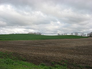
The Ware Mounds and Village Site (11U31), also known as the Running Lake Site, located west of Ware, Illinois, is an archaeological site comprising three platform mounds and a 160-acre (65 ha) village site. The site was inhabited by the Late Woodland and Mississippian cultures from c. 800 to c. 1300. The village is one of the only Mississippian villages known to have existed in the Mississippi River valley in Southern Illinois. As the village was located near two major sources of chert, which Mississippian cultures used to make agricultural tools, it was likely a trading center for the mineral.
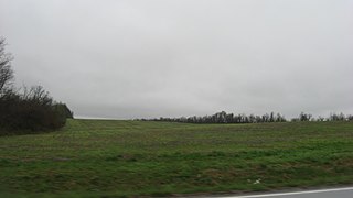
The Orr-Herl Mound and Village Site is an archaeological site located along the Ohio River in Hardin County, Illinois, United States. The site consists of a mound, which includes a sizable midden, and the remains of a village. The village was inhabited from roughly 900 to 1500 AD by Mississippian peoples. The site was an important source of fluorspar, which Mississippian peoples used for carvings and beads. The village was likely a manufacturing site for fluorspar items, which were then traded to other villages; this theory is supported by fluorspar artifacts recovered from the Kincaid Site, a Mississippian chiefdom center on the Ohio River in Illinois.

The Cleiman Mound and Village Site is a prehistoric archaeological site located near the Mississippi River in Jackson County, Illinois. The site includes an intact burial mound and the remains of a village site. The village was inhabited by a number of prehistoric cultures during the Archaic, Woodland, and Mississippian periods; settlement at the site began prior to 400 B.C. and lasted through 1300 A.D. The mound was built during the Middle Woodland Period by Hopewellian peoples and is likely the only Hopewell mound in the Mississippi Valley in Southern Illinois.

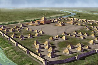
The Emerald Mound and Village Site is a pre-Columbian archaeological site located northwest of the junction of Emerald Mound Grange and Midgley Neiss Roads in St. Clair County, Illinois. The site includes five mounds, two of which have been destroyed by modern activity, and the remains of a village. Middle Mississippian peoples inhabited the village, which was a satellite village of Cahokia. The largest of the mounds is a two-tiered structure that stands 50 feet (15 m) high; its square base is 300 feet (91 m) across, while its upper tier is 150 feet (46 m) across. At the time of its discovery, the mound was the second-largest known in Illinois after Monks Mound at Cahokia.

The Mitchell Archaeological Site is a pre-Columbian archaeological site located at the western end of University Drive in Mitchell, Illinois. The site includes a platform mound and the remains of a village; while it once included several other mounds, they have been destroyed by modern activity. Mississippian peoples inhabited the site c. 1150–1200. The site is affiliated with the Cahokia settlement system and was the largest site in the system except for Cahokia itself. However, the majority of the site was destroyed by the construction of Interstate 270; known information about the site mainly comes from salvage excavations conducted before the highway was built.
The Seven Mile Island Archeological District is an archeological site on an island in the Tennessee River in Colbert and Lauderdale County, Alabama. The island is believed to have been inhabited for about 9,000 years, with the earliest artifacts dated to the early Archaic Period. Out of 18 sites identified on the island, two have had extensive study. The Perry Site (1Lu25) is a seven-foot (2.1-meter) thick midden containing ceramic potsherds from the Archaic period. The Seven Mile Island site (1Lu21) is a Mississippian village site and mound. A number of arrowheads and flint knives, as well as a bottle with an engraved bird have been found at the site. 41 burials from the Mississippian era were also unearthed.
The Rock Creek Archeological District is a pair of archaeological sites near Maud, Colbert County, Alabama. The sites contain remnants from the Archaic, Gulf Formational, Woodland, and Mississippian Periods. One of the sites, ACt 44, shows evidence of two major habitations, a hunting camp from the Late Archaic period and a Late Mississippian farm village, although ceramics and arrowheads from other eras have also been recovered. Most artifacts from the other site, ACt 45, date from the Gulf Formational period. The sites were discovered by National Park Service archaeologist A. Wayne Prokopetz in 1975, with major surveys being completed by Christopher E. Hamilton in 1977 and by Memphis State University researchers in 1980. The district was listed on the National Register of Historic Places in 1990.

The Larson Site is a prehistoric archaeological site in Fulton County, Illinois, near the city of Lewistown. The site was the location of a Mississippian town and was occupied during the 13th and 14th centuries. The town was one of seven major town sites in the central Illinois River valley and served as a social and economic center for surrounding villages and farms. The artifacts uncovered at the site have been well-preserved and include both organic remains and intact homes, providing significant archaeological evidence regarding the Mississippian way of life.


