Jaketown Site

Last updated

Jaketown Site
Jaketown Site.jpg
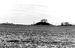
Roadside view of the site
USA Mississippi location map.svg
Red pog.svg
Usa edcp location map.svg
Red pog.svg
Nearest city Belzoni, Mississippi
Coordinates 33°14′13.542″N90°29′13.2936″W / 33.23709500°N 90.487026000°W / 33.23709500; -90.487026000
Area200 acres (81 ha)
NRHP reference No. 73001017
Significant dates
Added to NRHPJune 19, 1973 [1]
Designated NHLDecember 14, 1990 [2]
Designated USMSDecember 6, 1985 [3]
Arrowheads from the Jaketown Site Jaketown Site arrowheads.jpg
Arrowheads from the Jaketown Site

Jaketown Site (22 HU 505) is an archaeological site with two prehistoric earthwork mounds in Humphreys County, Mississippi, United States. [1] While the mounds have not been excavated, distinctive pottery shards found in the area lead scholars to date the mounds' construction and use to the Mississippian culture period, roughly 1100 CE to 1500 CE.

Contents

The site was a complex regional trade center that developed and was inhabited much earlier, from 2000 to 600 BCE, during the Poverty Point culture within the Late Archaic period of the United States. [4] This culture is seen in more than 100 sites on both sides of the Mississippi River, from present-day Louisiana to Mississippi; it also was linked to more distant areas through a trading network. The site has evidence of trade in raw materials and manufacture of finished items that were distributed through the network throughout the Eastern United States. The largest and most elaborate earthwork complex of the period is at Poverty Point, Louisiana.

The mounds were constructed as part of a later, succeeding culture, built to mark the political and religious center of a chiefdom. There would have been numerous elite residences nearby, as well as structures to support certain crafts. Because of its importance of a regional trade center of the Poverty Point culture in the Archaic period, and long human occupation, the site was declared a National Historic Landmark in 1990. [2] The mounds are listed on the Mississippi Mound Trail. [5] It is managed by the state of Mississippi. Mississippi Highway 7 is routed near the site, which is approximately seven miles north of Belzoni. [4]

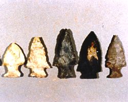
Artifacts found in the area near the site are featured on display in the Jaketown Museum in Belzoni. [6] Dating of the artifacts has demonstrated that the Jaketown site was occupied by indigenous peoples from 1750 BCE to 1500 CE, making it one of the oldest continuously inhabited sites in the region. [7]

Archeological investigations have found that the smaller mounds nearby were hundreds of years older than the surviving two; they were built by peoples of a preceding culture. They were destroyed by plowing and being razed for use as fill for road construction in the early 20th century. The largest platform mound at the site, Mound B, is 23 feet (7.0 m) in height with a base of 150 feet (46 m) by 200 feet (61 m). It has a projection on its eastern side that is thought to have been a ramp once used as a stairway. To its northwest is Mound C, another platform mound with a height of 15 feet (4.6 m). [4]

See also

Related Research Articles

<span class="mw-page-title-main">Hopewell tradition</span> Ancient North American indigenous civilization

The Hopewell tradition, also called the Hopewell culture and Hopewellian exchange, describes a network of precontact Native American cultures that flourished in settlements along rivers in the northeastern and midwestern Eastern Woodlands from 100 BCE to 500 CE, in the Middle Woodland period. The Hopewell tradition was not a single culture or society but a widely dispersed set of populations connected by a common network of trade routes.

<span class="mw-page-title-main">Etowah Indian Mounds</span> Archaeological site in Georgia, U.S.

Etowah Indian Mounds (9BR1) are a 54-acre (220,000 m2) archaeological site in Bartow County, Georgia, south of Cartersville. Built and occupied in three phases, from 1000–1550 CE, the prehistoric site is located on the north shore of the Etowah River.

<span class="mw-page-title-main">Serpent Mound</span> Prehistoric effigy mound in Ohio, United States

The Great Serpent Mound is a 1,348-feet-long (411 m), three-feet-high prehistoric effigy mound located in Peebles, Ohio. It was built on what is known as the Serpent Mound crater plateau, running along the Ohio Brush Creek in Adams County, Ohio. The mound is the largest serpent effigy known in the world.

<span class="mw-page-title-main">Mississippian culture</span> Native American culture in the United States (800 - 1600)

The Mississippian culture was a Native American civilization that flourished in what is now the Midwestern, Eastern, and Southeastern United States from approximately 800 to 1600, varying regionally. It was known for building large, earthen platform mounds, and often other shaped mounds as well. It was composed of a series of urban settlements and satellite villages linked together by loose trading networks. The largest city was Cahokia, believed to be a major religious center located in what is present-day southern Illinois.

<span class="mw-page-title-main">Mound Builders</span> Pre-Columbian cultures of North America

Many pre-Columbian cultures in North America were collectively termed "Mound Builders", but the term has no formal meaning. It does not refer to specific people or archaeological culture but refers to the characteristic mound earthworks that indigenous peoples erected for an extended period of more than 5,000 years. The "Mound Builder" cultures span the period of roughly 3500 BCE to the 16th century CE, including the Archaic period, Woodland period, and Mississippian period. Geographically, the cultures were present in the region of the Great Lakes, the Ohio River Valley, Florida, and the Mississippi River Valley and its tributary waters.

<span class="mw-page-title-main">Letchworth-Love Mounds Archaeological State Park</span> State park in Florida, United States

Letchworth Mounds Archaeological State Park is a 188.2 acre Florida State Park that preserves the state's tallest prehistoric, Native American ceremonial earthwork mound, which is 46 feet (14 m) high. It is estimated to have been built 1100 to 1800 years ago. This is one of three major surviving mound complexes in the Florida Panhandle. It is believed to have been built by the Weedon Island Culture, Native Americans who lived in North Florida. The hierarchical society planned and constructed massive earthwork mounds as expression of its religious and political system.

<span class="mw-page-title-main">Watson Brake</span> Archaeological site in Louisiana, US

Watson Brake is an archaeological site in present-day Ouachita Parish, Louisiana, from the Archaic period. Dated to about 5400 years ago, Watson Brake is considered the oldest earthwork mound complex in North America. It is older than the Ancient Egyptian pyramids or Britain’s Stonehenge. Its discovery and dating in a paper published in 1997 changed the ideas of American archaeologists about ancient cultures in the Southeastern United States and their ability to manage large, complex projects over centuries. The archeologists revised their date of the oldest earthwork construction by nearly 2000 years, as well as having to recognize that it was developed over centuries by a hunter-gatherer society, rather than by what was known to be more common of other, later mound sites: a more sedentary society dependent on maize cultivation and with a hierarchical, centralized polity.

<span class="mw-page-title-main">Indigenous peoples of the Southeastern Woodlands</span> Indigenous groups in the US

Indigenous peoples of the Southeastern Woodlands, Southeastern cultures, or Southeast Indians are an ethnographic classification for Native Americans who have traditionally inhabited the area now part of the Southeastern United States and the northeastern border of Mexico, that share common cultural traits. This classification is a part of the Eastern Woodlands. The concept of a southeastern cultural region was developed by anthropologists, beginning with Otis Mason and Franz Boas in 1887. The boundaries of the region are defined more by shared cultural traits than by geographic distinctions. Because the cultures gradually instead of abruptly shift into Plains, Prairie, or Northeastern Woodlands cultures, scholars do not always agree on the exact limits of the Southeastern Woodland culture region. Shawnee, Powhatan, Waco, Tawakoni, Tonkawa, Karankawa, Quapaw, and Mosopelea are usually seen as marginally southeastern and their traditional lands represent the borders of the cultural region.

<span class="mw-page-title-main">Shiloh Indian Mounds Site</span> United States historic place

Shiloh Indian Mounds Site (40HR7) is an archaeological site of the South Appalachian Mississippian culture. It is located beside the Tennessee River on the grounds of the Shiloh National Military Park, in Hardin County of southwestern Tennessee. A National Historic Landmark, it is one of the largest Woodland era sites in the southeastern United States.

<span class="mw-page-title-main">Poverty Point culture</span> Archaeological culture that inhabited the lower Mississippi Valley

The Poverty Point culture is the archaeological culture of a prehistoric indigenous peoples who inhabited a portion of North America's lower Mississippi Valley and surrounding Gulf coast from about 1730 – 1350 BC.

<span class="mw-page-title-main">Nodena site</span> Archaeological site in Arkansas, United States

The Nodena site is an archeological site east of Wilson, Arkansas, and northeast of Reverie, Tennessee, in Mississippi County, Arkansas, United States. Around 1400–1650 CE an aboriginal palisaded village existed in the Nodena area on a meander bend of the Mississippi River. The Nodena site was discovered and first documented by Dr. James K. Hampson, archaeologist and owner of the plantation on which the Nodena site is located. Artifacts from this site are on display in the Hampson Museum State Park in Wilson, Arkansas. The Nodena site is the type site for the Nodena phase, believed by many archaeologists to be the province of Pacaha visited by Spanish explorer Hernando de Soto in 1542.

<span class="mw-page-title-main">Kincaid Mounds State Historic Site</span> Archaeological site in Illinois, US

The Kincaid Mounds Historic Site c. 1050–1400 CE, is a Mississippian culture archaeological site located at the southern tip of present-day U.S. state of Illinois, along the Ohio River. Kincaid Mounds has been notable for both its significant role in native North American prehistory and for the central role the site has played in the development of modern archaeological techniques. The site had at least 11 substructure platform mounds, and 8 other monuments.

<span class="mw-page-title-main">Emerald Mound site</span> United States historic place

The Emerald Mound site, also known as the Selsertown site, is a Plaquemine culture Mississippian period archaeological site located on the Natchez Trace Parkway near Stanton, Mississippi, United States. The site dates from the period between 1200 and 1730 CE. It is the type site for the Emerald Phase of the Natchez Bluffs Plaquemine culture chronology and was still in use by the later historic Natchez people for their main ceremonial center. The platform mound is the second-largest Mississippian period earthwork in the country, after Monk's Mound at Cahokia, Illinois.

<span class="mw-page-title-main">Grand Village of the Natchez</span> United States historic place

Grand Village of the Natchez, also known as the Fatherland Site, is a 128.1-acre (0.518 km2) site encompassing a prehistoric indigenous village and earthwork mounds in present-day south Natchez, Mississippi. The village complex was constructed starting about 1200 CE by members of the prehistoric Plaquemine culture. They built the three platform mounds in stages. Another phase of significant construction work by these prehistoric people has been dated to the mid-15th century. It was named for the historic Natchez people, who used the site in the 17th and 18th centuries.

<span class="mw-page-title-main">Winterville site</span> Archaeological site in Washington County, Mississippi, United States

The Winterville site is a major archaeological site in unincorporated Washington County, Mississippi, north of Greenville and along the river. It consists of major earthwork monuments, including more than twelve large platform mounds and cleared and filled plazas. It is the type site for the Winterville Phase of the Lower Yazoo Basin region of the Plaquemine Mississippian culture. Protected as a state park, it has been designated as a National Historic Landmark.

<span class="mw-page-title-main">Plaquemine culture</span> Archaeological culture in the lower Mississippi River Valley, United States

The Plaquemine culture was an archaeological culture centered on the Lower Mississippi River valley. It had a deep history in the area stretching back through the earlier Coles Creek and Troyville cultures to the Marksville culture. The Natchez and related Taensa peoples were their historic period descendants. The type site for the culture is the Medora site in Louisiana; while other examples include the Anna, Emerald, Holly Bluff, and Winterville sites in Mississippi.

<span class="mw-page-title-main">Poverty Point</span> Prehistoric site of the Poverty Point culture in northeastern Louisiana, United States

Poverty Point State Historic Site/Poverty Point National Monument is a prehistoric earthwork constructed by the Poverty Point culture, located in present-day northeastern Louisiana. Evidence of the Poverty Point culture extends throughout much of the Southeastern Woodlands of the Southern United States. The culture extended 100 miles (160 km) across the Mississippi Delta and south to the Gulf Coast.

Marsden Mounds is an archaeological site with components from the Poverty Point culture and the Troyville-Coles Creek period. It is located in Richland Parish, Louisiana, near Delhi. It was added to the NRHP on August 4, 2004, as NRIS number 04000803. It is the type site for the Marsden Phase of the Tensas Basin and Natchez Bluff regions local chronology.

<span class="mw-page-title-main">Pocahontas Mounds</span>

Pocahontas Mounds is an archaeological site from the Plaquemine Mississippian culture in Hinds County, Mississippi, dating from 800 to 1300 CE. Two mounds from the site were added to the NRHP on two separate occasions, Pocahontas Mound A on November 25, 1969, as NRIS number 69000365 and Pocahontas Mound B on April 11, 1972, as NRIS number 72000694. The mounds are listed on the Mississippi Mound Trail.

References

  1. 1 2 "National Register Information System". National Register of Historic Places . National Park Service. January 23, 2007.
  2. 1 2 "Jaketown Site". National Historic Landmark summary listing. National Park Service. Archived from the original on June 6, 2011. Retrieved October 22, 2007.
  3. "Mississippi Landmarks" (PDF). Mississippi Department of Archives and History. May 2008. Archived from the original (PDF) on October 9, 2010. Retrieved May 13, 2009.
  4. 1 2 3 "Jaketown Site". National Park Service. Retrieved April 2, 2011.
  5. "Mississippi Mound Trail". Mississippi Department of Archives and History. Retrieved July 13, 2021.
  6. "Attractions". Visit Belzoni. Retrieved April 24, 2015.
  7. "Belzoni Visitor Attractions" Archived 2010-02-15 at the Wayback Machine , Belzoni-Humphreys Development Foundation, accessed 26 Oct 2009